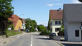
Schönenbaumgarten
| Schönenbaumgarten | ||
|---|---|---|
| State : |
|
|
| Canton : |
|
|
| District : | Kreuzlingen | |
| Political community : | Langrickenbach | |
| Postal code : | 8585 | |
| former BFS no. : | 4663 | |
| Coordinates : | 734 991 / 275236 | |
| Height : | 499 m above sea level M. | |
| Area : | 1.56 km² | |
| Residents: | 153 (December 31, 2018) | |
| Population density : | 98 inhabitants per km² | |
|
Schönenbaumgarten |
||
| map | ||
|
|
||
Schönenbaumgarten is a village in the municipality of Langrickenbach in the Kreuzlingen district of the canton of Thurgau in Switzerland .
From 1803 to 1997 Schönenbaumgarten was a local community in the Illighausen municipal community . On January 1, 1998 , the local communities of Schönenbaumgarten, Dünnershaus , Herrenhof , Langrickenbach and Zuben merged to form the political municipality of Langrickenbach.
geography
Schönenbaumgarten is located on the Seerücken a good six kilometers southeast of Kreuzlingen .
history
The settlement was first mentioned in 1261 as the beautiful bong garden . The Episcopal Palatine Chapel of St. Peter in Constance owned property in Schönenbaumgarten in 1377. Presumably therefore this belonged partly to the Bischofshöri Konstanz and later to the Vogtei Eggen . In 1288, the Münsterlingen monastery acquired the bailiwick rights over Schönenbaumgarten from the barons of Klingen and added them to his jurisdiction , to which the village remained subordinate until 1798. Schönenbaumgarten was always parish after Altnau . From 1798 to 1803 Schönenbaumgarten formed a municipality with an agent.
Grain was grown in three tents, fruit and grass were also grown and, from the middle of the 19th century, dairy farming was increased. There were two mills with a hemp grater in operation until 1870, and there was also a lime distillery. Schönenbaumgarten was still dominated by agriculture in the 20th century. In 1920 the first economic sector employed 75% of the workforce, in 1980 33%. The third sector increased from 4% in 1920 to 41% in 1980.
population
| year | 1831 | 1850 | 1900 | 1950 | 1990 | 2000 | 2010 | 2018 |
| Local parish | 93 | 98 | 94 | 110 | 139 | |||
| Locality | 142 | 132 | 153 | |||||
| source | ||||||||
Of the total of 153 inhabitants in Schönenbaumgarten in 2018, 32 or 20.9% were foreign nationals. 70 (45.8%) were Protestant Reformed and 31 (20.3%) were Roman Catholic.
literature
- Erich Trösch: Schönenbaumgarten. In: Historical Lexicon of Switzerland .
This article is largely based on the entry in the Historisches Lexikon der Schweiz (HLS), which, according to the HLS's usage information, is licensed under the Creative Commons - Attribution - Distribution under the same conditions 4.0 International (CC BY-SA 4.0) license .
Web links
Individual evidence
- ↑ Swiss land use statistics. Completed on July 1, 1912. Published by the Federal Statistical Bureau. ( Memento from April 12, 2016 in the Internet Archive )
- ↑ a b c d Localities and their resident population. Edition 2019 . On the website of the Statistical Office of the Canton of Thurgau (Excel table; 0.1 MB), accessed on April 28, 2020.
- ↑ Locations and Settlements Directory. Canton of Thurgau, 2005 edition . On the website of the Statistical Office of the Canton of Thurgau (PDF; 1.7 MB), accessed on April 28, 2020.
- ↑ Locations and Settlements Directory. Canton of Thurgau, 2012 edition. On the website of the Statistical Office of the Canton of Thurgau (PDF; 3.4 MB), accessed on May 11, 2020.
Remarks
- ↑ with outside courtyards


