
Salenstein
| Salenstein | |
|---|---|
 |
|
| Country: |
|
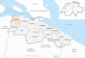
| Canton : | Thurgau (TG) |
| District : | Kreuzlingen |
| Postal code : | 8268 |
| BFS no. : | 4851 (Political Community) |
| former BFS no .: | 4853 (local parish ) |
| Coordinates : | 721008 / 281604 |
| Height : | 400 m above sea level M. |
| Area : | 6.54 km² (Pol. Municipality) 2.89 km² (local municipality) |
| Residents: | 1323 (December 31, 2018) |
| Population density : | 202 inhabitants per km² |
| Website: | www.www.salenstein.ch |
 Salenstein village square |
|
| map | |
  |
|
Salenstein , in the local dialect Saleschte [ ˈsaləʃtə ], is a political municipality and a place in the district of Kreuzlingen in the Swiss canton of Thurgau .
From 1816 to 1979 the municipalities of Fruthwilen , Mannenbach and Salenstein formed the municipality of Salenstein, and in 1979 the municipality of Salenstein merged with its local communities to form the unitary municipality of Salenstein.
geography
The political municipality of Salenstein is located on the south bank of the Untersee opposite the island of Reichenau and consists of the villages of Salenstein, Mannenbach and Fruthwilen . The village of Salenstein is located on a terrace on the ridge between Berlingen and Ermatingen .
Origin of name
The first mention of the name Salenstein comes from 1092. The name Salenstein is interpreted in different ways by research. The Old High German words salo (dirty, cloudy, dark) and stein (stone, rock, castle) mean "with the dark-colored stone" or "with the dark-colored castle". It should refer to the gray sandstone on which the upper castle was built. Another interpretation refers to the old word Salen for pastures , as can still be seen in the name and coat of arms of the local community Salen-Reutenen .
history

In Salenstein there are three burial mounds from the Hallstatt period . Salenstein Castle was built in the 11th century and, like the younger Sandegg and Riederen castles, was inhabited by ministers from Reichenau Abbey . The most important basic rights and rulership rights have always belonged to the monastery, which also exercised the lower jurisdiction . In 1483 there was an opening . In 1798 the Richau Lower Court was repealed and replaced by a district court based on Helvetian uniformity .
![]()
1401, the nobles Clare of Breitenstein founded in Götsch wood the beguines house Blümlistobel . The Augustinian rule was introduced in the small monastery before 1520, the building burned down in 1534 and was rebuilt in 1537. The last sister lived in Blümlistobel until 1545 and then transferred it to the Reichenau Monastery in exchange for a personal asset (usufructuary right). Ecclesiastically, Salenstein, which was reformed by the majority from 1529, shared the fate of Ermatingen, to whose parish and parish it belongs.
![]()
In the early modern times , Salenstein got into debt, whereupon it had to apply for credit several times and in 1573 had to use its Allmendwald as security . Thanks to the mild climate, vines, fruit crops (cherries) and gardens were created. Around 1750 a home industry developed (weavers and knitters). In 1817, Hortense , the adopted daughter of Napoleon I, acquired Arenenberg Castle and converted it into a residence in exile. Due to its preferred residential area, Salenstein is a wealthy or one of the most tax-favorable municipality in the canton. From 1798 to 2010 Salenstein belonged to the Steckborn district .
→ see also section history in article Fruthwilen
→ see also section history in article Mannenbach
coat of arms
Blazon : Split yellow and white, covered with blue Ten Berg .
The coat of arms comes from the Lords of Salenstein . After the formation of the Salenstein community in 1979, the coat of arms of the local community Salenstein was adopted by the new community.
population
 |
| 1850 | 1900 | 1950 | 1970 | 1980 | 2000 | 2010 | 2018 | |
|---|---|---|---|---|---|---|---|---|
| Unified Church | 882 | 1108 | 1278 | 1318 | ||||
| Municipal parish | 890 | 782 | 850 | 876 | ||||
| Local parish | 459 | 380 | 396 | 459 | ||||
| source | ||||||||
Of the total of 1318 inhabitants in the municipality of Salenstein in 2018, 361 or 27.4% were foreign nationals. 511 (38.8%) were Protestant Reformed and 358 (27.2%) were Roman Catholic. The village of Salenstein had 493 residents at that time.

economy
In 2016, Salenstein offered 308 jobs (converted to full-time positions). 9.5% of these were employed in agriculture and forestry, 13.6% in industry, trade and construction and 76.9% in the service sector.
Attractions
The village of Mannenbach-Salenstein is listed in the inventory of places worth protecting in Switzerland .
There are still five castles in the municipality today. The sixth, Sandegg Castle , burned down in 1833. The others are Arenenberg , Eugensberg and Salenstein , as well as Louisenberg Castle in the Mannenbach district and Hubberg Castle in the Fruthwilen district .
photos

View of Mannenbach and Salenstein Castle
Parish hall

Old school house

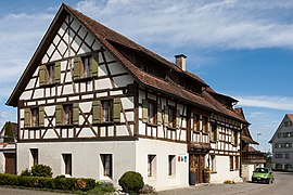
Frame construction

school

Arenenberg Castle


Personalities
- Eugène de Beauharnais (1781–1824), son of Napoleon Bonaparte, had the Eugensberg Castle built
- Hortense de Beauharnais (1783–1837), Queen of Holland
- Napoleon III (1808–1873), French President from 1848 to 1852 and Emperor of the French from 1852 to 1870
- Eugénie de Montijo (1826–1920), wife of Napoléon III. and from 1853 to 1870 Empress of the French
- Alexander von Herder (1826–?), Chamberlain from Saxony-Weimar, grandson of Johann Gottfried Herder and owner of Salenstein Castle from 1869
- Paul Ilg (1875–1957), Swiss writer
- Ferdinand Hardekopf (1876–1954), German writer, lived in Mannenbach and Salenstein around 1912
- René Schickele (1883–1940), German-French writer, lived in Salenstein from 1911 to 1916
- Anneliese Rothenberger (1924–2010), lived in Salenstein
- Rolf Erb (1951–2017), Swiss entrepreneur and convicted fraudster, lived in Salenstein at Eugensberg Castle until his death
- Ruth Maria Kubitschek (* 1931), German actress, lives in Salenstein
- Pierre Kaffer (* 1976), German racing driver
- Mattias Ekström (* 1978), Swedish racing driver (DTM)
- Tony Martin (* 1985), German cyclist and multiple world champion in the individual time trial, lives in Mannenbach
literature
- Hans Baumgartner: Salenstein - Fruthwilen - Mannenbach. Book for the 900th anniversary 1092–1992. Frauenfeld 1992.
- Peter Erni: The Steckborn district. In The Art Monuments of the Canton of Thurgau VI. Bern 2001.
- Erni Keller: Saleschter Dialäkt. Expressions and idioms from the period 1930–1950. Ermatingen 2012.
- Alfons Raimann, Peter Erni: The art monuments of the Canton of Thurgau, Thurgau VI. The Steckborn district. Edited by the Society for Swiss Art History GSK. Bern 2001, ISBN 3-906131-02-5 (= Art Monuments of Switzerland, Volume 98).
Web links
Individual evidence
- ↑ a b Thurgau in figures 2019 . On the website of the Statistical Office of the Canton of Thurgau (PDF file; 1.8 MB), accessed on April 28, 2020.
- ↑ Swiss land use statistics. Completed on July 1, 1912. Published by the Federal Statistical Bureau. ( Memento from April 12, 2016 in the Internet Archive )
- ↑ Permanent and non-permanent resident population by year, canton, district, municipality, population type and gender (permanent resident population). In: bfs. admin.ch . Federal Statistical Office (FSO), August 31, 2019, accessed on December 22, 2019 .
- ↑ a b Localities and their resident population. Edition 2019 . On the website of the Statistical Office of the Canton of Thurgau (Excel table; 0.1 MB), accessed on April 28, 2020.
-
↑ a b c d e f Erich Trösch: Salenstein. In: Historical Lexicon of Switzerland .
These sections are largely based on the entry in the Historical Lexicon of Switzerland (HLS), which, according to the HLS's usage information, is under the Creative Commons license - Attribution - Share under the same conditions 4.0 International (CC BY-SA 4.0). - ↑ a b The history of Salenstein. On the website of the municipality of Saltenstein, accessed on December 15, 2019
- ↑ Lexicon of Swiss municipality names . Edited by the Center de Dialectologie at the University of Neuchâtel under the direction of Andres Kristol. Frauenfeld / Lausanne 2005, p. 786.
- ↑ a b National map of Switzerland 1: 25,000, sheet 1033 Steckborn, 1990
- ↑ a b municipal coat of arms . On the website of the State Archives of the Canton of Thurgau, accessed on December 8, 2019
- ↑ a b Population development of the municipalities. Canton Thurgau, 1850–2000 and resident population of the municipalities and change from the previous year. Canton of Thurgau, 1990–2018. On the website of the Statistical Office of the Canton of Thurgau (Excel tables; 0.1 MB each), accessed on April 28, 2020.
- ↑ Salensteiner mourn the opera star. In: Stern , May 26, 2010.
Altnau | Bottigh furnace | Ermatingen | Love God | Güttingen | Kemmental | Kreuzlingen | Langrickenbach | Lengwil | Münsterlingen | Raperswilen | Salenstein | Tägerwilen | Waldi
Former parishes: Alterswilen | Altishausen | Dippishausen-Oftershausen | Dot night | Dünnershaus | Egelshofen | Ellighausen | Emmishofen | Engwilen | Fruthwilen | Hattenhausen-Hefenhausen | Manor | Hugelshofen | Illighausen | Kurzrickenbach | Land battle | Lipperswil | Lippoldswilen | Mannenbach | Neuwilen | Oberhofen near Kreuzlingen | Joking | Schönenbaumgarten | Siegershausen | Sonterswil | Triboltingen | Zuben
Canton of Thurgau | Districts of the Canton of Thurgau | Municipalities of the Canton of Thurgau