
Fruthwilen
| Fruthwilen | ||
|---|---|---|
 |
||
| State : |
|
|
| Canton : |
|
|
| District : | Kreuzlingen | |
| Political community : | Salenstein | |
| Postal code : | 8269 | |
| former BFS no. : | 4851 | |
| Coordinates : | 722 271 / 280176 | |
| Height : | 518 m above sea level M. | |
| Area : | 3.03 km² | |
| Residents: | 554 (December 31, 2018) | |
| Population density : | 183 inhabitants per km² | |
| Website: | www.fruthwilen.ch | |
 Fruthwilen |
||
| map | ||
|
||

Fruthwilen is a village in the political municipality of Salenstein in the Kreuzlingen district of the canton of Thurgau in Switzerland .
Until 1978, Fruthwilen formed a local community in the municipal community of Salenstein. In 1979, the local churches Fruthwilen, united Mannenbach and Salenstein for unified community Salenstein.
geography
The row village Fruthwilen is located on the northern slope of the Seerücken on the main road Ermatingen - Märstetten . In addition to Fruthwilen, the hamlets Eggishof and Hub belong to the local community .
history

The oldest written mention of Fruthwilens comes from the year 1271 as "Vruotwilar". The name means courtyard of Fruoto, from ahd. Fruot , smart.
In the Middle Ages the Reichenau Monastery in Fruthwilen was the landlord and court lord . After the abbey was incorporated into the Konstanz monastery in 1540, the lower court of Fruthwilen with Fruthwilen, Helsighausen, Höhnwilen, Raperswilen and several houses from Fischbach was under the bishop until 1798 and was administered by the Obervogtei Reichenau. Before 1798, Hub was part of the Konstanz Monastery of St. Johann , Eggishof was part of the Konstanz Hospital .
Ecclesiastically, Fruthwilen always belonged to Ermatingen. In the joint community was in the 18th century next to the Protestant mayor, a Catholic secondary mayor and vice versa.
In the 19th century, viticulture and fruit growing as well as small businesses gained in importance in the village economy. With the transition to dairy farming - the dairy was established in 1881 - fruit growing was intensified; the viticulture, however, disappeared almost completely. After the middle of the 20th century, various businesses began to settle in Fruthwilen. More recently, the attractive location above the Untersee has led to the development of new single-family house quarters, which have permanently changed the appearance of the town since 1970.
coat of arms
The Fruthwilen coat of arms has an eventful history. In the winter of 1979/80, at the request of the population, the old coat of arms depicted was reinstated, which was lost for a while and could be traced using an old rifle flag.
population
| year | 1850 | 1900 | 1950 | 1970 | 2000 | 2010 | 2018 |
| Local parish | 245 | 254 | 252 | 224 | |||
| Locality | 407 | 419 | 554 | ||||
| source | |||||||
Of the total of 554 inhabitants in the town of Fruthwilen in 2018, 157 or 28.3% were foreign nationals. 206 (37.2%) were Protestant Reformed and 156 (28.2%) were Roman Catholic.
Attractions

The Hubberg Castle is documented since 1377th The double house, which was redesigned inside Baroque style at the beginning of the 18th century, consists of two almost identical halves with large arched portals. It has two solid floors and a half-timbered floor.
After the Second World War, Hans Leip rented the Hubberg for twenty years. The German poet wrote the text of the world-famous soldier song Lili Marleen in 1915 .
photos

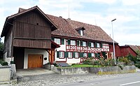
Hauptstrasse 54
Hauptstrasse 38

Poststrasse 3

Old school house

Oberdorf 5

Oberdorf 1


literature
- Hans Baumgartner (text), Werner Stelder (photos) :: Salenstein, Fruthwilen, Mannenbach. 900th Anniversary Book; 1092-1992 . Salenstein parish, Frauenfeld 1992.
- Peter Erni, Alfons Raimann: The Steckborn district (The art monuments of the canton of Thurgau; Bd. 6). GSK, Bern 2001, ISBN 3-906131-02-5 .
Web links
Individual evidence
- ↑ Swiss land use statistics. Completed on July 1, 1912. Published by the Federal Statistical Bureau. ( Memento from April 12, 2016 in the Internet Archive )
- ↑ a b c d Localities and their resident population. Edition 2019 . On the website of the Statistical Office of the Canton of Thurgau (Excel table; 0.1 MB), accessed on April 28, 2020.
- ↑ Population development of the municipalities. Canton of Thurgau, 1850-2000. On the website of the Statistical Office of the Canton of Thurgau (Excel table; 0.1 MB), accessed on April 28, 2020.
-
↑ a b c d e f
Verena Rothenbühler: Fruthwilen. In: Historical Lexicon of Switzerland .
These sections are largely based on the entry in the Historical Lexicon of Switzerland (HLS), which, according to the HLS's usage information, is under the Creative Commons license - Attribution - Share under the same conditions 4.0 International (CC BY-SA 4.0). - ↑ ortsnames.ch. Portal for Swiss place name research, accessed on February 1, 2020
- ↑ Fruthwil coat of arms. On the website of the municipality of Salenstein, accessed on February 1, 2020
- ↑ Locations and Settlements Directory. Canton of Thurgau, 2005 edition . On the website of the Statistical Office of the Canton of Thurgau (PDF; 1.7 MB), accessed on April 28, 2020.
- ↑ Locations and Settlements Directory. Canton of Thurgau, 2012 edition. On the website of the Statistical Office of the Canton of Thurgau (PDF; 3.4 MB), accessed on May 11, 2020.
Remarks
- ↑ with outside courtyards
Altnau | Bottigh furnace | Ermatingen | Love God | Güttingen | Kemmental | Kreuzlingen | Langrickenbach | Lengwil | Münsterlingen | Raperswilen | Salenstein | Tägerwilen | Waldi
Former parishes: Alterswilen | Altishausen | Dippishausen-Oftershausen | Dot night | Dünnershaus | Egelshofen | Ellighausen | Emmishofen | Engwilen | Fruthwilen | Hattenhausen-Hefenhausen | Manor | Hugelshofen | Illighausen | Kurzrickenbach | Land battle | Lipperswil | Lippoldswilen | Mannenbach | Neuwilen | Oberhofen near Kreuzlingen | Joking | Schönenbaumgarten | Siegershausen | Sonterswil | Triboltingen | Zuben
Canton of Thurgau | Districts of the Canton of Thurgau | Municipalities of the Canton of Thurgau