
Emmishofen
| Emmishofen | ||
|---|---|---|
| State : |
|
|
| Canton : |
|
|
| District : | Kreuzlingen | |
| Political community : | Kreuzlingen | |
| Postal code : | 8280 | |
| Coordinates : | 729 574 / 279085 | |
| Height : | 415 m above sea level M. | |
| Area : | 3.20 km² | |
| Residents: | 5929 (December 31, 2010) | |
| Population density : | 1853 inhabitants per km² | |
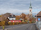
 Emmishofen, in the background Lake Constance and Hagnau |
||
| map | ||
|
||

Emmishofen was a Kirchdorf and an independent community in the canton of Thurgau in Switzerland until it became a part of the community of Kreuzlingen in 1928 after it was incorporated .
geography
Emmishofen is located at the foot of the northern slope of the Seerücken on the Way of St. James and at the intersection of the main roads Schaffhausen – Rorschach and Konstanz – Frauenfeld . With the opening of the Etzwilen – Konstanz railway line , Emmishofen received the Emmishofen train station located on the municipal boundary of Kreuzlingen , which has been called Kreuzlingen since it was incorporated.
history

The place was first mentioned in 1159 as Eminshoven . In the early Middle Ages , Emmishofen belonged to the Bishop of Constance as Bischofshöri . From 1500 it was one of the so-called high courts , which were directly subordinate to the federal governor in Thurgau . Around 1700 the lower court came as an afterfief to the Landschreiber family von Reding, in whose possession it remained until 1798. In 1816 the local community of Emmishofen separated from the municipal community of Tägerwilen and formed an independent municipal community. In 1870 the local and municipal parish of Emmishofen, which were spatially identical, were merged to form the unified municipality of Emmishofen, which merged with the political municipality of Kreuzlingen in 1928.
| year | 1850 | 1880 | 1900 | 1920 |
| Residents | 695 | 1153 | 1558 | 1646 |

Emmishofen and Bernrain were originally located in the Konstanz parish of St. Stephan . After the Reformation , Emmishofen returned to the old faith in 1548. The Catholic parish of Emmishofen gradually emerged from the Swiss part of the parish of St. Stephan in the 19th century. In 1803 the abbey of St. Stephan was abolished , in 1818 the branch relationship was dissolved and in 1831 the Catholic parish of Emmishofen was created, to which the area of the Protestant parish of Alterswilen - but without Altishausen - was allocated. From 1831 the Bernrain Chapel served as a Catholic parish church, the task of which has been taken over by the new Catholic Church of St. Stephan since 1903. In 1930 the Catholic parish of Kreuzlingen-Emmishofen was formed.
In the 19th century, the inhabitants were mainly involved in agriculture and viticulture. With the factory for pyrotechnics in 1840 and the aluminum foil rolling mill Robert Viktor Nehers in 1910, the first industries settled in Emmishofen.
Attractions
Castles and Palaces
In Emmishofen you can find the castles Girsberg , Ebersberg (formerly Ober-Girsberg) and Brunegg (formerly Unter-Girsberg), Bernegg and Irsee, which was the residence of the German revolutionary publicist Johann Georg August Wirth from 1842 to 1847 . The former Granegg Castle was destroyed in a fire in 1891. The remains of a castle stable can be found on the Schlossbühel above Emmishofen .
Heiligkreuz chapel in Bernrain
The chapel , built around 1388 on the Way of St. James , became a place of pilgrimage in connection with the legend of a cruel cruel in the 15th century .
Parish Church of St. Stephan


On July 7, 1903, a separate church in the neo-baroque style was consecrated in Emmishofen and, like the Konstanz mother parish, also called St. Stephan. The architect was Albert Rimli (1872–1954).
The Emmishofer pilgrimage route
As part of the Schwabenweg , the Emmishofer Pilgrimage Route has probably been used by pilgrims from southern Germany on their way to Einsiedeln since the 11th or 12th century . After leaving the Kreuzlinger Tor in Constance, the path followed the Saubach to the Irsee castle, from there to the “Zum Englischen Gruss” house.
From there, continue up the Seerücken in a northerly direction, past Schlösschen Bernegg to the Bernrain Chapel. Then through the forest to Schwaderloh , where the next pilgrim hostel was in the Löwen.
Personalities
- Walter Bissegger (1853–1915), Swiss politician
- Juli Merz-Schmid (1865–1934), Swiss journalist, women's rights activist
- Johann Ludwig Anderwert (1802–1876), Swiss politician
- Robert Victor Neher (1886–1918) Swiss industrialist
photos
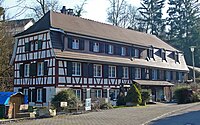
Former pilgrim hostel "Adler"
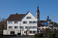
Schoolhouse and Church
Half-timbered house on Mühlestrasse

Emmishofer customs


literature
- Hermann Strauss: Emmishofen. (Contributions to the local history of Kreuzlingen. No. 7). Kreuzlingen 1953.
- Guido Nünlist: Heiligkreuz pilgrimage chapel on Bernrain. Kreuzlingen 1988.
- Hans Peter Mathis: The parish church of St. Stephan in Emmishofen. (Contributions to the local history of Kreuzlingen. No. 27). Kreuzlingen 1994.
Web links
Individual evidence
- ↑ Swiss land use statistics. Completed on July 1, 1912. Published by the Federal Statistical Bureau. ( Memento from April 12, 2016 in the Internet Archive )
- ↑ Locations and Settlements Directory. Canton of Thurgau, 2012 edition. On the website of the Statistical Office of the Canton of Thurgau (PDF; 3.4 MB), accessed on May 11, 2020.
-
↑ a b c d e Verena Rothenbühler: Emmishofen. In: Historical Lexicon of Switzerland .
These sections are largely based on the entry in the Historical Lexicon of Switzerland (HLS), which, according to the HLS's usage information, is under the Creative Commons license - Attribution - Share under the same conditions 4.0 International (CC BY-SA 4.0).
Altnau | Bottigh furnace | Ermatingen | Love God | Güttingen | Kemmental | Kreuzlingen | Langrickenbach | Lengwil | Münsterlingen | Raperswilen | Salenstein | Tägerwilen | Waldi
Former parishes: Alterswilen | Altishausen | Dippishausen-Oftershausen | Dot night | Dünnershaus | Egelshofen | Ellighausen | Emmishofen | Engwilen | Fruthwilen | Hattenhausen-Hefenhausen | Manor | Hugelshofen | Illighausen | Kurzrickenbach | Land battle | Lipperswil | Lippoldswilen | Mannenbach | Neuwilen | Oberhofen near Kreuzlingen | Joking | Schönenbaumgarten | Siegershausen | Sonterswil | Triboltingen | Zuben
Canton of Thurgau | Districts of the Canton of Thurgau | Municipalities of the Canton of Thurgau