
Land battle TG
| TG is the abbreviation for the canton of Thurgau in Switzerland and is used to avoid confusion with other entries in the name Landschlacht . |
| Land battle | ||
|---|---|---|
 |
||
| State : |
|
|
| Canton : |
|
|
| District : | Kreuzlingen | |
| Political community : | Munsterlingen | |
| Postal code : | 8597 | |
| former BFS no. : | 4687 | |
| Coordinates : | 735 798 / 276 778 | |
| Height : | 408 m above sea level M. | |
| Area : | 2.91 km² | |
| Residents: | 1452 (December 31, 2018) | |
| Population density : | 499 inhabitants per km² | |
 Land battle from the "Zeppelin perspective" |
||
| map | ||
|
||

Landschlacht is a former municipality and a village in the municipality of Münsterlingen in the Kreuzlingen district of the canton of Thurgau in Switzerland .
The local community Landschlacht was from 1803 to 1993 part of the municipal community Scherzingen , with which it was united on January 1, 1994 to form the political community of Münsterlingen .
geography
Landschlacht is located in the agglomeration of Kreuzlingen and Konstanz on Lake Constance on the main road Schaffhausen – Rorschach and consists of the Vorder-, the Hinter- and the Seedorf. Landschlacht has had a stop on the Kreuzlingen – Romanshorn railway line since 2002 .
history

The first people settled on the shores of Lake Constance as early as the Neolithic Age , which is proven by many finds. The settlement was first mentioned as Lanchasalachi in 817 . Landschlacht was an episcopal-Constance fiefdom . In the High Middle Ages, the bailiwick belonged to the barons of Güttingen and later to other families. In 1413 half of the judicial rule was sold to Hans Dürrenmüller and ten co-prisoners from Landschlacht, the other half went to the Petershausen Monastery in 1452 and to the Münsterlingen Monastery in 1486 . In 1621 the eleven owner families sold their stake in Münsterlingen Monastery, where it remained until 1798.
Landschlacht always shared the fate of the Altnau parish . The St. Leonhard Chapel, built before 1000, is decorated with Gothic frescoes .

In 1855 the three tents still existed, cattle breeding as well as fruit and wine growing were carried out. A cheese dairy was established in 1880. From 1898 the vines were destroyed because of phylloxera infestation . In the 19th and 20th centuries, work was offered by industry and the canton hospitals that had existed since 1840 . Landschlacht experienced its first building boom from 1961.
population
| year | 1850 | 1900 | 1950 | 1990 | 2000 | 2018 |
| Local parish | 492 | 473 | 585 | 1026 | ||
| Locality | 1006 | 1452 | ||||
| source | ||||||
Of the total of 1,452 inhabitants in Landschlacht in 2018, 452 or 31.1% were foreign nationals. 498 (34.3%) were Protestant Reformed and 456 (31.4%) were Roman Catholic.
photos

Former tithe house
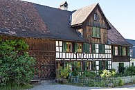
Vorderdorfstrasse 24

Vorderdorfstrasse 28

Restaurant «Frohsinn»
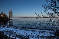
Shores of Lake Constance

View of the clinic from Konstanz


.jpg)
literature
- Erich Trösch: Land battle. In: Historical Lexicon of Switzerland .
This article is largely based on the entry in the Historisches Lexikon der Schweiz (HLS), which, according to the HLS's usage information, is licensed under the Creative Commons - Attribution - Distribution under the same conditions 4.0 International (CC BY-SA 4.0) license .
Web links
Individual evidence
- ↑ Swiss land use statistics. Completed on July 1, 1912. Published by the Federal Statistical Bureau. ( Memento from April 12, 2016 in the Internet Archive )
- ↑ a b c d Localities and their resident population. Edition 2019 . On the website of the Statistical Office of the Canton of Thurgau (Excel table; 0.1 MB), accessed on April 28, 2020.
- ↑ Locations and Settlements Directory. Canton of Thurgau, 2005 edition . On the website of the Statistical Office of the Canton of Thurgau (PDF; 1.7 MB), accessed on April 28, 2020.
Remarks
- ↑ with outside courtyards
Altnau | Bottigh furnace | Ermatingen | Love God | Güttingen | Kemmental | Kreuzlingen | Langrickenbach | Lengwil | Münsterlingen | Raperswilen | Salenstein | Tägerwilen | Waldi
Former parishes: Alterswilen | Altishausen | Dippishausen-Oftershausen | Dot night | Dünnershaus | Egelshofen | Ellighausen | Emmishofen | Engwilen | Fruthwilen | Hattenhausen-Hefenhausen | Manor | Hugelshofen | Illighausen | Kurzrickenbach | Land battle | Lipperswil | Lippoldswilen | Mannenbach | Neuwilen | Oberhofen near Kreuzlingen | Joking | Schönenbaumgarten | Siegershausen | Sonterswil | Triboltingen | Zuben
Canton of Thurgau | Districts of the Canton of Thurgau | Municipalities of the Canton of Thurgau