
Neuwilen
| Neuwilen | ||
|---|---|---|
 |
||
| State : |
|
|
| Canton : |
|
|
| District : | Kreuzlingen | |
| Political community : | Kemmental | |
| Postal code : | 8566 | |
| former BFS no. : | 4636 | |
| Coordinates : | 727 456 / 275753 | |
| Height : | 547 m above sea level M. | |
| Area : | 3.72 km² | |
| Residents: | 549 (December 31, 2018) | |
| Population density : | 148 inhabitants per km² | |
 Neuwilen |
||
| map | ||
|
||

Neuwilen is a former municipality and a village in the municipality of Kemmental in the Kreuzlingen district of the canton of Thurgau in Switzerland . The village of Neuwilen on the main road Frauenfeld - Kreuzlingen with the hamlets of Oberstöcken and Schwaderloh formed a local parish of the municipality of Alterswilen from 1803 to 1995 . On 1 January 1996 merged the local church to church Neuwilen Kemmental.
history

The settlement was first mentioned in 1159 as Nunewillare . Originally located in the Konstanzer Bischofshöri , Neuwilen belonged to the Eggen Vogtei by the middle of the 13th century at the latest . In 1447 it came under the jurisdiction of the Raiti Court of the city of Constance , where it remained until 1798. The rights of the community were laid down in the court opening in 1490 and later in community letters .
Neuwilen was parish first to St. Stephan in Konstanz, then to Tägerwilen and, since the 13th century, always to Alterswilen. After the Reformation in 1529, the few Catholics went to church in Bernrain , from 1831 they belonged to the parish of Emmishofen and today to the parish of Kreuzlingen- Emmishofen.
Neuwilen acquired 150 hectares of forest from the canton in 1805. After grain cultivation in the Dreizelgenwirtschaft , cattle and dairy farming began in the 19th century. A village cheese dairy was established in 1865 and has only been a milk receiving point since 1958. A beer brewery was active from 1845 to 1880, numerous hand stickers from 1870 to 1910 and from 1878 a sieve and wire goods factory. From 1967 to 1987 goods were amalgamated. Since 1992 the A7 motorway has passed through the area of the then local community.
population
| year | 1850 | 1900 | 1950 | 1990 | 2000 | 2010 | 2018 |
| Local parish | 429 | 409 | 351 | 356 | |||
| Locality | 326 | 365 | 549 | ||||
| source | |||||||
Of the total of 549 inhabitants in Neuwilen in 2018, 130 or 23.7% were foreign nationals. 218 (39.7%) were Protestant Reformed and 139 (25.3%) were Roman Catholic.
photos

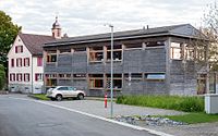
Old and new school building

Schonthal, Untereuwilen
.jpg)

Web links
Individual evidence
- ↑ Swiss land use statistics. Completed on July 1, 1912. Published by the Federal Statistical Bureau. ( Memento from April 12, 2016 in the Internet Archive )
- ↑ a b c d Localities and their resident population. Edition 2019 . On the website of the Statistical Office of the Canton of Thurgau (Excel table; 0.1 MB), accessed on April 28, 2020.
-
↑ a b c d e André Salathé: Lippoldswilen. In: Historical Lexicon of Switzerland .
These sections are largely based on the entry in the Historical Lexicon of Switzerland (HLS), which, according to the HLS's usage information, is under the Creative Commons license - Attribution - Share under the same conditions 4.0 International (CC BY-SA 4.0). - ↑ Locations and Settlements Directory. Canton of Thurgau, 2005 edition . On the website of the Statistical Office of the Canton of Thurgau (PDF; 1.7 MB), accessed on April 28, 2020.
- ↑ Locations and Settlements Directory. Canton of Thurgau, 2012 edition. On the website of the Statistical Office of the Canton of Thurgau (PDF; 3.4 MB), accessed on May 11, 2020.
Remarks
- ↑ with outside courtyards
Altnau | Bottigh furnace | Ermatingen | Love God | Güttingen | Kemmental | Kreuzlingen | Langrickenbach | Lengwil | Münsterlingen | Raperswilen | Salenstein | Tägerwilen | Waldi
Former parishes: Alterswilen | Altishausen | Dippishausen-Oftershausen | Dot night | Dünnershaus | Egelshofen | Ellighausen | Emmishofen | Engwilen | Fruthwilen | Hattenhausen-Hefenhausen | Manor | Hugelshofen | Illighausen | Kurzrickenbach | Land battle | Lipperswil | Lippoldswilen | Mannenbach | Neuwilen | Oberhofen near Kreuzlingen | Joking | Schönenbaumgarten | Siegershausen | Sonterswil | Triboltingen | Zuben
Canton of Thurgau | Districts of the Canton of Thurgau | Municipalities of the Canton of Thurgau