Hartenauerbach
|
Hartenauerbach Hartenau Bach |
||
|
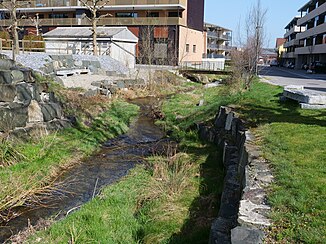
The revitalized Hartenauerbach in the center of Tobel . |
||
| Data | ||
| Water code | CH : 2071 | |
| location | Canton of Thurgau | |
| River system | Rhine | |
| Drain over | Leek → Murg → Thur → Rhine → North Sea | |
| source | Hallway Schürli the Hof Ueterschen ( Braunau ) 47 ° 30 '19 " N , 9 ° 5' 41" O |
|
| Source height | 735 m above sea level M. | |
| muzzle | in the leek near Affeltrangen Coordinates: 47 ° 31 '37 " N , 9 ° 1' 59" E ; CH1903: 720 075 / 265 231 47 ° 31 '37 " N , 9 ° 1' 59" O |
|
| Mouth height | 487 m above sea level M. | |
| Height difference | 248 m | |
| Bottom slope | 32 ‰ | |
| length | 7.8 km | |
| Catchment area | 7.27 km² | |
| Discharge at the mouth of A Eo : 7.27 km² |
MQ Mq |
130 l / s 17.9 l / (s km²) |
| Communities | Braunau , Tobel-Tägerschen , Affeltrangen | |
The Hartenauerbach is a 7.8 km long left tributary of the Lauche in the Münchwilen district of the Swiss canton of Thurgau .
Its longest spring stream rises southwest of the Hombärg in the municipality of Braunau and flows in a westerly direction past Füürhüüsere . After merging with a tributary on the right, the brook crosses the Hartenau, then forms an approximately 2 km long forest gorge, which it leaves at the village of Tobel , where it turns north to flow from the left into the leek of about the same size at Affeltrangen .
Revitalization
In the center of Tobel, the Hartenauerbach was revitalized between 2013 and 2014.
Individual evidence
- ↑ a b Geographic information system of the Canton of Thurgau
- ↑ Geoserver of the Swiss Federal Administration ( information )
- ↑ Topographical catchment areas of Swiss waters: sub-catchment areas 2 km². Retrieved August 3, 2020 .
- ↑ Mean discharge and discharge regime type for the Swiss water network. Retrieved August 3, 2020 .
- ↑ Revitalization and bank access Hartenauerbach, Tobel-Tägerschen Center ( Memento from December 4, 2014 in the Internet Archive ), accessed on May 1, 2018
|
Tributaries and hydraulic structures
|
||||||||||||||||||||||||||||||||||||||||||||||||||||||||||||
