
Weinfelden district
| Weinfelden district | |
|---|---|
| Basic data | |
| Country: |
|
| Canton : |
|
| Main town : | Weinfelden |
| FSO number : | 2015 |
| Area : | 227.08 km² |
| Height range : | 404–775 m above sea level M. |
| Residents: | 55,830 (December 31, 2018) |
| Population density : | 246 inhabitants per km² |
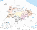
| map | |
 |
|
Weinfelden is a district in the canton of Thurgau . The main town is Weinfelden .
The following 18 municipalities belong to the district (as of January 1, 2011):
| coat of arms | Name of the parish | Population (December 31, 2018) |
Area in km² |
Inhabitant per km² |
|---|---|---|---|---|
|
|
Affeltrangen | 2552 | 14.43 | 177 |
|
|
Amlikon-Bissegg | 1346 | 14.46 | 93 |
|
|
Mountain (TG) | 3410 | 13.14 | 260 |
|
|
Birwinken | 1320 | 12.29 | 107 |
|
|
Bischofszell | 6017 | 11.58 | 520 |
|
|
Bürglen (TG) | 3842 | 11.71 | 328 |
|
|
Bussnang | 2343 | 18.88 | 124 |
|
|
Alders | 3750 | 12.19 | 308 |
|
|
Hauptwil-Gottshaus | 1953 | 12.49 | 156 |
|
|
Hohentannen | 586 | 8.01 | 73 |
|
|
Kradolf-Schönenberg | 3592 | 10.95 | 328 |
|
|
Märstetten | 2898 | 9.96 | 291 |
|
|
Schönholzerswilen | 865 | 10.93 | 79 |
|
|
Sulgen | 3869 | 9.12 | 424 |
|
|
Weinfelden | 11'534 | 15.48 | 745 |
|
|
Wigoltingen | 2457 | 17.13 | 143 |
|
|
Wuppenau | 1111 | 12.12 | 92 |
|
|
Zihlschlacht-Sitterdorf | 2385 | 12.21 | 195 |
| Total (18) | 55,830 | 227.08 | 246 | |
Changes in the community

Municipalities until 1974

Municipalities until 1992
Municipalities until 1994

Municipalities until 1995

Municipalities until 1997

Municipalities until 2010


- 1975: Merger of Märstetten and Ottoberg → Märstetten
- 1995: Amlikon , Bissegg , Griesenberg and Strohwilen → Amlikon-Bissegg merged
- 1995: Merger of Andwil , Birwinken , Happerswil-Buch , Klarsreuti and Mattwil → Birwinken
- 1995: Merger Berg , Graltshausen and Mauren → Berg
- 1995: Merger of Bonau , Engwang , Illhart and Wigoltingen → Wigoltingen
- 1995: Merger of Bürglen , Istighofen , Leimbach and Opfershofen → Bürglen
- 1995: Weerswilen and Weinfelden → Weinfelden merge
- 1996: Merger of Alterswilen , Altishausen , Dotnacht , Ellighausen , Hugelshofen , Lippoldswilen , Neuwilen and Siegershausen → Kemmental
- 1996: Merger of Donzhausen , Götighofen , Hessenreuti and Sulgen → Sulgen
- 1996: Fusion Bussnang , Friltschen , Lanterswil , Mettlen , Oberbussnang , Oppikon , Reuti and Rothenhausen → Bussnang
- 1998: Land exchange: The district of Ast changes from the municipality of Oberhofen near Kreuzlingen → Berg
- 2011: District change in Bischofszell , Erlen , Hauptwil-Gottshaus , Hohentannen , Kradolf-Schönenberg , Sulgen and Zihlschlacht-Sitterdorf from the former Bischofszell district → Weinfelden district
- 2011: Change of district Affeltrangen , Schönholzerswilen and Wuppenau from Münchwilen district → Weinfelden district
Individual evidence
- ↑ Permanent and non-permanent resident population by year, canton, district, municipality, population type and gender (permanent resident population). In: bfs. admin.ch . Federal Statistical Office (FSO), August 31, 2019, accessed on December 22, 2019 .
- ↑ Federal Statistical Office Generalized Limits 2020.
Web links
Commons : Bezirk Weinfelden - Collection of pictures, videos and audio files
Districts of the canton of Thurgau
Arbon | Frauenfeld | Kreuzlingen | Münchwilen | Weinfelden
Former districts: Bischofszell | Diessenhofen | Steckborn
Canton of Thurgau | Districts of Switzerland | Municipalities of the Canton of Thurgau