
Mountain TG
| TG is the abbreviation for the canton of Thurgau in Switzerland and is used to avoid confusion with other entries in the name Berg . |
| mountain | |
|---|---|
 |
|
| State : |
|
| Canton : |
|
| District : | Weinfelden |
| BFS no. : | 4891 |
| Postal code : | 8572 |
| Coordinates : | 730030 / 269 871 |
| Height : | 540 m above sea level M. |
| Height range : | 429–668 m above sea level M. |
| Area : | 13.14 km² |
| Residents: | 3410 (December 31, 2018) |
| Population density : | 260 inhabitants per km² |
| Website: | www.berg-tg.ch |
 Andhausen and Berg |
|
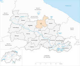
| Location of the municipality | |
  |
|
Berg is a municipality and a town in the district of Weinfelden the canton of Thurgau in Switzerland . The existing since 1995 municipality includes the former Munizipalgemeinde mountain with their former congregations Mountain, Andhausen , Graltshausen and Moors and the earlier the former Munizipalgemeinde Birwinken counting local church Guntershausen bei Birwinken .
geography
The political municipality Berg consists of the following localities:
- The former municipality of Berg TG is a scattered settlement on the Ottenberg, located on the Kreuzlingen - Weinfelden road and is structured as follows: In the north-west is the district of Bergerwilen and in the south, Kehlhof. Beckelswilen in the north-west, Heimenlachen in the north and Hohenalber in the north-east also belong to Berg. Berg Castle became known through letters and a poem by Annette von Droste-Hülshoff . The last Count of Thurn zu Berg, Johann von Thurn and Valsassina, was a member of the government of the Canton of Thurgau from 1817 to 1831.
- Andhausen is located to the east of Berg and has grown together with Berg due to the ongoing construction boom.
- The rural village of Graltshausen is located at the northeastern end of Berg. This also includes the hamlets of Ast near Graltshausen and Lanzendorn. Ast used to belong to the local community of Oberhofen bei Kreuzlingen , was separated and in 1998 assigned to the political community of Berg.
- Guntershausen bei Berg lies below Andhausen and is best known in the region for the old people's home.
- The southern village of Mauren on the slope of the Ottenberg is an important transit point for individual traffic. The Unterhard district is located on the municipal border with Weinfelden, whereas Mittelhard and Oberhard already belong to Weinfelden.
The former local community of Weerswilen , which used to belong to the former municipality of Berg , has belonged to Weinfelden since 1995.
history

There are traces of settlement from the Stone Age and litter finds from the Bronze Age . In the early Middle Ages, Berg and the surrounding area were owned by the Bishop of Constance and were located on the southern border of the Bischofshöri . It was mentioned as Berga from the year 796 . As a forerunner of the castle built around 1600, a fortification system from the 12th / 13th centuries is being used. Century. The castle and jurisdiction with the villages of Berg, Andhausen and Donzhausen as well as parts of Andwil , Mauren and Mattwil were given as fiefs by the cathedral monastery of Konstanz until 1798 . The separation from the diocese administration and the emergence of the judicial rule documented from 1386 are unclear. Court lords were u. a. the Egli von Zug (1518–1567), the Brümsi von Herblingen (1586–1653 / 56) and that of Thurn-Valsassina (1676–1798).
In 1506 a benefice was donated to the Mauritius altar of the chapel, which was probably built in the 11th century, so that a chaplain could be employed in Berg, a branch of Sulgen . After the Reformation in 1529, to which the residents adhered while the judiciary remained in Catholic hands, there was no regular service until 1575. Until the reformed parish was founded in 1851 with Berg, Andhausen, Mauren and Weerswilen, Berg was supplied from Sulgen. The in 16./17. The Catholic parish , which was established in the 19th century, also included Altishausen , Birwinken, Dotnacht, Graltshausen, Guntershausen, Hugelshofen and Mattwil. In 1935 parity was lifted and a Catholic church was built.

The most important branches of agriculture were fruit growing (distillery), cattle farming and until 1900 viticulture. A cheese dairy was established in 1899. As a result of industrialization , the Brauchli brickworks were established in Berg around 1865 and several embroidery factories around 1900. In 1911 it was connected to the Mittelthurgau Railway with the Kehlhof and Berg stations. In recent times, a favorable tax rate and the attractive location have led to strong population growth and the development of new residential areas. In 1990 45% of those employed in Berg worked in the second and third economic sectors .
In 1993 the local community Andhausen was incorporated into the local community Berg. In 1995, the local churches Berg, Graltshausen, Moors, by the United Munizipalgemeinde Birwinken separated municipality Guntershausen bei Birwinken and separated from the local church Weerswilen district Beckel Wilen on political community Berg. As early as 1866, the former municipality of Graltshausen was separated from the municipality of Hugelshofen and assigned to the municipality of Berg.
→ see also the history sections in the articles Andhausen , Graltshausen , Guntershausen bei Berg and Mauren TG
coat of arms
Blazon : A white tower in red .
The coat of arms goes back to that of the von Thurn family. The local community Berg used the coat of arms since 1947. In the run-up to the formation of the political community Berg it was decided to continue using this coat of arms.
population
 |
| 1850 | 1910 | 1950 | 1980 | 1990 | 2000 | 2010 | 2018 | |
|---|---|---|---|---|---|---|---|---|
| Political community | 2876 | 3067 | 3406 | |||||
| Municipal parish | 1374 | 1767 | 1690 | 1953 | 2517 | |||
| Local parish | 440 | 833 | 795 | 1142 | 1575 | |||
| source | ||||||||
Of the total of 3,406 inhabitants in the municipality of Berg in 2018, 472 or 13.9% were foreign nationals. 1651 (48.5%) were Protestant Reformed and 902 (26.5%) were Roman Catholic. The village of Berg had 2447 residents at that time.
economy
In 2016, Berg offered work for 1,156 people (converted to full-time positions). 8.4% of them were employed in agriculture and forestry, 28.3% in industry, trade and construction and 63.3% in the service sector.
traffic
The community lies in the triangle of the three regional centers Amriswil , Kreuzlingen and Weinfelden and is well connected to public transport. The two railway stations Berg and Kehlhof are located in the municipality on the Konstanz – Weinfelden route of the former MThB.
Attractions
The hamlet of Unterhard is listed in the inventory of places worth protecting in Switzerland .
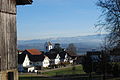
Mountain, view from the castle towards the reformed church

St. Mauritius Catholic Church

reformed Church

Schloss Berg retirement and nursing home

Commercial building in the center of Berg

"Hardmüli" in Unterhard

Farmhouse in Unterhard


Partner communities
-
 Królik Polski (Partnership of the Berg Catholic Parish)
Personalities
- Caroline Farner (1842–1913), doctor
- Ernst Leumann (1859–1931), Indologist
- Hans Straub (1895–1962), civil engineer
- Heinz Haffter (1905–1998), classical philologist
- Hermann Lei (* 1937), politician
- Timon Altwegg (* 1967), Swiss pianist
- Markus Nüssli (* 1971), bobsleigh driver, silver medalist, Nagano 1998
- Anita Buri (* 1978), Miss Switzerland 1999
Web links

Individual evidence
- ↑ Permanent and non-permanent resident population by year, canton, district, municipality, population type and gender (permanent resident population). In: bfs. admin.ch . Federal Statistical Office (FSO), August 31, 2019, accessed on December 22, 2019 .
- ↑ a b Thurgau in figures 2019 . On the website of the Statistical Office of the Canton of Thurgau (PDF file; 1.8 MB), accessed on April 28, 2020.
- ↑ Swiss land use statistics. Completed on July 1, 1912. Published by the Federal Statistical Bureau. ( Memento from April 12, 2016 in the Internet Archive )
- ↑ a b Localities and their resident population. Edition 2019 . On the website of the Statistical Office of the Canton of Thurgau (Excel table; 0.1 MB), accessed on April 28, 2020.
- ↑ Rolf Soland, Romanshorn: "The last Count of Thurn zu Berg"
- ↑ a b c d population development of the municipalities. Canton Thurgau, 1850–2000 and resident population of the municipalities and change from the previous year. Canton of Thurgau, 1990–2018. On the website of the Statistical Office of the Canton of Thurgau (Excel tables; 0.1 MB each), accessed on April 28, 2020.
-
↑ a b c d e Gregor Spuhler : Berg (TG). In: Historical Lexicon of Switzerland . These sections are largely based on the entry in the Historical Lexicon of Switzerland (HLS), which, according to the HLS's usage information, is under the Creative Commons license - Attribution - Share under the same conditions 4.0 International (CC BY-SA 4.0).
- ↑ StiASG , Urk. I 136. Online at e-chartae , accessed on June 12, 2020.
- ↑ a b municipal coat of arms . On the website of the State Archives of the Canton of Thurgau, accessed on December 8, 2019
Affeltrangen | Amlikon-Bissegg | Mountain | Birwinken | Bischofszell | Bürglen | Bussnang | Alder | Hauptwil-Gottshaus | Hohentannen | Kradolf-Schönenberg | Märstetten | Schönholzerswilen | Sulgen | Weinfelden | Wigoltingen | Wuppenau | Zihlschlacht-Sitterdorf
Former municipalities: Amlikon | Andhausen | Andwil | Bissegg | Bleiken | Bonau | Book at Märwil | Buchackern | Buhwil | Donzhausen | Engishofen | Engwang | Ennetaach | Friltschen | Götighofen | House of God | Graltshausen | Griesenberg | Guntershausen near Birwinken | Heaps | Happerswil book | Hauptwil | Holy Cross | Heldswil | Hessenreuti | Pants jerk | Illhart | Istighofen | Klarsreuti | Kradolf | Kümmertshausen | Lamperswil | Lanterswil | Leimbach | People mark | Märwil | Mattwil | Mettlen | Neukirch an der Thur | Oberbussnang | Opfershofen | Oppikon | Ottoberg | Reuti | Riedt | Rothenhausen | Schönenberg | Swiss wood | Sitterdorf | Strohwilen | Toos | Weerswilen | Zezikon | Zihlschlacht
Canton of Thurgau |
Districts of the Canton of Thurgau |
Municipalities of the Canton of Thurgau