Guntershausen near Berg
| Guntershausen near Berg | ||
|---|---|---|
| State : |
|
|
| Canton : |
|
|
| District : | Weinfelden | |
| Political community : | Mountain TG | |
| Postal code : | 8572 | |
| former BFS no. : | 4903 | |
| Coordinates : | 731 650 / 270500 | |
| Height : | 504 m above sea level M. | |
| Area : | 1.49 km² | |
| Residents: | 155 (December 31, 2018) | |
| Population density : | 104 inhabitants per km² | |
|
Guntershausen in winter 2017 |
||
| map | ||
|
|
||
Guntershausen bei Berg is a village in the municipality of Berg in the Weinfelden district of the canton of Thurgau in Switzerland .
Until 1994 Guntershausen with the name Guntershausen bei Birwinken was a local parish of the municipality of Birwinken . In 1995 Guntershausen separated from the municipality of Birwinken and merged into the political municipality of Berg as part of the Thurgau municipal reform
geography
Guntershausen is located on the southeast slope of the Ottenberg . The Tobelweiher , which is drained by the Tobelbach , and the Mülibach are located on the territory of the former local community .
history
Guntershausen was first mentioned in 1291 under the name Gundhartzhusen . In the early Middle Ages Guntershausen was a so-called baronial bailiwick . Baron Friedrich von Bussnang sold Guntershausen in 1346 to Rudolf Ruch, a citizen of Constance . After a few changes of ownership, the Lower Court was sold to the Bürglen lordship in 1553 , which belonged to the city of St. Gallen from 1579 to 1798 .
Guntershausen, evangelical since the Reformation in 1529, has always belonged to the parish of Sulgen . In the winter of 1769, a first village school was opened in Guntershausen together with Andhausen .
Economy and Infrastructure
A mill that had existed since 1423 was a Konstanz fief and was bought by the Altwegg family. Around 1830 Jakob Farner from Stammheim acquired the mill with sawmill and a large agricultural estate. His youngest daughter Caroline Farner was the second Swiss doctor and first general practitioner. In 1832 the Altwegg family built a small mill operated by the Tobelbach.
In the 19th century, agriculture was practiced, and there was also a forge and a cotton weaving mill . With the transition to dairy farming and fruit growing towards the end of the 19th century, embroidery came to the village. The Mittelthurgau Railway , which opened in 1911 and whose route runs across the municipality, did not result in any structural change.
In 1924 the “ Milchhüttli ” was built, which served as a collection point for milk for the Leimbach-Guntershausen cheese company. Over the years the number of milk suppliers decreased and the building was rented to the telephone administration in 1985. Over time, the “Milchhüttli” became a meeting place for young people and served as a night camp for tramps. In 2003 it was canceled.
Since the construction of several single-family houses from 1960, a private retirement and nursing home in 1965 and the “Seniorendörflis” in 1986, Guntershausen has given up the character of a purely farming village.
coat of arms
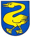
Blazon : A standing yellow swan in blue .
In 1941 Guntershausen got its own municipal coat of arms. The colors yellow and blue come from the barons of Bürglen .
population
| year | 1850 | 1900 | 1930 | 1950 | 1990 | 2000 | 2010 | 2018 |
|---|---|---|---|---|---|---|---|---|
| Local parish | 133 | 105 | 91 | 115 | 169 | |||
| Locality | 197 | 122 | 155 | |||||
| source | ||||||||
Of the total of 155 inhabitants in Guntershausen bei Berg in 2018, 13 or 8.4% were foreign nationals. 72 (46.5%) were Protestant Reformed and 28 (18.1%) were Roman Catholic.
Attractions
A fire brigade syringe purchased in 1877 can be viewed in the Kradolf Fire Brigade Museum .
Personalities
- Caroline Farner (1842–1913), Switzerland's first general practitioner
Web links
Individual evidence
- ↑ Swiss land use statistics. Completed on July 1, 1912. Published by the Federal Statistical Bureau. ( Memento from April 12, 2016 in the Internet Archive )
- ↑ a b c d Localities and their resident population. Edition 2019 . On the website of the Statistical Office of the Canton of Thurgau (Excel table; 0.1 MB), accessed on April 28, 2020.
- ↑ Population development of the municipalities. Canton of Thurgau, 1850-2000. On the website of the Statistical Office of the Canton of Thurgau (Excel table; 0.1 MB), accessed on April 28, 2020.
-
↑ a b c d e
Verena Rothenbühler: Guntershausen near Berg. In: Historical Lexicon of Switzerland .
These sections are largely based on the entry in the Historical Lexicon of Switzerland (HLS), which, according to the HLS's usage information, is under the Creative Commons license - Attribution - Share under the same conditions 4.0 International (CC BY-SA 4.0). - ↑ Caroline Farner 1842–1913. A woman makes history. On the website of the municipality of Berg TG, accessed on February 14, 2020.
- ↑ Locations and Settlements Directory. Canton of Thurgau, 2005 edition . On the website of the Statistical Office of the Canton of Thurgau (PDF; 1.7 MB), accessed on April 28, 2020.
- ↑ Locations and Settlements Directory. Canton of Thurgau, 2012 edition. On the website of the Statistical Office of the Canton of Thurgau (PDF; 3.4 MB), accessed on May 11, 2020.
Remarks
- ↑ with outside courtyards


