
Amlikon-Bissegg
| Amlikon-Bissegg | |
|---|---|
 |
|
| State : |
|
| Canton : |
|
| District : | Weinfelden |
| BFS no. : | 4881 |
| Postal code : | 8514 |
| UN / LOCODE : | CH BEG (Bissegg) |
| Coordinates : | 721 253 / 269 684 |
| Height : | 422 m above sea level M. |
| Height range : | 406–661 m above sea level M. |
| Area : | 14.46 km² |
| Residents: | 1346 (December 31, 2018) |
| Population density : | 93 inhabitants per km² |
| Website: | www.amlikon-bissegg.ch |
| Location of the municipality | |
  |
|
Amlikon is a municipality and a town in the district of Weinfelden the canton of Thurgau in Switzerland . The community was established in 1995 as part of the Thurgau community reorganization through the merger of the Amlikon municipality with the local communities of Amlikon, Bissegg , Griesenberg and Strohwilen .
geography
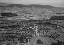
The municipality of Amlikon-Bissegg consists of the parish village of Leutmerken , eleven other localities (Amlikon, Bänikon, Bissegg-Junkholz, Fimmelsberg, Griesenberg, Holzhäusern, Hueb-Vogelsang, Hünikon, Maltbach, Strohwilen and Wolfikon), Weilern (e.g. Tümpfel, Eutenberg, Kreuz, Hofen) and individual farmsteads (e.g. Holzhof, Neuhof, Ziegelhütte, Altenburg).
The rural community is located on the eastern foothills of the Wellenberg and south of the Thur , only about 5% are on the opposite side of the river. The landscape in the north is characterized by the alluvial Thur plain, which is partly used for gravel extraction. The southern part lies in a hilly moraine landscape with typical drumlins , z. B. in the area around the Bissegg, where gravel and clay are also mined. Some brooks cut deep into the ground moraine , especially east of the cantonal road Märstetten - Wil , and the Molasse rock roughly west of the cantonal road drain the municipality to the north towards the Thur. The Griesenbergtobel is the deepest valley in the canton. There are over a dozen ponds and ponds along various streams. In the municipality of Amlikon-Bissegg, the center of the canton of Thurgau is on the Rossweid between Bissegg and Hünikon.
The lowest point of the community is on the Thur at the customs house at 414 m above sea level. M. , while the Dreigemeindestein Amlikon-Bissegg / Hüttlingen / Thundorf near Märwilen the highest point at 642 m above sea level. Damn.
history
→ see sections history in the articles Amlikon , Bissegg , Griesenberg , Leutmerken and Strohwilen
coat of arms


Blazon : oblique split of yellow with black bears head and blue with yellow boat , pale as covered by two yellow rowing, all covered by red-white split oblique beams .
The ship is reminiscent of the earlier Thurfähre in Amlikon, the Bears head to the former relations of the territory to Bissegg the monastery of St. Gallen . The colors yellow and blue go back to the coat of arms of the Lords of Griesenberg , the colors white and red to the Reichenau Abbey , which gave fiefs in the Strohwilen area .
The coat of arms of Amlikon-Bissegg was created by combining elements from the coats of arms of the former local communities Amlikon and Bissegg, which gave the new community its name. Griesenberg and Strohwilen are represented by their colors. In 2003 the community assembly approved the new coat of arms.
population
 |
| 1850 | 1900 | 1960 | 1970 | 1990 | 2000 | 2010 | 2018 | |
|---|---|---|---|---|---|---|---|---|
| Amlikon-Bissegg municipality | 1199 | 1259 | 1341 | |||||
| Amlikon municipality | 1181 | 1097 | 1033 | 990 | 963 | |||

Of the total of 1,341 inhabitants in the municipality of Amlikon-Bissegg in 2018, 137 or 10.2% were foreign nationals. 578 (43.1%) were Protestant Reformed and 323 (24.1%) were Roman Catholic.
The village of Amlikon-Bissegg had 1,443 inhabitants in the same year. 102 of them (including Maltbach) belonged to the Affeltrangen community .
traffic
Amlikon is 3 kilometers from Märstetten, which has an exit from the T14 motorway slip road and a train station on the Winterthur – Romanshorn railway line . The community is stelbst from the post bus line Frauenfeld - Thundorf TG - Weinfelden developed. In addition, the Amlikon airfield has been operated in the Thur foreland since 1963 .
economy
In 2016 Amlikon-Bissegg offered 376 jobs (converted to full-time positions). Of these, 27.6% were employed in agriculture and forestry, 33.0% in industry, trade and construction and 39.4% in the service sector.
Attractions
Amlikon has a village square with picturesque half-timbered buildings . Griesenberg and the hamlet of Leutmerken are listed in the inventory of places worthy of protection in Switzerland .
→ See also the Sights section in the articles Amlikon , Bissegg , Griesenberg and Leutmerken
→ see also the list of cultural assets in Amlikon-Bissegg
Personalities
→ see sections Personalities in the articles Bissegg and Griesenberg
Web links
Individual evidence
- ↑ Permanent and non-permanent resident population by year, canton, district, municipality, population type and gender (permanent resident population). In: bfs. admin.ch . Federal Statistical Office (FSO), August 31, 2019, accessed on December 22, 2019 .
- ↑ a b Thurgau in figures 2019 . On the website of the Statistical Office of the Canton of Thurgau (PDF file; 1.8 MB), accessed on April 28, 2020.
- ↑ a b c Localities and their resident population. Edition 2019 . On the website of the Statistical Office of the Canton of Thurgau (Excel table; 0.1 MB), accessed on April 28, 2020.
-
^ HLS: Amlikon-Bissegg. In: Historical Lexicon of Switzerland .
This section is largely based on the entry in the Historical Lexicon of Switzerland (HLS), which, according to the HLS's usage information, is under the license Creative Commons - Attribution - Share under the same conditions 4.0 International (CC BY-SA 4.0). - ↑ a b Figures / Facts. On the website of the municipality of Amlikon-Bissegg, accessed on November 29, 2019
- ↑ a b c municipal coat of arms . On the website of the State Archives of the Canton of Thurgau, accessed on December 8, 2019
- ^ Community merger in the canton of Thurgau: Amlikon-Bissegg. On the website of the Swiss Coats of Arms and Flags Foundation, accessed on December 20, 2019
- ↑ a b Population development of the municipalities. Canton Thurgau, 1850–2000 and resident population of the municipalities and change from the previous year. Canton of Thurgau, 1990–2018. On the website of the Statistical Office of the Canton of Thurgau (Excel tables; 0.1 MB each), accessed on April 28, 2020.
Affeltrangen | Amlikon-Bissegg | Mountain | Birwinken | Bischofszell | Bürglen | Bussnang | Alder | Hauptwil-Gottshaus | Hohentannen | Kradolf-Schönenberg | Märstetten | Schönholzerswilen | Sulgen | Weinfelden | Wigoltingen | Wuppenau | Zihlschlacht-Sitterdorf
Former municipalities: Amlikon | Andhausen | Andwil | Bissegg | Bleiken | Bonau | Book at Märwil | Buchackern | Buhwil | Donzhausen | Engishofen | Engwang | Ennetaach | Friltschen | Götighofen | House of God | Graltshausen | Griesenberg | Guntershausen near Birwinken | Heaps | Happerswil book | Hauptwil | Holy Cross | Heldswil | Hessenreuti | Pants jerk | Illhart | Istighofen | Klarsreuti | Kradolf | Kümmertshausen | Lamperswil | Lanterswil | Leimbach | People mark | Märwil | Mattwil | Mettlen | Neukirch an der Thur | Oberbussnang | Opfershofen | Oppikon | Ottoberg | Reuti | Riedt | Rothenhausen | Schönenberg | Swiss wood | Sitterdorf | Strohwilen | Toos | Weerswilen | Zezikon | Zihlschlacht
Canton of Thurgau |
Districts of the Canton of Thurgau |
Municipalities of the Canton of Thurgau