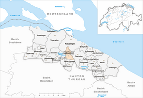
Dippishausen-Oftershausen
| Dippishausen-Oftershausen | ||
|---|---|---|
| State : |
|
|
| Canton : |
|
|
| District : | Kreuzlingen | |
| Political community : | Kemmental | |
| Postal code : | 8573 | |
| former BFS no. : | 4633 | |
| Coordinates : | 730 191 / 275 306 | |
| Height : | 540 m above sea level M. | |
| Area : | 2.65 km² | |
| Residents: | 121 (1980) | |
| Population density : | 46 inhabitants per km² | |
|
Dippishausen |
||
| map | ||
|
|
||
Dippishausen-Oftershausen was a local community in the canton of Thurgau in Switzerland until 1984 . It belonged to Munizipalgemeinde Alterswilen and included the on Route Sulgen - Kreuzlingen nearby hamlet Dippishausen, Oftershausen and Bätershausen.
The local community was called Oftershausen in the 19th century. In 1900 the name was first changed to Dippishausen , and in 1953 it was finally renamed Dippishausen-Oftershausen . In 1984 she joined the local church Siegershausen to the 1996 political community Kemmental merged .
history
Dippishausen was first mentioned in 1192 as Tibinshusen , Oftershausen in 1275 as Oftershusen . The municipality was originally in the Konstanz Bischofshöri . While Dippishausen and Oftershausen belonged to the bailiwick of Eggen from the 13th century to 1798 , in the late Middle Ages Bätershausen was part of the rule of the fort , then the court of Siegershausen and thus until 1798 the episcopal superior bailiwick Gottlieben .
The area initially belonged to the parish of St. Stephan in Constance. Since the 13th century, Dippishausen and Oftershausen have always been parishes according to Alterswilen. After the Reformation in 1529, the few Catholics in Kreuzlingen went to church, and since 1831 they have belonged to the parish of Emmishofen . The parish rights over Bätershausen owned from the 13th century on the Kreuzlingen monastery .
Grain cultivation in three tents shaped the rural community. From the middle of the 19th century the transition to cattle and dairy farming took place. Between 1967 and 1887 the goods were merged.
population
| year | 1850 | 1900 | 1950 | 1980 | 2000 | 2010 | 2018 |
| Local parish | 140 | 118 | 140 | 121 | |||
| Dippishausen | 14th | 14th | 11 | ||||
| Oftershausen | 57 | 42 | 45 | ||||
| Batershausen | 34 | 52 | 63 | ||||
| source | |||||||
Attractions
Web links
Individual evidence
- ↑ Swiss land use statistics. Completed on July 1, 1912. Published by the Federal Statistical Bureau. ( Memento from April 12, 2016 in the Internet Archive )
-
↑ a b c d e f André Salathé: Dippishausen-Oftershausen. In: Historical Lexicon of Switzerland .
These sections are largely based on the entry in the Historical Lexicon of Switzerland (HLS), which, according to the HLS's usage information, is under the Creative Commons license - Attribution - Share under the same conditions 4.0 International (CC BY-SA 4.0). - ↑ Locations and Settlements Directory. Canton of Thurgau, 2005 edition . On the website of the Statistical Office of the Canton of Thurgau (PDF; 1.7 MB), accessed on April 28, 2020.
- ↑ Locations and Settlements Directory. Canton of Thurgau, 2005 edition . On the website of the Statistical Office of the Canton of Thurgau (PDF; 1.7 MB), accessed on April 28, 2020.
- ↑ Locations and Settlements Directory. Canton of Thurgau, 2012 edition. On the website of the Statistical Office of the Canton of Thurgau (PDF; 3.4 MB), accessed on May 11, 2020.
- ↑ List of settlements. Canton of Thurgau, edition 2019 . On the website of the Statistical Office of the Canton of Thurgau (Excel table; 0.2 MB), accessed on May 10, 2020.


