
Baar ZG
| ZG is the abbreviation for the canton of Zug in Switzerland and is used to avoid confusion with other entries of the name Baar . |
| Baar | |
|---|---|
 |
|
| State : |
|
| Canton : |
|
| District : | No district division |
| BFS no. : | 1701 |
| Postal code : | 6319 ( Allen Winds ) 6340–6342 (Baar) |
| UN / LOCODE : | CH BAR |
| Coordinates : | 682 427 / 227780 |
| Height : | 443 m above sea level M. |
| Height range : | 420–841 m above sea level M. |
| Area : | 24.85 km² |
| Residents: | 24,468 (December 31, 2018) |
| Population density : | 985 inhabitants per km² |
|
Proportion of foreigners : (residents without citizenship ) |
28.9% (December 31, 2,015) |
| Mayor : | Walter Lipp (CVP Baar) |
| Website: | www.baar.ch |
 View of Baar |
|
| Location of the municipality | |
  |
|
Baar is a municipality in the canton of Zug in Switzerland .
geography
Baar is located north of the city of Zug at 443 m above sea level. The Lorze flows around M. Baar from east to west in a large arc, which rises in the Ägerisee and flows into the Zugersee , from which it flows further into the Reuss . The local mountain is the northeastern Baarburg .
Localities
The center of the municipality of Baar is the village of the same name, the extensive municipal area also includes the three settlements Allenwind, Blickensdorf and Inwil, the hamlet of Deinikon and other individual farms.
- Allen winds
- The village of Allen winds ( 705 m above sea level ) is located southeast of Baar am Zugerberg and is the home of around 1,250 people.
- Blickensdorf
- The village of Blickensdorf ( 441 m above sea level ) is north-west of Baar, across the Lorze . It was the birthplace of the future Zurich military leader and mayor Hans Waldmann (1435–1489) (Hans-Waldmann-Haus in the center of the village). About 2000 people live here.
- Deinikon
- The hamlet of Deinikon consists of a group of individual farms and is located on the plain north of Baar and on the western slope up to the Deibüel farm.
- Inwil near Baar
- The village of Inwil ( 443 m above sea level ) is located southeast of Baar at the foot of the Zugerberg, in close proximity to the city of Zug . Around 4,000 people currently live here.
- Neuägeri
- The majority of the scattered settlement Neuägeri belongs to the municipality of Unterägeri with smaller parts of the municipalities of Baar - at their southeasternmost tip - Menzingen and Zug. The hamlet is on the main road Unterägeri – Zug, which runs parallel to the Lorze in this section and forms a local traffic junction.
- Sihlbrugg village
- The hamlet of Sihlbrugg is a road traffic junction and is spread over the four communities of Neuheim , Baar, Hausen am Albis and Horgen . It is located on the Baarerboden, northeast of Baar and the Walterswil farm, on the other side of the watershed between Sihltal and Lorzetal. The Silhbrugg Station is a few kilometers north on the SBB Thalwil-Zug route between the Albis and Zimmerberg tunnels and is the starting and ending point of the Sihltalbahn (via Adliswil to Zurich). Few people live here, mainly car garages, businesses and offices are located here.
- Walterswil
- Hof Walterswil ( 513 m above sea level ) is located on Baarerboden, northeast of Baar and north at the foot of the Baarburg . The farm was bought by the Wettingen monastery in 1629 and expanded into a regionally important bath, which existed for over 200 years and was also a place of pilgrimage to Mary . Today there is a larger international school here.
Flora and fauna
The forests of the municipality of Baar are mixed forests , the best known are the Baarburg and the Wildenburg . The Baarburg is northeast of the city center, the Wildenburg in the southeast near the village of Allen winds .
A very large forest is the Lorzentobel , which stretches along the Lorze. Other forests are the Ruggeren, the Hintersattel, the Chugelrüti, Hegi, the Deiniker Forest, the Schönbüelwald and parts of the Steinhausenerwald. There are also numerous smaller forests, such as the Bachtalen.
The fauna of the municipality of Baar corresponds to that of the rest of the canton of Zug .
history


The oldest traces found by settlers in Baar are over 4,700 years old. It is a pit house from the Cord Ceramic culture . As early as 500 BC The Celts traded with the Mediterranean in this region. They built their settlement on the Baarburg. This was protected with a wood-earth wall. In the years 100 BC From BC to AD 400, Roman culture had a strong influence on Baar. This is evidenced by the St. Martin Church in the center of Baar, which still exists today, and several finds such as Roman coins and relics of hypocausts . Alemanni immigrated to the region in the 6th and 7th centuries . In the centuries that followed, Baar was increasingly Christianized.
Around 1200 the Hünenbergers , who were feudal lords of the Habsburgs , began building the Wildenburg. From there they controlled the Baar region. In 1228 the Habsburgs sold the Baar farm to the Kappel am Albis monastery . 80 years later, the Lords of Hünenberg bought the Baar tower, which no longer exists today and has been immortalized on the municipal coat of arms since 1942. In 1352 Baar joined the Confederation . Hans Waldmann , who later became known as the military leader and mayor of Zurich, was born in Blickensdorf in 1435. Many buildings are still named after him today, for example the “Waldmannhalle”, the “Restaurant Hans Waldmann” (demolished) and the “Hans-Waldmannstrasse”.
In the 16th century, Baar was shaped by the religious unrest that was triggered by the Reformation. In 1526 Baar bought himself out of the Kappel monastery. Three years later the first Kappel War broke out between the Protestant and Catholic towns in Switzerland. The conflict was settled with a milk soup ("Kappeler Milchsuppe"). Around two years later, however, the conflict broke out again and the second Kappel War broke out . While the first war was peaceful, the second war led to acts of war. On October 11, 1531 Ulrich Zwingli , the leader of the Reformed, fell in the battle of Kappel and on October 24 there was the decisive battle on the Gubel, in which the Catholics were victorious. Less than a month later, a peace treaty was signed between the opposition. The peace cross in Deinikon is still a reminder today.
coat of arms
Baar was the first municipality in the canton to have its own seal . It can be found on a file in the canton archive dated November 19, 1738 and shows the canton shield with the majuskel B. Later a larger seal with the same coat of arms appears; this stamp is still present today and is owned by the community . Today's coat of arms is more recent and was designed by Eugen Hotz. The community assembly on August 9, 1942 approved the new creation. The municipal assembly of May 17, 1942 authorized the municipal council to adopt the coat of arms approved by the community.
- Split; in front in gold (yellow) a black tower with three battlements, behind in blue a floating silver (white) patriarchal cross / Lorraine cross
The tower refers to the coat of arms of the Lords of Baar, the cross to the symbol of the tower of the parish church of St. Martin.
population
| Population development | ||||
|---|---|---|---|---|
| year | Residents | year | Residents | |
| 1743 | 1,831 | 1963 | 10,000 | |
| 1749 | 1,767 | 1970 | 14,074 | |
| 1798 | 1,757 | 1973 | 15,000 | |
| 1850 | 2,346 | 1980 | 15,092 | |
| 1860 | 3,323 | 1990 | 16'049 | |
| 1900 | 4,484 | 2000 | 19'057 | |
| 1950 | 6,992 | 2003 | 20,000 | |
| 1960 | 9,114 | 2010 | 21,787 | |
At the end of April, the population was 24,094. The proportion of foreigners was 30.8%.
57% of the population are Roman Catholic, 14% Protestant Reformed, 13% are non-denominational and 16% have a different faith (mostly Orthodox Christians and Muslims).
politics
Municipal council
The municipal council consists of seven members and is set up as follows:
- Walter Lipp (CVP): Mayor; Presidential / Culture
- Zari Dzaferi (SP): Security / Works Service
- Sonja Zeberg (FDP): real estate / sport
- Sylvia Binzegger (CVP): School President
- Jost Arnold (FDP): planning / construction
- Pirmin Andermatt (CVP): Finance / Economy
- Berty Zeiter ( ALG ): Social / Family
Cantonal elections
In the 2018 cantonal elections in the canton of Zug, the share of the vote in Baar was: SVP 24.5%, CVP 22.3%, SP 18.1%, FDP 17.1%, GPS and CSP 9.3%, glp 5.2% , Action by Independent Citizens 3.4%.
National Council elections
In the 2019 Swiss parliamentary elections, the share of the vote in Baar was: SVP 28.2%, CVP 22.7%, GPS 19.7%, FDP 13.3%, SP 16.0%, glp 3.4%.
economy
Baar is the headquarters of the globally operating raw materials trading company Glencore and the headquarters of the Danzer Group administration . The ski and binding manufacturer Völkl , together with its subsidiary Marker, is based in Baar. In addition, the hairdressing chain Gidor , the IT company Veeam Software and the global medical technology company Schiller AG have their headquarters in this municipality.
Other local companies include Royal Dutch Shell , Sika AG , Vermögensberater Partners Group , real estate company Alfred Müller AG and beverage manufacturer Red Bull .
traffic
The Zurich – Zug section of Hauptstrasse 4 runs through Baar . To the north-west of Baar, the A4a autobahn , which begins at Walterswil at Hauptstrasse 4, runs along the former line of the Lorze river in the municipality ; It leaves the municipality west of Baar at the motorway junction of the same name.
The station of the same name, located in the middle of the town of Baar, is on the Thalwil –Zug railway line , which was opened in 1897 by the Swiss Northeast Railway (NOB) as part of the Zurich Gotthard Railway. The line branches off the left bank Seebahn in Thalwil and reaches Baar via Sihlbrugg Station in the north through the single-lane Albis Tunnel ; in the south, the route leads to Zug train station . The station (including the routes) was transferred to the Swiss Federal Railways (SBB ) in 1902 and is now served by trains of the Zurich S-Bahn (since 1990) and the Zug urban railway (since December 2004). Together with the start of operations of the Zug light rail, the two stops Baar Neufeld and Baar Lindenpark were also built in the municipality . In 2007 the old station building was replaced by a modern one.
Zugerland Verkehrsbetriebe has operated regional bus transport since 1951 . The predecessor company, Electric Strassenbahnen im Kanton Zug (ESZ), operated an overland tram route between 1913 and 1953, which Baar also operated.
education
The municipality of Baar has 14 kindergartens, seven primary schools and two high school houses (Sternmatt 2 and Sennweid). The localities of Inwil and Allenwind each have their own kindergarten and primary school.
The upper school students who attend the grammar school of the Cantonal School Zug have to go to the neighboring municipality of Zug.
Attractions
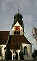
- The Catholic parish church of St. Martin was built in the 14th century. The nave was redesigned in Baroque style from 1771 to 1777. In addition to the late Baroque stucco and ceiling paintings, the interior also features late Gothic wall paintings from the 16th century. The church tower clock was made in 1526 by the Winterthur watchmaker Laurentius Liechti . The holy grave chest, which can be seen today in the Museum Burg in Zug , also comes from the church .
- The St. Anna cemetery chapel has a carved wooden ceiling from 1508. The coats of arms of old Baar families can be seen on the inside of the southern entrance wall. On the northern outer wall of this former ossuary, a representation of the “grateful dead” has been preserved (mid-16th century), but it was restored in 1740 in the style of the time. The mural shows the old cemetery surrounded by a wall and in the middle the ossuary with skulls piled up, in front of which the knight pursued by robbers prays for the deceased. The skeletal dead emerge from the ossuary and the graves, arm themselves with scythes and halberds, and drive away the three robbers.
- The reformed church, built from 1866 to 1867 by Ferdinand Stadler , is in neo-Gothic style.
- The town hall, a half-timbered building over a brick base, was built in 1676.
- The Spinnerei an der Lorze factory with the two main wings from 1852 to 1857 forms a group of buildings that is typical of the early industrialization period.
- The Wildenburg ruins , located southeast of Baar, were one of the seats of the Knights of Hünenberg and were destroyed in the 14th century.
- The pilgrimage chapel of St. Wendelin in the Allen wind district was built in 1594.
- The Höllgrotten are a show cave near Baar.
- The Baar brewery produces black beer , wheat beer and corn beer .
Picture gallery
Catholic Church of Saint Martin

reformed Church

Holy Cross Chapel

town hall

Baar Brewery


Personalities
sons and daughters of the town
- Joseph Leonz Andermatt (1740–1817), General of the Helvetic Republic
- Martin Andermatt (* 1961), football coach
- Julius Bessmer (1864–1924), Jesuit priest and university professor
- Nicolas Bisig (* 1982), musician and rapper Fratelli-B
- Raphael Diaz (* 1986), ice hockey player
- Jannik Fischer (* 1990), ice hockey player
- Rainer E. Gut (* 1932), bank manager
- Annemarie Huber-Hotz (1948–2019), politician (FDP) and Switzerland's first female chancellor
- Max Huber (1919–1992), graphic artist
- Manu Koch (* 1972), jazz musician
- Erich Langjahr (* 1944), film director
- Ernst Lüthold (1904–1966), composer
- Brigitte McMahon (* 1967), triathlete
- Moreno Merenda (* 1978), football player
- Patrick De Napoli (* 1975), national soccer player
- Marcel Rohner (* 1964), bobsledder
- Martin Schmid (Jesuit) (1694–1772), missionary, musician and master builder
- Rolf Schweiger (* 1945), politician and lawyer
- Alois Strickler (1924–2019), mountaineer
- Markus Uhr (* 1974), artist
- Hanspeter Uster (* 1958), politician
- Manfred Züfle (1936–2007), publicist and writer
Personalities who have worked on site
- Otto Beisheim (1924–2013), founder of the Metro Group, patron
- Beat Villiger (* 1957), politician (CVP), councilor
Others
A conflict over the 380 kV Benken-Mettlen line has been simmering for years . Landowners, local politicians and other villagers are calling for the high-voltage line to be laid underground, but the operators EWZ and NOK reject this.
literature
- Linus Birchler : The art monuments of the canton of Zug, Volume I: Introduction and Zug-Land. (= Art Monuments of Switzerland. Volume 5). Edited by the Society for Swiss Art History GSK. Bern 1934.
Web links
- Official website of the municipality of Baar
- Lorze industrial path
- Renato Morosoli: Baar (ZG). In: Historical Lexicon of Switzerland .
- Baar ZG on the ETHorama platform
Individual evidence
- ↑ Permanent and non-permanent resident population by year, canton, district, municipality, population type and gender (permanent resident population). In: bfs. admin.ch . Federal Statistical Office (FSO), August 31, 2019, accessed on December 22, 2019 .
- ↑ Latest annual results ( Memento from January 1, 2015 in the Internet Archive )
- ↑ Baar Online: Baar in numbers
- ^ Elections to the Cantonal Council. Retrieved August 7, 2020 .
- ^ Federal Statistical Office : NR - Results parties (municipalities) (INT1). In: Federal Elections 2019 | opendata.swiss. August 8, 2019, accessed August 1, 2020 .
- ^ Josef Grünenfelder: Parish church of St. Martin and ossuary chapel of St. Anna in Baar. (Swiss Art Guide, No. 832, Series 84). Ed. Society for Swiss Art History GSK. Bern 2008, ISBN 978-3-85782-831-7 .
- ↑ Hans Georg Wehrens: The dance of death in the Alemannic language area. «I have to do it - and don't know what» . Schnell & Steiner, Regensburg 2012, ISBN 978-3-7954-2563-0 . P. 42 f.
Baar | Cham | Hünenberg | Menzingen | Neuheim | Oberägeri | Risch | Steinhausen | Unterägeri | Walchwil | train
Canton of Zug | Districts | Municipalities of the canton of Zug