
Unterägeri
| Unterägeri | |
|---|---|
 |
|
| State : |
|
| Canton : |
|
| District : | No district division |
| BFS no. : | 1709 |
| Postal code : | 6314 |
| UN / LOCODE : | CH UTR |
| Coordinates : | 686 939 / 221512 |
| Height : | 727 m above sea level M. |
| Height range : | 685–1578 m above sea level M. |
| Area : | 25.61 km² |
| Residents: | 8868 (December 31, 2018) |
| Population density : | 346 inhabitants per km² |
|
Proportion of foreigners : (residents without citizenship ) |
24.7% (December 31, 2,015) |
| Mayor : | Josef Ribary ( FDP ) |
| Website: | www.unteraegeri.ch |
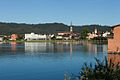
 Unterägeri and See 2010 |
|
| Location of the municipality | |
  |
|
Unterägeri is a municipality in the canton of Zug in Switzerland .
geography
Unterägeri is located at the western end of Lake Aegeri (lake level 724 m above sea level ) on the course of the Lorze , southeast of the city of Zug . The old village (Oberdorf) is located at the foot of the Wilerberg, a little further away from the lake outflow, on the old road from Zug to Schwyz ( Hauptstrasse 381 ). Since the middle of the 20th century, the village has developed into a residential area for the majority of the population who work in the nearby urban agglomerations.
Waters
The Ägerisee is located in the Ägerital and of course borders on Unterägeri. The Hüribach comes from the Hürital and flows into the lake and at the Birkenwäldli it flows out of the lake as Lorze.
Today, the Ägerisee is the only Swiss body of water where the rafting tradition is still alive. At unspecified intervals - but usually every three years - this tradition is celebrated with a large rafting festival. Nature lovers, tourists and wood experts from all over Switzerland and the neighboring countries come to the Ägerital to attend the rare festival with its many attractions and cultural highlights.
history
The political community Unterägeri has only existed since 1798. The history of Unterägeri, formerly called Wilägeri or Wilen, begins earlier.
The traces of human settlement in the Aegerital can be traced back to around 2000 BC. Traced back to the Neolithic . Place and field names, as well as isolated archaeological finds give clues to the earliest inhabitants. In the 6th century, the Alemanni invading Switzerland from the north settled the Aegeri valley. The Ägerital changed hands several times and belonged to parts of the Fraumünster monastery in Zurich, the Einsiedeln monastery and the Habsburgs .
On November 15, 1315, Habsburg troops moved from Zug up the Aegeri valley against the Confederates . At Morgarten am Ägerisee there was finally the Battle of Morgarten , which ended with a devastating defeat for the Habsburgs. In 1352 the city and office of Zug and with it the Aegerital joined the Confederation, but it was not until the end of the 17th century that the people of the Aegerital were free from all Habsburg and monastic claims to property. The ecclesiastical and political detachment of Unterägeris from Oberägeri followed . Therefore, from 1856 onwards, a church was built according to plans by Ferdinand Stadler .
Industrialization began in Unterägeri in the 19th century, using the water power of the Lorze. With industrialization, the population increased sharply. The development of Unterägeri into a health resort towards the end of the 19th century compensated for the slow decline of the industry.
During the Second World War Unterägeri was on the Reduit border . The Unterägeri barrier was built to defend this entrance to the Reduit.
After the Second World War, after a long period of stagnation, population growth began again, so that the population of Unterägeri doubled in the second half of the 20th century.
In September 2017 Unterägeri was certified as an energy city for the fourth time .

Attractions
- Catholic Church Holy Family
- Catholic Marienkirche (old parish church)
- Holy Trinity Chapel
photos
Unterägeri

Arch bridge over the Lorze

Way to the beach path

Village schoolhouse

Parish church

Marienkirche

Trinity Chapel Mittenägeri with hermit house


Personalities
- Meinrad Henggeler (1792–1869), entrepreneur and liberal politician
- Alois Henggeler (1807–1888), entrepreneur and liberal politician
- Wolfgang Henggeler (1814–1877), entrepreneur and liberal politician
- August Henggeler (1848–1929), entrepreneur and liberal politician
- Meinrad Iten (1867–1932), painter
- Peter Hess (* 1948), politician (CVP), President of the National Council 2000/01 and lawyer
- Martin B. Lehmann (1963–2011), politician (SP)
- Marcel Aregger (* 1990), racing cyclist
literature
- Linus Birchler : The art monuments of the canton of Zug, Volume I: Introduction and Zug-Land. (= Art Monuments of Switzerland. Volume 5). Edited by the Society for Swiss Art History GSK. Bern 1934.
Web links
- Official website of the municipality of Unterägeri
- Renato Morosoli: Unterägeri. In: Historical Lexicon of Switzerland .
Individual evidence
- ↑ Permanent and non-permanent resident population by year, canton, district, municipality, population type and gender (permanent resident population). In: bfs. admin.ch . Federal Statistical Office (FSO), August 31, 2019, accessed on December 22, 2019 .
- ↑ Current annual results ( Memento from January 1, 2015 in the Internet Archive )
- ↑ Energiestadt: Unterägeri fact sheet , accessed on October 25, 2017.
- ^ Josef Grünenfelder: Unterägeri ZG. Churches and chapels. (Swiss Art Guide, No. 283). Ed. Society for Swiss Art History GSK. Bern 1980, ISBN 978-3-85782-283-4 .
Baar | Cham | Hünenberg | Menzingen | Neuheim | Oberägeri | Risch | Steinhausen | Unterägeri | Walchwil | train
Canton of Zug | Districts | Municipalities of the canton of Zug