
Schongau LU
| LU is the abbreviation for the Canton of Lucerne in Switzerland and is used to avoid confusion with other entries of the name Schongau . |
| Schongau | |
|---|---|
 |
|
| State : |
|
| Canton : |
|
| Constituency : | Hochdorf |
| BFS no. : | 1041 |
| Postal code : | 6288 |
| Coordinates : | 662 862 / 235613 |
| Height : | 639 m above sea level M. |
| Height range : | 527–878 m above sea level M. |
| Area : | 12.43 km² |
| Residents: | 1039 (December 31, 2018) |
| Population density : | 84 inhabitants per km² |
|
Proportion of foreigners : (residents without citizenship ) |
5.9% (December 31, 2,015) |
| Website: | schongau.ch |
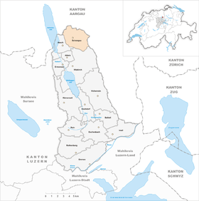
| Location of the municipality | |
  |
|
Schongau is a municipality in the Hochdorf constituency in the canton of Lucerne in Switzerland .
geography
Schongau lies above the Hallwilersee on the northern foothills of the Lindenberg . In the north of the municipality, on the border with the canton of Aargau , is the district of Niederschongau . It consists of the Hinterdorf ( 620 m above sea level ) to the north and the Vorderdorf ( 639 m above sea level ) to the south . In the center of the community is the district of Mettmenschongau ( 671 m above sea level ), east of it Oberschongau ( 745 m above sea level ) with the neighboring hamlet of Chalchtaren ( 776 m above sea level ) to the southeast . The district of Rüdikon ( 663 m above sea level ) is located south of Mettmenschongau . And in the southeast - in a northwest-southeast direction - are the hamlets of Kretzhof ( 754 m above sea level ), Peyerhof ( 791 m above sea level ) and Luckel ( 802 m above sea level ). The Mettmenschongauerbach flows from its source at Kretzhof in a north-westerly direction and crosses the districts of Mettmenschongau and Niederschongau. 70.4% of the municipal area of 1243 ha is used for agriculture. Since only 3.5% of the community area is settlement area, the majority of the remainder consists of forest and wood, which cover 26.1% of the community area.
The neighboring municipalities of Schongau in Lucerne are Aesch and Hitzkirch . In addition, the place borders in the north on the communities Bettwil and Fahrwangen , in the east on Buttwil , which are all in the canton of Aargau.
population
| Population development | |
|---|---|
| year | Residents |
| 1850 | 1,077 |
| 1888 | 802 |
| 1930 | 792 |
| 1950 | 726 |
| 1960 | 734 |
| 1970 | 743 |
| 1980 | 678 |
| 1990 | 669 |
| 2000 | 729 |
| 2010 | 866 |
From 1850 to 1888 the population fell massively as a result of emigration (1850–1888: −25.5%), then remained stable - with the exception of 1930 - and then fell in two steps to the absolute low of 1990 (1930–1990 : −15.5%). Since then, it has grown strongly again (1990–2004: + 20.6%).
languages
In everyday life, the population speaks a highly Alemannic dialect. In the last census in 2000, 97.26% gave German , 1.10% Albanian and 0.55% Serbo-Croatian as their main / everyday language .
Religions - denominations
In the past, all residents were members of the Roman Catholic Church . Leaving the church and immigration results in the following picture: 83.13% of the population are Roman Catholic, 8.92% Evangelical Reformed and 1.10% Orthodox Christians. There are also 2.88% non-denominational and 1.10% Muslim. The Orthodox are ethnic Serbs and Montenegrins , the Muslims of Albanian origin (as of 2000).
Origin - nationality
At the end of 2014, 949 of the 1,004 inhabitants were Swiss and 55 (= 5.5%) foreigners. The population consisted of 94.5% Swiss citizens. At the end of 2014, the foreign residents came from Germany (70.9%), Italy (3.6%) and Serbia including Kosovo (3.6%). 12.7% came from the rest of Europe and 9.1 % came from outside Europe.
history

The remains of Roman buildings have been excavated in Schongau. The community was settled early on. It was first mentioned by name as early as 831, when an Adalbert bequeathed his property in Scongaua to the St. Gallen monastery . It then became the property of the Counts of Lenzburg and later came under the rule of the Habsburgs . The lower jurisdiction exercised the canon monastery Beromünster . Wilhelm von Grünenberg sold the community, then pledged by the Habsburgs, to Sursee in 1415. Five years later, the city of Lucerne took over the rule and Schongau belonged to the Michelsamt Landvogtei until 1798 . From 1798 to 1803 it formed part of the Beromünster district - since the latter year it has been part of the then newly created Hochdorf Office .
politics
Municipal council
The Schongau municipal council consists of five members and is set up as follows:
- Thierry Kramis ( independent ): Mayor , infrastructure, location marketing
- Ruth Keller-Hofstetter ( FDP ): Education, culture, leisure and sport
- Michael Stocker (independent): Public Safety, Environment and Energy
- Herbert Stutz (CVP): Finances and Taxes, Welfare, Guardianship and Health
- Fredy Stutz-Huber (CVP): Building and spatial planning, trade and industry
Cantonal elections
In the 2015 Cantonal Council elections for the Canton of Lucerne, the share of the vote in Schongau was: SVP 37.3%, CVP 37.8%, FDP 13.7%, GPS 7.9%, glp 3.1%, SP 2.5%.
National Council elections
In the 2015 Swiss parliamentary elections, the share of the vote in Schongau was: SVP 41.5%, CVP 27.0%, FDP 12.6%, SP 6.6%, GPS 5.3%, glp 4.7%, BDP 1, 4%, EVP 1.7%.
traffic
The place is connected to the public transport network by the Hitzkirch – Schongau bus line. In Hitzkirch there is a train station on the Lucerne – Lenzburg line . Schongau is located on the side street Aesch LU – Muri AG. The nearest motorway connections are Lenzburg on the A1 in 19 km and Sempach on the A2 in 24 km away.
Attractions
photos

Schoolhouse and municipal administration

school

Parish church and rectory

Old house

Old parish church, today a pilgrimage church


Personalities
- Wilhelm Keller-Jenny (1823–1888), architect, important Catholic church builder, born in Rüdikon
- Eduard Herzog (1841–1924), first Christian Catholic bishop in Switzerland, born in Schongau
documentation
- Regula and Heinz Tobler: As long as the mill is grinding - a village wants to survive. In: SRF 1 DOK , 2017, broadcast May 16, 2018 (50 min).
Web links
- Official website of Schongau
- Community profile of the cantonal statistical office (2018, PDF)
- Waltraud Hörsch: Schongau. In: Historical Lexicon of Switzerland .
Individual evidence
- ↑ Permanent and non-permanent resident population by year, canton, district, municipality, population type and gender (permanent resident population). In: bfs. admin.ch . Federal Statistical Office (FSO), August 31, 2019, accessed on December 22, 2019 .
- ↑ Permanent resident population according to nationality category, gender and municipality ( memento of the original from January 1, 2015 in the Internet Archive ) Info: The archive link was inserted automatically and has not yet been checked. Please check the original and archive link according to the instructions and then remove this notice. (Permanent resident population)
- ↑ Balance of the permanent resident population according to demographic components, institutional structure, nationality and gender (Federal Statistical Office, STAT-TAB)
- ↑ LUSTAT: Community profile of Schongau ( Memento of the original from May 8, 2016 in the Internet Archive ) Info: The archive link was automatically inserted and not yet checked. Please check the original and archive link according to the instructions and then remove this notice.
- ↑ LUSTAT: Community profile of Schongau ( Memento of the original from May 8, 2016 in the Internet Archive ) Info: The archive link was automatically inserted and not yet checked. Please check the original and archive link according to the instructions and then remove this notice.
- ↑ National Council elections 2015: strength of the parties and voter turnout by municipality. In: Results of the National Council elections 2015. Federal Statistical Office, 2016, accessed on June 1, 2016 .
Aesch | Altwis | Ballwil | Emmen | Ermensee | Eschenbach | Hitzkirch | Hochdorf | Hohenrain | Inwil | Rain | Römerswil | Rothenburg | Schongau
Former communities: Gelfingen | Hemicon | Herlisberg | Lieli | Mosen | Müswangen | Retschwil | Richensee | Sulz
Canton of Lucerne | Constituencies of the Canton of Lucerne | Municipalities of the Canton of Lucerne