
Rain LU
| LU is the abbreviation for the canton of Lucerne in Switzerland and is used to avoid confusion with other entries of the name Rain . |
| Rain | |
|---|---|
 |
|
| State : |
|
| Canton : |
|
| Constituency : | Hochdorf |
| BFS no. : | 1037 |
| Postal code : | 6026 |
| Coordinates : | 662 258 / 220160 |
| Height : | 590 m above sea level M. |
| Height range : | 496–642 m above sea level M. |
| Area : | 9.42 km² |
| Residents: | 2807 (December 31, 2018) |
| Population density : | 298 inhabitants per km² |
|
Proportion of foreigners : (residents without citizenship ) |
6.2% (December 31, 2,015) |
| Website: | www.rain.ch |
_234.JPG) Rain LU |
|
| Location of the municipality | |
  |
|
Rain is a municipality in the Hochdorf constituency in the canton of Lucerne in Switzerland .
geography
Rain is located on a plateau on the southern slope of the Erlosen between the southern Seetal and near the southern end of the Sempachersee .
Due to heavy building activity, the village of Rain is gradually growing together with the district of Sandblatten ( 592 m above sea level ) to the west of it . The hamlet of Gundolingen ( 600 m above sea level ; 1.1 km northwest of the village) also belongs to the community . There are a large number of groups of houses and individual farmsteads in the municipality, some of which are several kilometers away from the village. 8.3% of the municipal area of 942 ha is settlement area, 16.8% forest and wood and 74.9% agricultural area.
Rain borders the communities of Eschenbach , Hildisrieden , Hochdorf , Neuenkirch , Römerswil and Rothenburg .
population
| Population development | |
|---|---|
| year | Residents |
| 1850 | 872 |
| 1900 | 869 |
| 1920 | 1'009 |
| 1950 | 1,045 |
| 1960 | 996 |
| 1970 | 1,061 |
| 1980 | 1,228 |
| 1990 | 1,480 |
| 2000 | 1,831 |
| 2004 | 1,982 |
| 2006 | 2,097 |
| 2008 | 2,295 |
| 2010 | 2,383 |
In the second half of the 19th century the number of residents remained constant (between 842 and 872 people). It rose by 16.1% by 1920, and then stagnated around the 1,000-inhabitant mark for decades. From 1970 there was a considerable surge in growth (1970–2004: +86.8%), which is still ongoing.
language
The residents speak a highly Alemannic dialect as their colloquial language . At the last census in 2000, 96.50% stated German, 0.66% Albanian and 0.55% Portuguese as their main language.
Religions - denominations
As in the rest of the Canton of Lucerne, the population used to be purely Roman Catholic. Leaving the church and immigration from other parts of the country and abroad have changed the religious fabric. As of 2000, 86.29% were Roman Catholic and 6.88% Evangelical Reformed Christians, along with 3.11% non-denominational and 1.26% Muslim.
Origin - nationality
At the end of 2014, 2,395 of the 2,533 inhabitants were Swiss and 138 (= 5.4%) were foreigners. At the end of 2014, the foreign residents came from Germany (26.8%), Portugal (19.6%), Italy (15.2%), Serbia including Kosovo (10.1%) and Spain (4.3%). 18.1% came from the rest of Europe and 5.1 % came from outside Europe.
history

A district of today's municipality (Herbrig) is mentioned as early as 1256. The place Rein appears for the first time in 1269 in a pledge deed by Abbot Berchtold of the Murbach Monastery . The community belonged to the territory of the Habsburgs until it fell to the city of Lucerne in 1386 . It was then part of the Rothenburg Bailiwick until 1798. The community was not independent, but together with Hildisrieden and Römerswil formed the Berghof community . From 1798 to 1803 Rain formed part of the Hochdorf district, while Sandblatten and Gundolingen belonged to the Sempach district. Since then, all three districts have been assigned to the Hochdorf office . The municipality of Berghof was divided into the municipalities of Hildisrieden, Rain and Römerswil by a council resolution in 1836. This decision was implemented in 1838 and Rain has been an independent municipality ever since.
politics
Municipal council
The Rain Municipal Council (executive) consists of five members in secondary positions and is set up as follows:
- Oskar Berli ( CVP ): Mayor
- Judith Galliker (independent): Social and health
- Helen Aregger ( CVP ): Education
- Markus Wyss ( CVP ): Finances
- Hubert Rigert ( FDP ): Infrastructure
Cantonal elections
In the 2015 Cantonal Council elections for the Canton of Lucerne, the share of the vote in Rain was: CVP 41.4%, FDP 26.3%, SVP 20.6%, SP 5.1%, GPS 3.1%, glp 2.8%.
National Council elections
In the Swiss parliamentary elections in 2015, the share of the vote in Rain was: CVP 30.7%, SVP 28.4%, FDP 25.1%, SP 5.6%, glp 5.3%, GPS 2.4%, BDP 1, 5%.
traffic
The connection to the public transport network is guaranteed by the Lucerne-Rickenbach bus line. In Rickenbach there is a connection line to Sursee. Rain is also connected to the Sempach-Hochdorf post bus line. Rain is located slightly east of the road junction of Sandblatten (district of Rain west of the village), where the Lucerne-Beromünster and Sempach-Eschenbach LU roads meet. The nearest motorway connections are Sempach 6 km away and Emmen-Nord 7 km away on the A2.
Personalities
Sons and daughters of the church
- Ivo Bachmann (born April 4, 1963), journalist and publisher
Attractions
photos
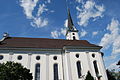
Rain Church

Interior of the church

Ceiling painting in the church

Restaurant in the village center
_258.JPG)
_247.JPG)
_253.JPG)
_260.JPG)
literature
Gabriela Mattmann : The reds and the blacks. The community of Rain and its music associations. University of Zurich, 2002, ISBN 3-908784-00-X .
Web links
- Official website of the Rain community
- Community profile of the cantonal statistical office (PDF, 110 kB)
- Waltraud Hörsch: Rain. In: Historical Lexicon of Switzerland .
Individual evidence
- ↑ Permanent and non-permanent resident population by year, canton, district, municipality, population type and gender (permanent resident population). In: bfs. admin.ch . Federal Statistical Office (FSO), August 31, 2019, accessed on December 22, 2019 .
- ↑ Permanent resident population according to nationality category, gender and municipality ( memento of the original from January 1, 2015 in the Internet Archive ) Info: The archive link was inserted automatically and has not yet been checked. Please check the original and archive link according to the instructions and then remove this notice. (Permanent resident population)
- ↑ Balance of the permanent resident population according to demographic components, institutional structure, nationality and gender (Federal Statistical Office, STAT-TAB)
- ↑ LUSTAT: Community profile Rain ( Memento of the original from May 8, 2016 in the Internet Archive ) Info: The archive link was inserted automatically and has not yet been checked. Please check the original and archive link according to the instructions and then remove this notice.
- ↑ LUSTAT: Community profile Rain ( Memento of the original from May 8, 2016 in the Internet Archive ) Info: The archive link was inserted automatically and has not yet been checked. Please check the original and archive link according to the instructions and then remove this notice.
- ↑ National Council elections 2015: strength of the parties and voter turnout by municipality. In: Results of the National Council elections 2015. Federal Statistical Office, 2016, accessed on June 1, 2016 .
Aesch | Altwis | Ballwil | Emmen | Ermensee | Eschenbach | Hitzkirch | Hochdorf | Hohenrain | Inwil | Rain | Römerswil | Rothenburg | Schongau
Former communities: Gelfingen | Hemicon | Herlisberg | Lieli | Mosen | Müswangen | Retschwil | Richensee | Sulz
Canton of Lucerne | Constituencies of the Canton of Lucerne | Municipalities of the Canton of Lucerne