
Dietwil
| Dietwil | |
|---|---|
 |
|
| State : |
|
| Canton : |
|
| District : | Muri |
| BFS no. : | 4231 |
| Postal code : | 6042 |
| Coordinates : | 672 310 / 222 416 |
| Height : | 436 m above sea level M. |
| Height range : | 400-539 m above sea level M. |
| Area : | 5.49 km² |
| Residents: | 1335 (December 31, 2019) |
| Population density : | 243 inhabitants per km² |
|
Proportion of foreigners : (residents without citizenship ) |
16.6% (December 31, 2019) |
| Website: | www.dietwil.ch |
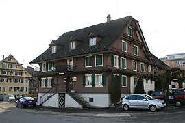
 Parish church and rectory |
|
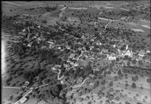
| Location of the municipality | |
  |
|
Dietwil ( Swiss German : Diettel, ˈdiətːəl ) is a municipality in the Swiss canton of Aargau . It belongs to the Muri district , lies in the Reuss valley and is the southernmost municipality in the canton. The municipality used to be called Kleindietwil or Dietwil im Reuss valley to distinguish it from Grossdietwil in Lucerne (not to be confused with Kleindietwil in Bern ).
geography
The village is about one and a half kilometers from the western bank of the Reuss on a moraine hill . This is located at the foot of the Iberg, which forms the western municipal boundary and at the same time the border to the Seetal . The plain between the village and the river is completely flat, the river itself is bordered by a flood protection dam and a drainage canal running behind it. The hamlet of Eien is located about two hundred meters from the river bank, and several individual farms are scattered on the slopes of the Iberg.
The area of the municipality is 549 hectares , 98 hectares of which are forested and 52 hectares are built over. The highest point of the municipality is at 538 m above sea level. M. , the deepest at 400 m above sea level. M. on the Reuss. Neighboring communities are Oberrüti in the north, Risch in the east, Honau in the southeast, Inwil in the south and Sins in the west.
history
In 1236 Tuerwile was mentioned for the first time in a deed of donation from Engelberg Monastery , although this is a misspelling of Tuetwile . The place name comes from the Old High German Tuotinwilari and means "Hofsiedlung des Tuoto". In the Middle Ages the village belonged to the Habsburg office of Meienberg .
In 1415 Lucerne conquered the Meienberg office, but in 1425 had to return it to the common property of the Confederates . The free offices were formed from the conquered areas , a common rule . At the beginning of the 15th century, the von Moos family from Lucerne acquired lower jurisdiction . In 1422 she sold it to the city of Lucerne, which was able to exert a great influence on the village, even though it was legally part of the common property of the Confederates. In March 1798 the French took Switzerland and proclaimed the Helvetic Republic . Dietwil was initially a municipality in the Muri district of the short-lived canton of Baden , since 1803 it has belonged to the canton of Aargau.
During the Sonderbund War of 1848, which ultimately led to the establishment of the Swiss federal state, the people of Zurich had set up their army camp in Dietwil when they advanced towards Lucerne. Their leaders tried to recruit people from the village, but the Dietwiler remained neutral and did not take sides with either side. In 1863 the canton forced the Dietwil community to naturalize gypsies who had fled Belarus during the Napoleonic wars . Two ferries operated across the Reuss until around 1900 .
Until well into the 20th century Dietwil remained a small village that lived mainly from agriculture . The population stagnated for many decades. But then the opening of the A14 motorway in the immediate vicinity and the proximity to the agglomerations of Lucerne and Zug ensured a surge in growth. The village developed into a residential community and the population increased by almost two thirds in 25 years.
Attractions
The oldest written mention of the parish church St. Jakobus Major and St. Barbara comes from the year 1145. The first new building was made in 1456; from this time the foundation walls of the church tower have been preserved. In 1780/81 the church was completely rebuilt. This created a baroque hall church , which was one of the first churches in Aargau to have classicist elements. Next to the church are the ossuary chapel (1780) and the rectory (1821); together they form a historical group of buildings enclosed by a wall.
coat of arms
The blazon of the municipal coat of arms reads: "Divided by white with a cross-shaped black shield fitting and by blue." The colors blue and white are reminiscent of the close ties between the village and the city of Lucerne. The cross-shaped shield fitting comes from the coat of arms of the Lords of Eschenbach, the donors of the Dietwil church. The coat of arms was introduced in 1936.
population
The population developed as follows:
| year | 1850 | 1900 | 1930 | 1950 | 1960 | 1970 | 1980 | 1990 | 2000 | 2010 |
| Residents | 794 | 560 | 600 | 624 | 634 | 633 | 633 | 846 | 1,023 | 1'215 |
On December 31, 2019, 1335 people lived in Dietwil, the proportion of foreigners was 16.6%. In the 2015 census, 62.9% described themselves as Roman Catholic and 11.2% as Reformed ; 25.9% were non-denominational or of other faiths. In the 2000 census, 96.7% stated German as their main language.
photos

Parish church

Rectory
Restaurant grape

school

Chaplaincy

Gumpelsfahr residential building
.jpg)
.jpg)

.jpg)

.jpg)
Politics and law
The assembly of those entitled to vote, the municipal assembly , exercises legislative power. The executing authority is the five-member municipal council . He is elected by the people in the majority procedure, his term of office is four years. The parish council leads and represents the parish. To this end, it implements the resolutions of the municipal assembly and the tasks assigned to it by the canton. The District Court of Muri is primarily responsible for legal disputes . Dietwil belongs to the Friedensrichterkreis XIII (Muri).
economy
According to the corporate structure statistics (STATENT) collected in 2015, Dietwil has around 210 jobs, of which 44% are in agriculture, 7% in industry and 49% in the service sector. There are wood and metal processing companies, a cheese dairy and two larger market gardens. The majority of the working population earns their living in the agglomerations of the cities of Lucerne and Zug .
traffic
The main road 25 from Lenzburg to Lucerne runs through the middle of the village. A bus line operated by the Busbetriebe Seetal-Freiamt company (part of the Zugerland Verkehrsbetriebe since 2004 ) also runs here between the Sins and Gisikon - Root train stations . The Root junction of the A14 motorway is just over two kilometers south .
education
The community has a kindergarten and a primary school . All upper levels of the compulsory elementary school ( Realschule , Secondary School , District School ) can be attended in Sins . The closest grammar school is the Cantonal School in Wohlen .
Personalities
- Benno Wiss (* 1962), racing cyclist
literature
- Anton Wohler: Dietwil. In: Historical Lexicon of Switzerland .
- Georg Germann : The art monuments of the canton Aargau . Ed .: Society for Swiss Art History . Volume V: The Muri District. Birkhäuser Verlag, Basel 1967, DNB 457321970 .
Web links
Individual evidence
- ↑ Cantonal population statistics 2019. Department of Finance and Resources, Statistics Aargau, March 30, 2020, accessed on April 2, 2019 .
- ↑ Cantonal population statistics 2019. Department of Finance and Resources, Statistics Aargau, March 30, 2020, accessed on April 2, 2019 .
- ↑ a b Beat Zehnder: The community names of the canton of Aargau . In: Historical Society of the Canton of Aargau (Ed.): Argovia . tape 100 . Verlag Sauerländer, Aarau 1991, ISBN 3-7941-3122-3 , p. 128-129 .
- ^ National map of Switzerland, sheets 1130 and 1131, Swisstopo.
- ↑ Standard area statistics - municipalities according to 4 main areas. Federal Statistical Office , November 26, 2018, accessed on May 10, 2019 .
- ^ Germann: The art monuments of the Canton of Aargau, Volume V: District of Muri.
- ^ Joseph Galliker, Marcel Giger: Municipal coat of arms of the Canton of Aargau . Lehrmittelverlag des Kantons Aargau, book 2004, ISBN 3-906738-07-8 , p. 140 .
- ↑ Population development in the municipalities of the Canton of Aargau since 1850. (Excel) In: Eidg. Volkszählung 2000. Statistics Aargau, 2001, archived from the original on October 8, 2018 ; accessed on May 8, 2019 .
- ↑ Resident population by religious affiliation, 2015. (Excel) In: Population and Households, Community Tables 2015. Statistics Aargau, accessed on May 10, 2019 .
- ↑ Swiss Federal Census 2000: Economic resident population by main language as well as by districts and municipalities. (Excel) Statistics Aargau, archived from the original on August 10, 2018 ; accessed on May 8, 2019 .
- ↑ circles of justice of the peace. Canton of Aargau, accessed on June 20, 2019 .
- ↑ Statistics of the corporate structure (STATENT). (Excel, 157 kB) Statistics Aargau, 2016, accessed on May 8, 2019 .
Abtwil | Aristau | Auw | Beinwil (Freiamt) | Besenbüren | Bettwil | Boswil | Coins | Buttwil | Dietwil | Geltwil | Kallern | Merenschwand | Mühlau | Muri | Oberrüti | Rottenschwil | Sins | Waltenschwil
Former municipality: Benzenschwil | Forest houses | Will
Canton of Aargau | Districts of the Canton of Aargau | Municipalities in the Canton of Aargau