
Grossdietwil
| Grossdietwil | |
|---|---|
 |
|
| State : |
|
| Canton : |
|
| Constituency : | Willisau |
| BFS no. : | 1131 |
| Postal code : | 6146 |
| Coordinates : | 633 841 / 224 650 |
| Height : | 570 m above sea level M. |
| Height range : | 547–752 m above sea level M. |
| Area : | 10.20 km² |
| Residents: | 858 (December 31, 2018) |
| Population density : | 84 inhabitants per km² |
|
Proportion of foreigners : (residents without citizenship ) |
7.7% (December 31, 2,015) |
| Website: | www.grossdietwil.ch |
 Farmhouses in the village center of Grossdietwil |
|
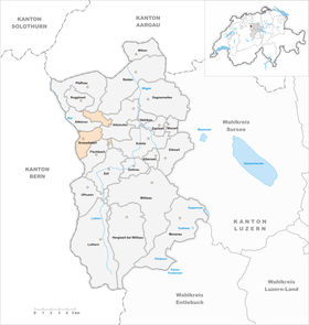
| Location of the municipality | |
  |
|
Grossdietwil is a municipality in the Willisau constituency in the canton of Lucerne in Switzerland .
geography
Grossdietwil is on the street Zell LU - St. Urban on the right bank of the (Gondiswiler-) Rotbach . This forms the western border of the municipality and is also the border between the cantons of Bern and Lucerne. In addition to the village and the surrounding area, two exclaves also belong to the community. One is the hamlet of Eppenwil (3.1 km north of the village; 668 m above sea level ) and Erpolingen (3 km northeast of the village; 700 m above sea level ). The second exclave is called Kället and is 3.1 km east of the main settlement at 631 m above sea level. M. There are also numerous groups of houses and farmsteads. The landscape is very hilly and partly forested. This is also made visible by the height differences within the community. The lowest point of the municipality is Ängelgär in the northwest on the border with Altbüron at 550 m above sea level. M. In contrast, Ruegenstall is located in the southwest of the village at 752 m above sea level. M. through the village flows Fischbach , who comes from the same neighboring town. This brook flows into the Rotbach from the right at the north-western end of the village .
Since most of the hilly area has been cleared, 72.2% of the municipal area is used for agricultural purposes. 22.0% of the community area is covered by forest. Only 5.8% of the entire municipality is settlement area.
Grossdietwil borders the municipalities of Altbüron , Altishofen , Fischbach , Pfaffnau , Reiden , Roggliswil and Schötz in the canton of Lucerne . The neighboring communities of Gondiswil and Melchnau are in the canton of Bern .
population
| Population development | |
|---|---|
| year | Residents |
| 1798 | 681 |
| 1837 | 1,324 |
| 1910 | 875 |
| 1920 | 890 |
| 1930 | 806 |
| 1960 | 891 |
| 1980 | 740 |
| 1990 | 811 |
| 2000 | 808 |
| 2004 | 822 |
From 1798 to 1837 the population doubled (1798–1837: + 94.4%). After that, it fell by around a third through migration to industrial centers by 1910 (1837–1910: −33.9%). Another wave of emigration began between 1920 and 1930 (−9.4%). Overall, the number of residents decreased by almost 40% in just under 100 years (1837–1930). This was followed by an up and down (1930–1960: +10.5%; 1960–1980: −16.9%; 1980–1990: +9.6%). 1980 was the year with the lowest population. The number of residents has stagnated since 1990.
languages
The population uses a highly Alemannic dialect as their everyday language. At the last census in 2000, 93.44% said German, 4.21% Albanian and 0.50% Portuguese were their main languages.
Religions - denominations
In the past, the entire population was a member of the Roman Catholic Church. This has changed due to immigration from other regions of Switzerland and abroad. Today the religious situation is as follows: There are 81.68% Roman Catholic, 9.65% Evangelical Reformed and 0.62% Orthodox Christians. There are also 4.21% Muslims and 1.36% non-denominational. The Muslims are Albanians from Kosovo and Macedonia (as of 2000).
Origin - nationality
At the end of 2014, 780 of the 838 inhabitants were Swiss and 58 (= 6.9%) foreigners. The population consisted of 93.1% Swiss citizens. At the end of 2014, the foreign residents came from Germany (31.0%), Serbia including Kosovo (29.3%), Italy (5.2%) and Portugal (3.4%). 29.3% came from the rest of Europe and 1.7% were of non-European origin.
history
During excavations in the 1980s, the foundations of a Roman estate came to light. In a further layer above these remains, the archaeologists discovered the crypt of a Carolingian church from the 9th century. First mention by name under the name Toutewilare in the Güterrodel of Engelberg Monastery (1184/1190). As part of the Outer Office Wolhusen, the community belonged to the Barons of Wolhusen. Due to financial difficulties, they sold the entire office to the Habsburgs around 1300 . After the Battle of Sempach in 1386, the Habsburgs only ruled on paper. The real rule was the city of Lucerne , which bought the property from the Habsburgs on Whit Monday 1405. Grossdietwil remained part of the Landvogtei Willisau until 1798. After that it belonged to the Altishofen district until 1803, since then to the then newly created Willisau Office . The community was called Dietwil until 1810. Because there were other places with the same name in Switzerland, the name was changed at that time. The exclaves of Erpolingen and Eppenwil have only been part of the municipality since 1819.
politics
Municipal council
The municipal council consists of five members and is set up as follows:
- Dietmar Frei: Mayor
- Josef Müller: Mayor
- Sibylle Wyss-Häfliger: Social Director
- Karin Grob: school administrator
- Kathrin Ledermann-Schafroth: Construction manager
Cantonal elections
In the 2015 Cantonal Council elections for the Canton of Lucerne, the share of the vote in Grossdietwil was: CVP 47.4%, SVP 28.5%, FDP 17.7%, SP 3.4%, GPS 2.0%, glp 1.0%.
National Council elections
In the 2015 Swiss parliamentary elections, the share of the vote in Grossdietwil was: CVP 41.3%, SVP 30.7%, FDP 16.1%, SP 4.3%, Greens 3.3%, glp 3.2%, BDP 0, 7%.
traffic
The municipality is reached by the Zell-Altbüron-St. Urban integrated into the public transport network. In Zell there is a train station on the Lucerne-Langenthal railway line.
Grossdietwil is on the road from Zell LU to Altbüron towards St. Urban / Langenthal. The closest motorway connection is Reiden on the A2 , 13 km away.
Attractions
photos

Grossdietwil Church

Grossdietwil Church
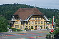
Gasthaus Löwen


Web links
- Official website of the municipality of Grossdietwil
- Community profile of the cantonal statistical office (PDF, 110 kB)
- Waltraud Hörsch: Grossdietwil. In: Historical Lexicon of Switzerland .
Individual evidence
- ↑ Permanent and non-permanent resident population by year, canton, district, municipality, population type and gender (permanent resident population). In: bfs. admin.ch . Federal Statistical Office (FSO), August 31, 2019, accessed on December 22, 2019 .
- ↑ Permanent resident population by nationality, gender and municipality ( Memento from January 1, 2015 in the Internet Archive ) (permanent resident population)
- ↑ Balance of the permanent resident population according to demographic components, institutional structure, nationality and gender (Federal Statistical Office, STAT-TAB)
- ^ Community profile Grossdietwil ( Memento from May 8, 2016 in the Internet Archive )
- ^ LUSTAT: Community profile Grossdietwil ( Memento from May 8, 2016 in the Internet Archive )
- ↑ National Council elections 2015: strength of the parties and voter turnout by municipality. In: Results of the National Council elections 2015. Federal Statistical Office, 2016, accessed on June 3, 2016 .
Alberswil | Altbüron | Altishofen | Dagmersellen | Egolzwil | Ettiswil | Fischbach | Gettnau | Grossdietwil | Hergiswil near Willisau | Luther | Menznau | Nebikon | Pfaffnau | Reiden | Roggliswil | Schötz | Ufhusen | Wauwil | Wikon | Willisau | Cell
Former parishes: Buchs | Boar corners | Kottwil | Langnau near Reiden | Ohmstal | Richenthal | Uffikon | Willisau Land | Willisau city
Canton of Lucerne | Constituencies of the Canton of Lucerne | Municipalities of the Canton of Lucerne