
Gondiswil
| Gondiswil | |
|---|---|
 |
|
| State : |
|
| Canton : |
|
| Administrative district : | Oberaargau |
| BFS no. : | 0326 |
| Postal code : | 4955 |
| Coordinates : | 632 993 / 221742 |
| Height : | 660 m above sea level M. |
| Height range : | 573–731 m above sea level M. |
| Area : | 9.40 km² |
| Residents: | 730 (December 31, 2018) |
| Population density : | 78 inhabitants per km² |
| Website: | www.gondiswil.ch |
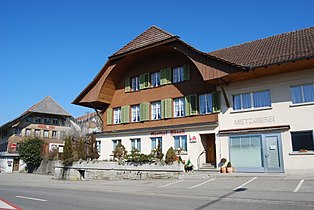
_045.JPG) Main street in the village center |
|
| Location of the municipality | |
  |
|
Gondiswil , dialect Gumiswil , is a municipality in the Oberaargau administrative district in the canton of Bern in Switzerland . In addition to the community of residents, there is also a civil community under the name .
geography
Gondiswil is located in Oberaargau in the Swiss plateau . The neighboring communities are Huttwil , Auswil , Madiswil , Reisiswil , Melchnau , Grossdietwil , Fischbach , Zell and Ufhusen .
population
| Population development | |
|---|---|
| year | Residents |
| 1764 | 694 |
| 1850 | 1422 |
| 1900 | 1008 |
| 1950 | 958 |
| 2000 | 734 |
| 2010 | 713 |
The community is badly affected by emigration caused by the crisis in the agricultural sector, the most important economic factor in the community.
education
The kindergarten and primary school are run together with Reisiswil. The kindergarten is in Reisiswil, the primary school in Gondiswil. There is a school bus for the kindergarten children.
economy
The community has a strong rural character, 66% of the businesses are farms. The Cuboro marble run system is manufactured in Gondiswil .
traffic
Gondiswil is located on the Wolhusen – Huttwil railway line and had a stop; From December 2009 this will no longer be served due to insufficient passenger frequency. A so-called citizens' bus has been running from Gondiswil to Huttwil since December 2004 . However, this does not figure in the official course book.
history

Shale coal was found during the construction of the railway line in 1894 . Limited coal mining took place from 1918 to 1919, but the seams were too small and the pit collapsed, creating a small lake. In the Second World War , coal was mined again. At the beginning of the 20th century, many farmers emigrated to the Säuliamt because of the Bern inheritance law ( Minorat ) , where they bought farms from farmers who were facing financial ruin. Some farmers from Gondiswil moved to Ottenbach .
Johann Schär (1855–1938) from Gondiswil photographed people in and around the community for decades.
photos

Village entrance

Historic granary

Reformed church, parish hall and post office in Gondiswil

Economy to the train station in bus stop
Rössli Gondiswil
_020.JPG)
_043.JPG)
_031.JPG)
_014.JPG)
_046.JPG)
Attractions
literature
- Max Jufer (Red.): The Aarwangen district and its communities . Published by the Aarwangen district and the 25 municipalities. Merkur, Langenthal 1991, ISBN 3-9070-1210-0 .
Web links
- Official website of the municipality of Gondiswil
- Anne-Marie Dubler : Gondiswil. In: Historical Lexicon of Switzerland .
Individual evidence
- ↑ Permanent resident population from STAT-TAB of the BfS , municipalities see also regional portraits 2020 on bfs.admin.ch, accessed on May 29, 2020
- ↑ Ottenbacher history (s): told by Ottenbachers in the years 2009/2010 . IG Ottenbacher Histories (ed.), Ottenbach 2013, ISBN 978-3-906068-02-2
- ^ Radio SRF: Regional Journal Bern Freiburg Wallis: Historical photographs - images of the upswing in Oberaargau. February 7, 2017. Retrieved February 8, 2017 .
Aarwangen | Attiswil | Exit | Bannwil | Berken | Bettenhausen | Bleienbach | Busswil near Melchnau | Eriswil | Farners | Gondiswil | Dig | Heimenhausen | Herzogenbuchsee | Huttwil | Inkwil | Langenthal | Lotzwil | Madiswil | Melchnau | Niederbipp | Niederönz | Oberbipp | Top stake | Ochlenberg | Oeschenbach | Reisiswil | Roggwil | Rohrbach | Rohrbachgraben | Rumisberg | Rütschelen | Black Houses | Seeberg | Foolish | Thunstetten | Ursenbach | Walliswil near Niederbipp | Walliswil near Wangen | Walterswil | Wangen an der Aare | Wangenried | Wiedlisbach | Wynau | Wyssachen
Former municipalities: Bollodingen | Gutenburg | Hermiswil | Kleindietwil | Leimiswil | Oberönz | Röthenbach near Herzogenbuchsee | Shear | Undercut wood | Wanzwil | Wolfisberg
Canton of Bern | Administrative districts of the canton of Bern | Municipalities of the Canton of Bern