
Ferns
| Ferns | |
|---|---|
 |
|
| State : |
|
| Canton : |
|
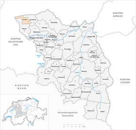
| Administrative district : | Oberaargau |
| BFS no. : | 0975 |
| Postal code : | 4539 |
| Coordinates : | 613 811 / 235249 |
| Height : | 800 m above sea level M. |
| Height range : | 654–1187 m above sea level M. |
| Area : | 3.68 km² |
| Residents: | 202 (December 31, 2018) |
| Population density : | 55 inhabitants per km² |
| Website: | www.farnern.ch |
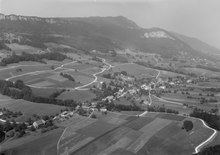
_097.JPG) Farners (back right; Attiswil in the foreground ) |
|
| Location of the municipality | |
  |
|
Farnern is a municipality in the Oberaargau administrative district in the canton of Bern in Switzerland .
geography
Farnern is at 800 m above sea level. M. , 9 km northeast of the city of Solothurn (linear distance). The village road extends in a promising location on a Verebnungsfläche on the south side of the foremost Jura chain , about 400 m above the plane of the Swiss Midland , above Wiedlisbach , in the region Oberaargau .
The area of the 3.7 km² municipal area includes a section of the southern slopes of the Jura. The slope of Farnern is subdivided by several small streams that flow into the Aare . It is the product of a huge landslide that occurred at the end of the crack ice age, when the ice age's stabilizing effect ceased to exist with the retreat of the ice age Rhone glacier . As a result, the southern limb of the anticline of the first Jura chain slipped, leaving a large landslide zone.
In the south, the border runs parallel to the slope at an altitude of around 700 to 750 m above sea level. M. above the steep forest slope in the area of Gisflüeli . From here, the municipality extends northward over the open slope of Farnern to the Schattenberg ( 1153 m above sea level ), the crest of which has a characteristic rock face ( Dogger ). In a narrow tip of the community spell reaches to the west and includes the Ausräumungskessel the Schmid Matt (in the catchment area of the Dünnern ), limited by the height of the Bättlerchuchi in the south and through the jagged limestone ( Malm ) of Rüttelhorns (with 1193 m above sea level. M. the highest Elevation of ferns) in the north and through the eastern flank of the Chamben (up to 1188 m above sea level ). In 1997, 3% of the municipal area was accounted for by settlements, 30% for forests and woodlands and 67% for agriculture.
Various individual farms belong to ferns. Neighboring communities of Farnern are Rumisberg and Attiswil in the canton of Bern and Günsberg and Herbetswil in the canton of Solothurn .
population
With 202 inhabitants (as of December 31, 2018) Farnern is one of the small communities in the canton of Bern. 98.6% of the residents are German-speaking and 0.9% French-speaking (as of 2000). The population of Farners was 268 in 1850 and 274 in 1900. In the course of the 20th century, the population decreased by over 40% to 159 people by 1970 due to strong emigration. Since then, a slight increase in population has been recorded.
economy
Until the second half of the 20th century, Farnern was a village dominated by agriculture . Even today, dairy farming , cattle breeding and some arable farming have an important place in the income structure of the population. Some other jobs are available in local small businesses and in the service sector. In the last few decades the village has developed into a residential community thanks to its attractive location. Many workers are therefore commuters who work mainly in the larger towns along the southern foot of the Jura. Farnern has a large number of second homes.
traffic
The community is located off the major thoroughfares, but is still very well developed in terms of traffic. The main access is from Wiedlisbach . The nearest connection to the A1 motorway (Bern-Zurich) is around 6 km from the town center. The village is connected to the public transport network by a bus route from Wangen an der Aare to Farnern.
history
The first written mention of the place took place in 1329 under the name Varnerron . Later the names Varnerren (1364) and Varneren (1423) appeared. The place name is derived from the Old High German word faran (fern).
Since the Middle Ages, Farnern has been under the Landgraviate of Buchsgau, administered by the Counts of Frohburg . It belonged to the Bipp rule and shared their fate. As part of this rule, Farnern came under the joint administration of Bern and Solothurn in 1413 . After the division of Buchsgau, the village came under the sole sovereignty of Bern in 1463 and was assigned to the Bipp district. Until 1511 Farnern formed a community with the neighboring Rumisberg .
After the collapse of the Ancien Régime (1798), Farnern belonged to the district of Wangen during the Helvetic Republic and from 1803 to the Oberamt Wangen, which received the status of an official district with the new cantonal constitution of 1831. Farnern does not have its own church, it belongs to the parish of Oberbipp .
See also
Web links
- Official website of the municipality of Farnern
- Anne-Marie Dubler : Farners. In: Historical Lexicon of Switzerland .
Individual evidence
- ↑ Permanent resident population from STAT-TAB of the BfS , municipalities see also regional portraits 2020 on bfs.admin.ch, accessed on May 29, 2020
Aarwangen | Attiswil | Exit | Bannwil | Berken | Bettenhausen | Bleienbach | Busswil near Melchnau | Eriswil | Farners | Gondiswil | Dig | Heimenhausen | Herzogenbuchsee | Huttwil | Inkwil | Langenthal | Lotzwil | Madiswil | Melchnau | Niederbipp | Niederönz | Oberbipp | Top stake | Ochlenberg | Oeschenbach | Reisiswil | Roggwil | Rohrbach | Rohrbachgraben | Rumisberg | Rütschelen | Black Houses | Seeberg | Foolish | Thunstetten | Ursenbach | Walliswil near Niederbipp | Walliswil near Wangen | Walterswil | Wangen an der Aare | Wangenried | Wiedlisbach | Wynau | Wyssachen
Former municipalities: Bollodingen | Gutenburg | Hermiswil | Kleindietwil | Leimiswil | Oberönz | Röthenbach near Herzogenbuchsee | Shear | Undercut wood | Wanzwil | Wolfisberg
Canton of Bern | Administrative districts of the canton of Bern | Municipalities of the Canton of Bern