
Bannwil
| Bannwil | |
|---|---|
 |
|
| State : |
|
| Canton : |
|
| Administrative district : | Oberaargau |
| BFS no. : | 0323 |
| Postal code : | 4913 |
| Coordinates : | 622 309 / 231846 |
| Height : | 434 m above sea level M. |
| Height range : | 408–493 m above sea level M. |
| Area : | 4.78 km² |
| Residents: | 669 (December 31, 2018) |
| Population density : | 140 inhabitants per km² |
| Mayor : | Karl Friedli ( independent ) |
| Website: | www.bannwil.ch |
_050.JPG) Bannwil, photographed from a balloon on April 16, 2011 |
|
| Location of the municipality | |
  |
|
Bannwil is a municipality in the Oberaargau administrative district in the canton of Bern in Switzerland . There is also a civic community under the name Bannwil . Bannwil lies on the river Aare and is surrounded by wide fields.
geography
Bannwil is located in Oberaargau in the Swiss plateau on the northern bank of the Aare . The neighboring communities starting from the north and clockwise are Niederbipp , Schwarzhäusern , Aarwangen , Graben BE , Berken , Walliswil bei Niederbipp and Oberbipp . Bannwil is the northernmost municipality in the former administrative district of Aarwangen. The protected island Vogelraupfi belongs to the municipality .

population
The number of inhabitants has been increasing again for some years now, and in July 2012 the limit of 700 inhabitants was reached again for a long time. The proportion of foreigners in Bannwil is around 6%.
economy
The economy is fairly homogeneously distributed across the three sectors of agriculture, trade and services.
traffic
Bannwil has a train station for the Aare Seeland mobil (ASm) on the former Langenthal-Jura-Bahn .
- Bannwil – Langenthal; with connection to Bern / Zurich
- Bannwil – Niederbipp – Oensingen-Solothurn; with connection to Bern / Zurich
The Niederbipp motorway junction on the A1 is about three minutes by car from Bannwil.
Attractions
Church of Bannwil
It is not known when Christianity found its way into Bannwil. Since the church was consecrated to "Maria and Archangel Michael", it is believed that it was built between the fifth and eighth centuries. The first, wooden church probably burned down once, because under the current church floor there is an approx. 20 cm thick layer of fire. It is not known when the foundation stone for today's church was laid; one can only say that the church is more than 700 years old, as the documents never mentioned a new building, only renovations. The first mention is in a papal tax bill from the years 1302-1304.
Largest boulder in the Bernese Mittelland
The boulder slipped from its original position in the boulder horizon in July 1971, whereby the residents initially believed they had felt an earthquake. In fact, the cause was a rock of unusual dimensions. The length of the ship-like colossus is 15 meters, including the bow-like porch of 2 meters, the width 5.6–7 meters, the height about 4 meters. This results in a volume of 330 m 3 . It is likely to be the largest erratics in the Bernese Mittelland.
Rhone glacier
The vastly developed Rhone glacier divides when it exits the Alps in the Lake Geneva region, the southern arm of the ice flowed further down the Rhone, the northern one into the central plateau. This also took up the Aare glacier. The glacier just reached into the area around Bannwil and deposited a whole series of moraines in the area of Solothurn - Wiedlisbach - Wangen - Oberbipp - Bannwil - Bützberg - Thunstetten - Riedtwil.
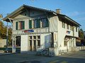
The Bannwil train station
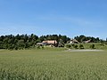
The hamlet of Kleben near Aarwangen, which belongs to Bannwil

The lower part of the village of Bannwil from the banks of the Aare


literature
- Residential community (Ed.): Bannwil , 1993
Web links
- Official website of the municipality of Bannwil
- Anne-Marie Dubler : Bannwil. In: Historical Lexicon of Switzerland .
Individual evidence
- ↑ Permanent resident population from STAT-TAB of the BfS , municipalities see also regional portraits 2020 on bfs.admin.ch, accessed on May 29, 2020
Aarwangen | Attiswil | Exit | Bannwil | Berken | Bettenhausen | Bleienbach | Busswil near Melchnau | Eriswil | Farners | Gondiswil | Dig | Heimenhausen | Herzogenbuchsee | Huttwil | Inkwil | Langenthal | Lotzwil | Madiswil | Melchnau | Niederbipp | Niederönz | Oberbipp | Top stake | Ochlenberg | Oeschenbach | Reisiswil | Roggwil | Rohrbach | Rohrbachgraben | Rumisberg | Rütschelen | Black Houses | Seeberg | Foolish | Thunstetten | Ursenbach | Walliswil near Niederbipp | Walliswil near Wangen | Walterswil | Wangen an der Aare | Wangenried | Wiedlisbach | Wynau | Wyssachen
Former municipalities: Bollodingen | Gutenburg | Hermiswil | Kleindietwil | Leimiswil | Oberönz | Röthenbach near Herzogenbuchsee | Shear | Undercut wood | Wanzwil | Wolfisberg
Canton of Bern | Administrative districts of the canton of Bern | Municipalities of the Canton of Bern