
Thunstetten BE
| BE is the abbreviation for the canton of Bern in Switzerland and is used to avoid confusion with other entries of the name Thunstetten . |
| Thunstetten | |
|---|---|
 |
|
| State : |
|
| Canton : |
|
| Administrative district : | Oberaargau |
| BFS no. : | 0342 |
| Postal code : | 4922 Thunstetten 4922 Bützberg |
| UN / LOCODE : | CH BZG (Bützberg) |
| Coordinates : | 624 119 / 228185 |
| Height : | 504 m above sea level M. |
| Height range : | 454-545 m above sea level M. |
| Area : | 9.66 km² |
| Residents: | 3397 (December 31, 2018) |
| Population density : | 352 inhabitants per km² |
| Mayor : | Beat Siegrist ( SP ) |
| Website: | www.thunstetten.ch |
_246.JPG) Thunstetten BE |
|
| Location of the municipality | |
  |
|
Thunstetten (in the local dialect : [ ˈtʊːnˌʃtɛtːə ]) is a municipality in the Oberaargau administrative district in the canton of Bern in Switzerland .
In addition to the resident community, there is an evangelical-reformed church community and a civic community under the name Thunstetten .
Although the municipality is called Thunstetten, the largest place is Bützberg , where the municipal administration is also located.
geography

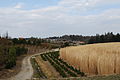
Thunstetten is located in the Oberaargau part of the canton of Bern in the Swiss plateau . The neighboring communities are Aarwangen , Langenthal , Bleienbach , Thörigen , Herzogenbuchsee and Graben . In addition to the aforementioned villages of Bützberg and Thunstetten (1220 Tunchsteten), the hamlets of Butzimatt, Erlenmoos, Forst, Im Holz, Hof, Ischmatt, Längmatt, Moos, Auf dem Rain, Rank, Rängershäusern, Sängeli, Weissenried, Welschland and Wischberg belong to the municipality of Thunstetten.
history
The Johanniterkommende Thunstetten is attested in 1220 as domus hospitalis in Tunchsteten . It was probably created before 1210 by an unknown donor and has had its own seal since 1274 . Local noble families, u. a. those of Balm , Luternau and Önz supported the coming ones with donations. The Commandery itself rounded off in the 13th / 14th Century their land and judicial rule Thunstetten. The Johanniter von Thunstetten owned goods a. a. in Oberaargau, Seeland, in Twann (vineyards) and acquired various church records , for example in Lotzwil , Ursenbach , Egerkingen , Aetigen , Rohrbach and Waldkirchen ( Niederbipp municipality ). They were closely connected with the Münchenbuchsee Commandery , u. a. different commander provided the two houses in personal union. The Commandery closed castle rights with Wangen (1320) and Bern (1329, 1466, 1494, 1504). During the Reformation the Commandery was secularized; the entire property passed to Bern and was administered by the governor of Aarwangen.
Attractions
In Thunstetten is the small Thunstetten Castle , which was built for Hieronymus von Erlach from 1713 to 1715 .
photos
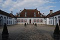
Thunstetten Castle

reformed Church

Restaurant Löwen, historic half-timbered house
Tree nursery on the outskirts
_259.JPG)
_265.JPG)
_286.JPG)
_293.JPG)
Burger families
The following families belong to the Burgers of Thunstetten: Amport, Born, Brügger, Burri, Grogg, Gygax, Hug, Iseli, Jenzer, Marti, Rickli, Sägesser, Schneider, Strasser, Trösch, Waldmann and Wüthrich.
literature
- Arnold Kümmerli: Home book of Thunstetten . 2 volumes. (Volume I: From Antiquity to the Reformation ; Volume II: After the Reformation up to the most recent times ). Oberland-Verlag, Interlaken 1952/1958.
- Max Jufer (Red.): The Aarwangen district and its communities . Published by the Aarwangen district and the 25 municipalities. Merkur, Langenthal 1991, ISBN 3-907012-10-0 .
Web links
- Official website of the municipality of Thunstetten
- Anne-Marie Dubler : Bützberg. In: Historical Lexicon of Switzerland .
- Anne-Marie Dubler: Thunstetten. In: Historical Lexicon of Switzerland .
Individual evidence
- ↑ Permanent resident population from STAT-TAB of the BfS , municipalities see also regional portraits 2020 on bfs.admin.ch, accessed on May 29, 2020
- ^ A b Andres Kristol: Thunstetten BE (Aarwangen) in: Dictionnaire toponymique des communes suisses - Lexicon of Swiss community names - Dizionario toponomastico dei comuni svizzeri (DTS | LSG). Center de dialectologie, Université de Neuchâtel, Verlag Huber, Frauenfeld / Stuttgart / Vienna 2005, ISBN 3-7193-1308-5 and Éditions Payot, Lausanne 2005, ISBN 2-601-03336-3 , p. 874.
- ↑ Burgergemeinde Thunstetten , Thunstetten website, accessed on January 16, 2012.
Aarwangen | Attiswil | Exit | Bannwil | Berken | Bettenhausen | Bleienbach | Busswil near Melchnau | Eriswil | Farners | Gondiswil | Dig | Heimenhausen | Herzogenbuchsee | Huttwil | Inkwil | Langenthal | Lotzwil | Madiswil | Melchnau | Niederbipp | Niederönz | Oberbipp | Top stake | Ochlenberg | Oeschenbach | Reisiswil | Roggwil | Rohrbach | Rohrbachgraben | Rumisberg | Rütschelen | Black Houses | Seeberg | Foolish | Thunstetten | Ursenbach | Walliswil near Niederbipp | Walliswil near Wangen | Walterswil | Wangen an der Aare | Wangenried | Wiedlisbach | Wynau | Wyssachen
Former municipalities: Bollodingen | Gutenburg | Hermiswil | Kleindietwil | Leimiswil | Oberönz | Röthenbach near Herzogenbuchsee | Shear | Undercut wood | Wanzwil | Wolfisberg
Canton of Bern | Administrative districts of the canton of Bern | Municipalities of the Canton of Bern