
Rumisberg
| Rumisberg | |
|---|---|
 |
|
| State : |
|
| Canton : |
|
| Administrative district : | Oberaargau |
| BFS no. : | 0987 |
| Postal code : | 4539 |
| Coordinates : | 615 346 / 234 857 |
| Height : | 638 m above sea level M. |
| Height range : | 549–1228 m above sea level M. |
| Area : | 5.14 km² |
| Residents: | 488 (December 31, 2018) |
| Population density : | 95 inhabitants per km² |
| Website: | www.rumisberg.ch |
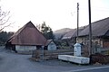
 Center Rumisberg |
|
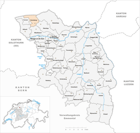
| Location of the municipality | |
  |
|
Rumisberg is a municipality in the Oberaargau administrative district in the canton of Bern in Switzerland .
geography
Rumisberg lies at 638 m above sea level. M. , 11 km northeast of the city of Solothurn (linear distance). The Haufendorf extends in a promising location on a Verebnungsfläche on the south side of the foremost Jura chain (Leberberg), 200 m above the plane of the Swiss Midland , above Wiedlisbach , in the region Oberaargau .
The area of the 5.2 km² municipal area covers a section of the southern slopes of the Jura. The slope of Rumisberg is subdivided by several small brooks that flow into the Aare . It is the product of a huge landslide that occurred at the end of the crack ice age, when the ice age's stabilizing effect ceased to exist with the retreat of the ice age Rhone glacier . Therefore, the southern limb of the anticline of the first Jura chain slipped and left a large landslide zone, also recognizable as a foothill zone in the area of the village.
From the Mulde near Gunzeney and the Bodenacker , the municipal soil extends northward over the terrace of Rumisberg and up the open, initially relatively gently sloping southern Jura slope. Above around 850 to 900 m above sea level. M. the slope is covered by forest and is dominated by the flutes of the Schattenberg ( 1153 m above sea level ) and the Ankehubels ( 1085 m above sea level ). The highest point of Rumisberg is on the Höllchöpfli at 1231 m above sea level. M. achieved. The Lebernberg chain has two ridges in this area, both of which belong to the northern limb of the anticline: the southern one with the Schattenberg and the Ankehubel is made of limestone from the Dogger , the northern one with the Höllchöpfli and the Rüttelhorn ( 1193 m above sea level) . ) consists of Malmkalk . The northern municipal boundary runs on this ridge. The softer clay and marl layers lying between the two hard rock layers were cleared out more by the erosion , so that a valley was created, which is drained to the north to the thin by the Horngraben gorge . In 1997, 8% of the municipal area was settled, 42% forest and woodland, 49% agriculture and a little less than 1% was unproductive land.
Rumisberg includes the settlements of Schoren ( 778 m above sea level ) and Weissacker ( 720 m above sea level ) on the slope above the village as well as some individual farms. Neighboring communities of Rumisberg are Niederbipp , Oberbipp , Wiedlisbach , Attiswil and Farnern in the canton of Bern and Aedermannsdorf and Matzendorf in the canton of Solothurn .
population
With 488 inhabitants (as of December 31, 2018) Rumisberg is one of the small communities in the canton of Bern. 98.5% of the residents speak German, 0.4% speak Italian and 0.4% speak Serbo-Croatian (as of 2000). The population of Rumisberg was 471 in 1850, and in 1900 it was 353. In the course of the 20th century, the population has always fluctuated between 320 and 390 people. Since 1980 (378 inhabitants) there has been a significant increase in population.
economy
Up until the second half of the 20th century, Rumisberg was predominantly an agricultural village. Even today, arable and fruit growing in the lower elevations as well as cattle and dairy farming in the upper part of the municipality have an important place in the income structure of the population. Further jobs are available in local small businesses and in the service sector. A paving shop, a transport company, a locksmith's shop and a carpenter's shop are represented in Rumisberg today. In the last few decades the village has developed into a residential community thanks to its attractive location. Many employed people are therefore commuters who mainly work in the larger towns along the foot of the Jura between Solothurn and Olten .
traffic
The community is located off the major thoroughfares, but is still very well developed in terms of traffic. The main access is from Wiedlisbach . The next connection to the Autobahn 1 (Bern-Zurich) is around 4 km from the town center. Rumisberg is connected to the public transport network by a bus route from Wangen an der Aare to Farnern.
history
The place was first mentioned in a document in 1364 under the name Rumolsberg . Later, the names Rumisperg (1464), Rümysperg (1518) and Rumisberg (1577) appeared. The place name goes back to the Old High German personal name Rumold and therefore means mountain / mountain pasture of Rumold .
Since the Middle Ages Rumisberg has been under the Landgraviate of Buchsgau administered by the Counts of Frohburg . It belonged to the Bipp rule and shared their fate. As part of this rule, Rumisberg came under the joint administration of Bern and Solothurn in 1413. After the division of the Buchsgau, the village came under the sole rule of Bern in 1463 and was assigned to the Bipp bailiff. Until 1511 Rumisberg formed a community with the neighboring Farnern.
After the collapse of the Ancien Régime (1798) Rumisberg belonged to the district of Wangen during the Helvetic Republic and from 1803 to the Oberamt Wangen, which received the status of an official district with the new cantonal constitution of 1831.
Attractions
In the old town center there are a number of characteristic farmhouses, mostly from the 18th century. The Hans Roth fountain stands in the village square as a souvenir of Hans Roth , who came from Rumisberg and who warned the Solothurn residents of a planned attack by Count Rudolf von Kyburg on November 10, 1382 . Rumisberg does not have its own church, it belongs to the parish of Oberbipp .
photos

Center Rumisberg
Center Rumisberg


Web links
- Official website of the Rumisberg community
- Anne-Marie Dubler : Rumisberg. In: Historical Lexicon of Switzerland .
Individual evidence
- ↑ Permanent resident population from STAT-TAB of the BfS , municipalities see also regional portraits 2020 on bfs.admin.ch, accessed on May 29, 2020
Aarwangen | Attiswil | Exit | Bannwil | Berken | Bettenhausen | Bleienbach | Busswil near Melchnau | Eriswil | Farners | Gondiswil | Dig | Heimenhausen | Herzogenbuchsee | Huttwil | Inkwil | Langenthal | Lotzwil | Madiswil | Melchnau | Niederbipp | Niederönz | Oberbipp | Top stake | Ochlenberg | Oeschenbach | Reisiswil | Roggwil | Rohrbach | Rohrbachgraben | Rumisberg | Rütschelen | Black Houses | Seeberg | Foolish | Thunstetten | Ursenbach | Walliswil near Niederbipp | Walliswil near Wangen | Walterswil | Wangen an der Aare | Wangenried | Wiedlisbach | Wynau | Wyssachen
Former municipalities: Bollodingen | Gutenburg | Hermiswil | Kleindietwil | Leimiswil | Oberönz | Röthenbach near Herzogenbuchsee | Shear | Undercut wood | Wanzwil | Wolfisberg
Canton of Bern | Administrative districts of the canton of Bern | Municipalities of the Canton of Bern