
Matzendorf SO
| SO is the abbreviation for the canton of Solothurn in Switzerland and is used to avoid confusion with other entries of the name Matzendorf . |
| Matzendorf | |
|---|---|
 |
|
| State : |
|
| Canton : |
|
| District : | Thal |
| BFS no. : | 2427 |
| Postal code : | 4713 |
| Coordinates : | 614515 / 239 581 |
| Height : | 510 m above sea level M. |
| Height range : | 488–1232 m above sea level M. |
| Area : | 11.27 km² |
| Residents: | 1332 (December 31, 2018) |
| Population density : | 118 inhabitants per km² |
| Website: | www.matzendorf.ch |
 View over Matzendorf to the north |
|
| Location of the municipality | |
  |
|
Matzendorf is a municipality in the Thal district in the canton of Solothurn in Switzerland .
geography

Matzendorf is at 510 m above sea level. M. , 5 km west of the district capital Balsthal (air line). The street row village stretches on both sides of the Dorfbach on the sunny side of the northern edge of the Balsthalertal, at the foot of the Brunnersberg range in the Solothurn Jura .
The area of the 11.3 km² municipal area comprises a section in the central part of the Balsthaler or Dünner valley, a longitudinal valley in the Solothurn Jura. The central part of the area is formed by the approximately 500 to 1000 m wide flat valley plain of the Dünnern . To the south, the municipal ban extends to the anticline of the Weissenstein chain and includes the densely wooded steep slope of the Leberen , which is limited to the west by the erosion valley of the Horngraben cut into the hard Malm limestone . The southern border runs on the forest ridge of the Höllchöpfli , which is 1231 m above sea level. M. forms the highest elevation of Matzendorf.
The Matzendorf hollow, through which the Dorfbach stream flows and is flanked by the Alphübel ( 594 m above sea level ) and Emet ( 597 m above sea level ) foothills, connects to the north of the Dünnern valley . Further to the north, the communal soil extends over the so-called Sunnenberg , the so-called Sunnenberg , which is initially relatively gentle, steeply rising in the upper part, partially with rocks and subdivided by the Wängital , up to the anticline of the Brunnersberg range with the height of the Grosse Brunnersberg (up to 1127 m above sea level ). In 1997, 7% of the municipal area was accounted for by settlements, 52% for forests and woodlands and 41% for agriculture.
Matzendorf includes the district of Müli ( 500 m above sea level ) on the southern side of the Dünnern valley as well as numerous individual farms in the valley and on the sunny slope above the village and Sennhöfe on the Jura heights. Neighboring communities of Matzendorf are Aedermannsdorf , Mümliswil-Ramiswil and Laupersdorf in the canton of Solothurn and Niederbipp and Rumisberg in the canton of Bern .
population
With 1,332 inhabitants (as of December 31, 2018) to the medium-sized municipalities of the canton of Solothurn. 96.2% of the residents speak German, 1.0% speak Albanian and 0.9% speak Serbo-Croatian (as of 2000).
economy
Matzendorf used to be a predominantly agricultural village, but iron processing and the manufacture of artificial ceramics (faience) also played an important role in the 18th and 19th centuries. In the course of the 16th century, the heights of the Brunnersberg range were cleared, extensive summer pastures were created for the cattle and several dairy farms were built. Even today, arable farming and fruit growing in the lower elevations as well as dairy farming and cattle breeding in the upper parts of the municipality have an important place in the income structure of the population.
Numerous other jobs are available in local small businesses and in the service sector. Today Matzendorf has a metal foundry, an aluminum foundry, wood construction and wood processing companies, mechanical engineering, metal construction, the building trade, mechanical workshops and a gardening shop. The village shop was recently rescued by an entrepreneur who used to live there. In the last few decades the village has also developed into a residential community. Many employed people are therefore commuters who mainly work in Balsthal and in the Olten-Solothurn area.
traffic
The community is very well developed in terms of transport. It is located on the main road from Oensingen to Moutier . Matzendorf is connected to the public transport network through a post bus course that covers the route from Balsthal to Gänsbrunnen .
history
The place was first mentioned in a document in 968 under the name Mazendorf ; from 1227 the name Macindorf has been handed down. The place name is derived from the Alemannic personal name Matzo . At the time it was first mentioned, Matzendorf was owned by the Moutier-Grandval Monastery . In the course of the 11th century the village with its Dinghof came to the Sankt-Ursen-Stift in Solothurn, from then on it formed an enclave in the area of the Counts of Frohburg and therefore experienced a different fate than the other communities in the valley.
In the 14th century the monastery sold the Dinghof Matzendorf to the Counts of Nidau . Thereafter there were various changes of ownership until the village came to A. Bumann von Olten in 1400 and enjoyed relatively great freedom. In 1449 Matzendorf was bought by Solothurn and incorporated into the Falkenstein Landvogtei, with the village becoming the seat of a court district. Various iron smelters have existed in the area of the village since the 16th century.
After the collapse of the Ancien Régime (1798) Matzendorf was assigned to the Balsthal-Thal district. In the same year, a ceramic factory was founded on the border with Aedermannsdorf, which produced Matzendorfer ceramics . From 1810 the iron smelter belonged to the Von Roll company, but was shut down in 1841 and relocated to Klus and Herbetswil. The Aedermannsdorfer Keramikfabrik emerged from the ceramic factory and was taken over by Rössler AG from Ersigen in the 20th century .
In the 19th century, especially from 1850 to around 1870, the valley was affected by severe poverty and famine, so that many residents had to emigrate.
Attractions

The Catholic Saint Pankratius Church, standing in the open on a hill west of the village, was rebuilt in 1520 in the late Gothic style and enlarged in 1781. The All Saints Chapel was built in 1949. The St. Antonius Chapel stands in the Horngraben on the site of a hermitage founded in 1450.
photos

Village chapel

Village fountain
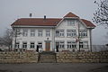
school

Gasthaus stars


coat of arms
- Split by white and blue, covered with two diagonally crossed angles in alternating colors
Web links
- Official website of the community of Matzendorf
- Albert Vogt: Matzendorf. In: Historical Lexicon of Switzerland .
- Aerial views of the village
Individual evidence
- ↑ Permanent and non-permanent resident population by year, canton, district, municipality, population type and gender (permanent resident population). In: bfs. admin.ch . Federal Statistical Office (FSO), August 31, 2019, accessed on December 22, 2019 .
- ↑ Solothurner Zeitung, March 2014
- ^ Albert Vogt: Matzendorf. In: Historisches Lexikon der Schweiz ., Accessed on February 12, 2010