
Herbetswil
| Herbetswil | |
|---|---|
 |
|
| State : |
|
| Canton : |
|
| District : | Thal |
| BFS no. : | 2424 |
| Postal code : | 4715 |
| Coordinates : | 611 681 / 238 493 |
| Height : | 524 m above sea level M. |
| Height range : | 515–1251 m above sea level M. |
| Area : | 16.30 km² |
| Residents: | 539 (December 31, 2018) |
| Population density : | 33 inhabitants per km² |
| Website: | www.herbetswil.ch |
 Herbetswil |
|
| Location of the municipality | |
  |
|
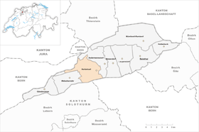
Herbetswil is a municipality in the Thal district in the canton of Solothurn in Switzerland .
geography
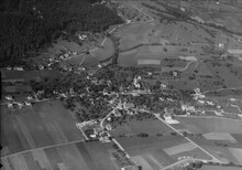
Herbetswil lies at 524 m above sea level. M. , 8 km west-southwest of the district capital Balsthal ( linear distance ). The clustered village extends on the sunny side on the northern edge of the Balsthalertal, on both sides of the Rickenbächli , at the foot of the Brunnersberg range in the Solothurn Jura .
The area of the 16.4 km² municipal area comprises a section in the western part of the Balsthaler or Dünner valley, a longitudinal valley in the Solothurn Jura. The central part of the area is formed by the approximately 500 to 700 m wide flat valley plain of the Dünnern . To the south of the municipality spell extends to the anticline of Weissenstein chain and encompasses the so-called Schattenberg , the densely wooded steep northern slope of Chamben (with 1251 m above sea level. M. the highest elevation of Herbetswil) with the Erosionstälchen Riedgraben that in the hard limestone incised is.

To the north of the Dünner valley level, the community floor extends over the steep slope of the so-called Sunnenberg to the anticline of the Brunnersberg range with the heights of Vorder Brandberg ( 1085 m above sea level ), Hornegg ( 1225 m above sea level ) and Tannmatt ( 1173 m above sea level ). The Wolfsschlucht west of the Hornegg with its catchment area also belongs to Herbetswil. A narrow tip extends over the heights of the Hinter Brandberg ( 1186 m above sea level ) to the Harzergraben . A small portion of the municipal ban north of Mieschegg and Tannmatt is in the catchment area of the Gabiare (tributary of the Scheltenbach ). In 1997, 3% of the municipal area was accounted for by settlements, 63% for forests and woodlands and 34% for agriculture.
Herbetswil includes the hamlets of Vorder Hammer ( 537 m above sea level ) in the Dünnern valley and Hinter Hammer ( 573 m above sea level ) at the western end of the valley level as well as numerous individual farms that are widely scattered on the heights of the Brunnersberg range. Neighboring communities of Herbetswil are Aedermannsdorf , Günsberg , Balm bei Günsberg , Welschenrohr and Gänsbrunnen in the canton of Solothurn and Seehof and Farnern in the canton of Bern .
population
With 539 inhabitants (as of December 31, 2018), Herbetswil is one of the smaller communities in the canton of Solothurn. 96.1% of the residents speak German, 0.9% speak Albanian and 0.9% speak Arabic (as of 2000). The population of Herbetswil was 475 in 1850 and 437 in 1900. In the course of the 20th century, the population rose to 658 people by 1950. After that, a slight decrease in population was recorded overall.
economy
Until the second half of the 20th century, Herbetswil was a village dominated by agriculture . In the course of the 16th century, the heights of the Brunnersberg range were cleared, extensive summer pastures were created for the cattle and several dairy farms were built. The Vordere Brandberg is the largest cattle grazing pasture in the canton with around 1 km². Even today, arable farming in the lower elevations, as well as dairy farming and cattle breeding in the upper parts of the municipality, play an important role in the income structure of the population. Further jobs are available in local small businesses and in the service sector. In Herbetswil there are wood processing companies and the watch company Festina-Candino Watch Ltd. (most important employer in the village). In the last few decades the village has also developed into a residential community. Many employed people are therefore commuters who mainly work in Balsthal and in the Olten-Solothurn area.
traffic
The community is very well developed in terms of transport. It is located a few 100 meters from the main road from Oensingen to Moutier . Herbetswil is connected to the public transport network through a postbus course , which covers the route from Balsthal to Gänsbrunnen every hour to 20 minutes.
history
The place was first mentioned in a document in 1400 under the name Herbrechtswil . Later the names Herbrechtswilr (1423), Ebertzwil (1444) and Herbertzwil (1467) appeared. The place name is derived from the Old High German personal name Heribrecht and means at the Heribrecht homestead .
At the time it was first mentioned, Herbetswil belonged to the Neu-Falkenstein estate. In 1420 the place came under the rule of Solothurn through purchase and was assigned to the Landvogtei Falkenstein. Since the 15th century there have been various commercial iron and coppersmiths in the area of the village, which the names Vorder and Hinter Hammer still bear witness to today. What is remarkable in this context is the fact that Herbetswil provided the first written evidence of the entire Solothurn Jura for the existence of the spruce (red fir). The tree, which is very widespread here today, needs above-average light and only seems to have advanced eastwards from the western Jura since the 18th century. This must have been in connection with heavy clearing for the aforementioned blacksmith workshops, which created clearings that favored the spruce.
After the collapse of the Ancien Régime (1798), Herbetswil was assigned to the Balsthal-Thal district. In the 19th century, especially from 1850 to around 1870, the valley was affected by severe poverty and famine, so that many residents had to emigrate. The watch industry gained a foothold at the beginning of the 20th century and is still alive today despite several crises.
Attractions
Herbetswil had had a chapel since 1549, which was demolished in 1896. The village was separated from the parish of Matzendorf in 1843 and raised to a separate parish. The new parish church was built in 1891 and has a late Gothic statue of St. John the Baptist.
photos

Herbetswil

The Vorderer Hammer settlement
school

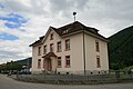
Hauptstrasse 30 near Herbetswil
_114.JPG)


coat of arms
- A black square measure plunged upright in red directed to the right
literature
- Gottlieb Loertscher: The art monuments of the canton of Solothurn, Volume III: The districts of Thal, Thierstein, Dorneck. (= Art Monuments of Switzerland. Volume 38). Edited by the Society for Swiss Art History GSK. Bern 1957, DNB 750089342 .
Web links
- Official website of the Herbetswil community
- Albert Vogt: Herbetswil. In: Historical Lexicon of Switzerland .
- Aerial views of the village
Individual evidence
- ↑ Permanent and non-permanent resident population by year, canton, district, municipality, population type and gender (permanent resident population). In: bfs. admin.ch . Federal Statistical Office (FSO), August 31, 2019, accessed on December 22, 2019 .
- ^ H. Kaufmann: Biohistorische Fragments from the Canton of Solothurn ; in: Yearbook for Solothurn History, 1976