Balm near Günsberg
| Balm near Günsberg | |
|---|---|
| State : |
|
| Canton : |
|
| District : | Livers |
| BFS no. : | 2541 |
| Postal code : | 4525 |
| Coordinates : | 609 042 / 233548 |
| Height : | 655 m above sea level M. |
| Height range : | 575-1394 m above sea level M. |
| Area : | 5.47 km² |
| Residents: | 205 (December 31, 2018) |
| Population density : | 37 inhabitants per km² |
| Website: | www.balm-balmberg.ch |
|
Balm near Günsberg |
|
| Location of the municipality | |
Balm bei Günsberg (in the local dialect Baum bi Günschbrg ) is a municipality in the Lebern district of the canton of Solothurn in Switzerland .
geography
Balm near Günsberg is 655 m above sea level. M. , 5 km north-northeast of the canton capital Solothurn (linear distance). The farm village extends in a promising location on a facing south-east at the lower terrace area Jura southern slope of about 200 meters over the level of the Swiss Midland , in the region under Leberberg.
The 5.5 km² municipal area covers a section of the Solothurn Jura . The area extends from the slope near Balm to the northwest over the rocky crests of Balmfluh (on the Balmfluhköpfli 1289 m above sea level ) and Nesselbodenröti down to the ridge of the first Jura chain (Weissenstein chain). The lowest point of this anticline is on the saddle of the Balmberg ( 1078 m above sea level ). To the west the ridge rises rapidly to the Röti , at 1395 m above sea level. M. the highest elevation of Balm near Günsberg, to the east to Wannenfluh ( 1201 m above sea level ), Niederwiler Stierenberg and Chamben ( 1227 m above sea level ). The Siggern , a tributary of the Aare , rises on the southern slope of the Balmberg with several source streams, which together have eroded away a significant part of the rock layers of the anticlines and created a clearing basin .
A small part of the municipality is located north of the ridge of the Balmberg and includes two right side streams of the Dünnern with the Schofbach and another body of water that rises from Niederwiler Stierenberg . These streams have also created deep erosion valleys in the hard Malm limestone layers of the northern limb of the first Jurassic anticlines. In 1997, 3% of the municipal area was in settlements, 65% in forests and woodlands, 30% in agriculture and a little less than 2% was unproductive land.
Balm near Günsberg includes the new housing estate Balmweid ( 730 m above sea level ) on the southern slope of the Balmfluh, above the village, the scattered settlement Balmberg ( 1050 m above sea level ) on the southern slope of the pass of the same name as well as some individual farms. Neighboring communities of Balm bei Günsberg are Günsberg , Riedholz , Rüttenen , Welschenrohr and Herbetswil .
population
With 205 inhabitants (as of December 31, 2018), Balm bei Günsberg is one of the small communities in the canton of Solothurn. 95.9% of the residents speak German, 3.1% speak English and 0.5% speak French (as of 2000). The population of Balm near Günsberg was 110 inhabitants in 1850 and 102 inhabitants in 1900. During the 20th century, the population fluctuated between 80 and 115 inhabitants. Since 1970 (80 inhabitants) there has been a significant increase in population with a doubling of the number of inhabitants within 20 years.
economy
Until the second half of the 20th century, Balm near Günsberg was a village dominated by agriculture . Even today, arable farming and fruit growing in the lower elevations as well as cattle breeding in the upper part of the municipality have an important role in the income structure of the population. Further jobs are available in local small businesses and in the service sector. In the last few decades the village has developed into a residential community thanks to its attractive location. Many employed people are therefore commuters who mainly work in the Solothurn region.
leisure

The area around Balmberg (with the Kurhaus and several restaurants) and Röti is a popular excursion and hiking area. In winter you can go skiing here; When the snow conditions are good, several ski lifts are in operation on the eastern slope of the Röti.
traffic
The community is located off the major thoroughfares on a connecting road from Günsberg to Langendorf . The village is connected to the public transport network through a post bus course , which covers the route from Solothurn to Balm near Günsberg.
history
The municipal area of Balm near Günsberg was inhabited very early, which could be proven by traces of settlement from the Neolithic near the Grottenburg Balm.
The Grottenburg Balm, the ancestral castle of the barons and knights of Balm , who are mentioned in a document in the 12th century and later also had rich possessions in Oberaargau , probably existed since the early 11th century , which is why the Balm castle was probably left to a clan of servants. The farming village of Balm developed below the castle. The first written mention of the place took place in 1197 under the name de Balma ; from 1201 the name de Balme has been handed down. Since the last lord of Balm, Rudolf II, was involved in the fatal assassination attempt against King Albrecht I of Habsburg near Windisch , the Balm reign was confiscated in 1308 after Rudolf's flight and given to the Counts of Strassberg as an imperial fief. It cannot be ruled out that the regicide in question, which was of European significance, was one of the reasons why Albrecht's third son, Duke Leopold I , administrator of the Austrian foothills , besieged the city of Solothurn in 1318 - albeit unsuccessfully.
In 1327 Balm came under the rule of the Counts of Neuchâtel-Nidau . After further changes of ownership at the end of the 14th century, the village and the rule came in 1411 to the city of Solothurn, which had had high jurisdiction over the area since 1344. The former rule of Balm has now been converted into a bailiwick, which encompassed the southern slopes of the Jura from Bellach to Flumenthal . The castle was no longer used and quickly fell into ruins. Around 1490 the Bailiwick of Balm was renamed Vogtei Flumenthal, to which Balm near Günsberg belonged until 1798.
After the collapse of the Ancien Régime (1798), Balm near Günsberg belonged to the Solothurn administrative district during the Helvetic Republic and to the Lebern district from 1803. With the separation of Niederwil from the municipality of Balm, an important change in area was made in 1822.
Attractions
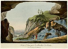
The Balm cave castle, built in the 11th century, is strategically well-protected. This medieval defense system was built in a cave in the approximately 60 m high rock face at the foot of the Balmfluh and is located around 20 m above the foot of the rock face. At the foot of the rock face remains of the former outer bailey and the farm buildings are visible. A rock staircase leads from the outer bailey to the inner bailey, which has not been inhabited since the 15th century. Remains of the walls, gate, Zwinger and residential wing were restored by the Historical Association of the Canton of Solothurn in the 1960s.
coat of arms
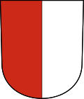
- Split by red and white
Web links
- Official website of the municipality of Balm near Günsberg
- Urs Zurschmiede: Balm near Günsberg. In: Historical Lexicon of Switzerland .
- Balm near Günsberg on the ETHorama platform
Individual evidence
- ↑ Permanent and non-permanent resident population by year, canton, district, municipality, population type and gender (permanent resident population). In: bfs. admin.ch . Federal Statistical Office (FSO), August 31, 2019, accessed on December 22, 2019 .


