
Lommiswil
| Lommiswil | |
|---|---|
 |
|
| State : |
|
| Canton : |
|
| District : | Livers |
| BFS no. : | 2551 |
| Postal code : | 4514 |
| Coordinates : | 602 461 / 230113 |
| Height : | 564 m above sea level M. |
| Height range : | 486–1362 m above sea level M. |
| Area : | 5.76 km² |
| Residents: | 1536 (December 31, 2018) |
| Population density : | 267 inhabitants per km² |
| Website: | www.lommiswil.ch |
 View of Lommiswil from the southwest |
|
| Location of the municipality | |
  |
|
Lommiswil (in the local dialect Lommiswiu ) is a municipality in the Lebern district in the canton of Solothurn in Switzerland .
geography
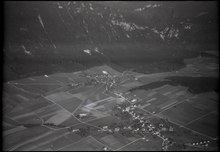
Lommiswil lies at 565 m above sea level. M. , 5 km west-northwest of the canton capital Solothurn (linear distance). The clustered village extends from a panoramic location on a wide, slightly south-sloping terrain terrace at the southern foot of the Jura , at the foot of the Hasenmatt , around 130 m above the Aare plain .
The area of the 5.8 km² municipal area includes a section of the southern slopes of the Jura. The wide terrace of Lommiswil, which slopes gently towards the Aare valley, occupies the southern part of the municipality. It is bounded in the west by the Lochbach valley and in the east by the Busletenwald . To the north, the area turns into a densely wooded steep slope, the so-called Vorberg on the southern slope of the Hasenmatt. The northern border runs on the ridge of the Weissenstein chain with the Gitziflue ( 1327 m above sea level ); on the slope below the Hasenmattwiese is 1360 m above sea level. M. reached the highest point of Lommiswil. In 1997, 12% of the municipal area was accounted for by settlements, 43% by forests and woodlands and 45% by agriculture.
Lommiswil includes the Im Holz settlement ( 607 m above sea level ) above the village at the beginning of the steep slope and a few individual farms. Lommiswil and Im Holz have grown together seamlessly thanks to the strong residential construction activity in recent years. Lommiswil's neighboring communities are Selzach , Oberdorf and Bellach .
population
With 1536 inhabitants (as of December 31, 2018) Lommiswil is one of the medium-sized communities in the canton of Solothurn. 95.6% of the residents are German-speaking, 0.9% French-speaking and 0.9% speak Italian (as of 2000). The population of Lommiswil was 417 in 1850 and 656 in 1900. During the 20th century, the population fluctuated between 740 and 820 people until 1960. Since then a significant increase in population has been recorded.
economy
Until the second half of the 20th century, Lommiswil was a village dominated by agriculture . Even today, arable farming and fruit growing as well as cattle breeding have an important place in the income structure of the population. Further jobs are available in local small businesses and in the service sector. In the community today there are companies in the construction and transport industry, IT and precision engineering workshops. In the last few decades the village has developed into a residential community thanks to its attractive location. Many employed people are therefore commuters who mainly work in the Solothurn and Grenchen regions.
traffic

The community is located off the major thoroughfares, but is easily accessible from Solothurn and Grenchen . The closest connection to the A5 motorway (Solothurn-Biel) is around 7 km from the town center. On August 1, 1908, the railway line of the Solothurn-Münster-Bahn from Solothurn to Moutier with a train station in Lommiswil and a stop at Im Holz went into operation. Since the end of 2007, Lommiswil has been connected to Grenchen by a bus operated by the Grenchen and surrounding area . Since 2012 the last bus with the number 2 of the bus company Solothurn and the surrounding area has been going to Lommiswil every day. Several buses have been going to Lommiswil every day since 2016, and to Im Holz since 2017.
history
The first written mention of the place took place in 1292 under the names Luomolswile and Lomolzwile . Later the names Lomelswile (1296), Lomolswile (1318), Lomoswile (1327) and Lomiswile (1429) appeared. The place name goes back to the Old High German personal name Lobawalt . The name ending -wil indicates a foundation by the Alemanni in the 8th or 9th century. The meaning of the place name is therefore in the courts of Lobawalt .
Lommiswil was initially under the rule of Schauenburg, later the western part belonged to the rule of Altreu and shared their fate. In 1375 the village and the Germanus chapel were destroyed by the Guglers . Together with the Altreu rulership, Lommiswil came to the city of Solothurn in 1389 and was incorporated into the Lebern Bailiwick in 1393, with the place of jurisdiction being Selzach. After the collapse of the Ancien Régime (1798), the village belonged to the Solothurn administrative district during the Helvetic and from 1803 to the Lebern district.
Attractions

Lommiswil has two churches, but has only been an independent parish since 1951; before it belonged to the parish of Oberdorf. The old church of Sankt German, the original structure of which was built in the early Middle Ages but was destroyed by the Guglers, was rebuilt in 1481 and later restored or changed several times. In 1967 the new Heilig-Geist-Kirche was consecrated, a shell concrete building by the architect Roland Hanselmann and the civil engineer Heinz Isler . The consecration took place in May 1968, the bell tower was completed later.
In the border area between Lommiswil and Oberdorf there is a quarry on the southern slope of the Jura with a viewing platform, from which there is an interesting view of numerous dinosaur footprints, the Lommiswil dinosaur slab . The tracks were left by brachiosaurs around 145 million years ago in the sand along a tropical shallow sea that covered large parts of Central Europe at the time. The quarry can be reached on foot in around 20 minutes from the BLS stop in Im Holz or Oberdorf .
coat of arms
- In blue on a green plan, a white lamb walking to the right, in the raised right front knee a gold-studded red flag with a continuous white cross
Web links
- Official website of the municipality of Lommiswil
- Urs Zurschmiede: Lommiswil. In: Historical Lexicon of Switzerland .
Individual evidence
- ↑ Permanent and non-permanent resident population by year, canton, district, municipality, population type and gender (permanent resident population). In: bfs. admin.ch . Federal Statistical Office (FSO), August 31, 2019, accessed on December 22, 2019 .
- ↑ a b Christian Sutter: Blasphemy or Art? The Holy Spirit Church is 50 years old. In: Solothurner Zeitung. March 5, 2018, accessed March 5, 2019 .
Balm near Günsberg |
Bellach |
Bettlach |
Feldbrunnen-St. Niklaus |
Flumenthal |
Grenchen |
Günsberg |
Hubersdorf |
Chamber tube |
Langendorf |
Lommiswil |
Oberdorf |
Riedholz |
Rüttenen |
Selzach
Former municipality:
Niederwil
Canton of Solothurn | Districts of the Canton of Solothurn | Municipalities of the Canton of Solothurn