
Oberdorf SO
| SO is the abbreviation for the canton of Solothurn in Switzerland and is used to avoid confusion with other entries in the name Oberdorf . |
| Oberdorf | |
|---|---|
 |
|
| State : |
|
| Canton : |
|
| District : | Livers |
| BFS no. : | 2553 |
| Postal code : | 4515 |
| Coordinates : | 604 964 / 231 227 |
| Height : | 559 m above sea level M. |
| Height range : | 494–1326 m above sea level M. |
| Area : | 11.91 km² |
| Residents: | 1724 (December 31, 2018) |
| Population density : | 145 inhabitants per km² |
| Website: | www.oberdorf.ch |
 Center of Oberdorf with church |
|
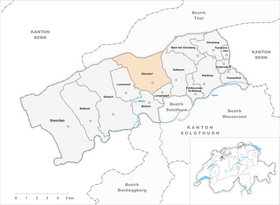
| Location of the municipality | |
  |
|
Oberdorf is a municipality in the Swiss canton of Solothurn , Lebern district .
geography
Oberdorf lies at 559 m above sea level. M. , 3.5 km northwest of the canton capital Solothurn (air line). The original street line village stretches out in a panoramic location on both sides of the torrent, at the southern foot of the Jura , at the foot of the Weissenstein .
The area of the 11.9 km² municipal area covers a section of the southern slopes of the Jura. The lower part of the community lies on a terrace sloping slightly to the south towards the Aare valley , which is bordered in the south by the Heimlisberg forest crest and in the west by the valley of the Bellacher Dorfbach brook. The Busletenwald to the west of this valley cut also still belongs to Oberdorf. At about the level of the village center, a meadow dome runs parallel to the Weissenstein chain, which is a lateral moraine of the Ice Age Rhone glacier . It was divided into two parts by the erosion force of the torrent .
The larger northern part of the municipality includes the Weissenstein chain with strong relief and numerous rock bands. The southern slope of the Weissenstein is subdivided by the source areas of the torrent, which rises in the Chlus , a clearing basin on the southern slope of the Weissenstein, and the Chesselbach (which also forms the eastern border of Oberdorf). Both streams flow through gorges dug deep into the hard Malm limestone layers of Geissflue and Vorberg to the south of the Aare. The Weissenstein with the Kurhaus ( 1284 m above sea level ) is also on the floor of Oberdorf. The northern border runs on the forest ridge with the Hächler ( 1283 m above sea level ) and the Dilitschkopf, on which at 1333 m above sea level. M. the highest point of Oberdorf is reached.
The clearing cauldron of the Rüschgraben north of the ridge of the foremost Jura range between Dilitschkopf and Hasenmatt also belongs to Oberdorf. As a result of the erosion, a so-called semicircle has formed here, in which the hard and softer rock layers of the Weissenstein anticlines are well exposed. The Rüschgrabenbach flows to Gänsbrunnen and drains over the Raus to the Birs . In 1997, 6% of the municipal area was accounted for by settlements, 68% for forests and woodlands and 25% for agriculture.
Oberdorf has a number of individual farms as well as the Kurhaus Weissenstein ( 1284 m above sea level ) and the Hinter Weissenstein mountain restaurant ( 1226 m above sea level ) below the entrance to the Nidlenloch cave . Neighboring communities of Oberdorf are Rüttenen , Langendorf , Bellach , Lommiswil , Selzach , Gänsbrunnen and Welschenrohr . Due to the lively residential construction activity, the settlement area of Oberdorf has grown together almost completely with that of Langendorf.
population
With 1724 inhabitants (as of December 31, 2018) Oberdorf is one of the medium-sized communities in the canton of Solothurn. 94.7% of the residents speak German, 1.2% speak French and 0.8% speak Italian and 0.4% speak Croatian (as of 2000). The population of Oberdorf was 585 in 1850 and 750 in 1900. In the course of the 20th century, the population rose to 1,037 by 1920, after which it remained relatively constant for a long time. Since 1980 (1169 inhabitants) there has been a significant increase in population.
economy


Up until the 20th century, Oberdorf was predominantly an agricultural village. The water power of the torrent was previously used to operate several mills. Limestone is or was quarried in several quarries above the village.
Even today, agriculture , animal husbandry and forestry have a certain role in the income structure of the population. Numerous other jobs are available in local small businesses and in the service sector. Wood processing companies (sawmills, carpenters), construction and transport, horticulture, IT and precision engineering workshops are represented in the community today. In the last few decades the village has developed into a residential community thanks to its attractive location. Many employed people are therefore commuters who mainly work in the Solothurn region.
leisure

The Weissenstein with its spa house and restaurant is a popular excursion destination in the region. On clear days, there is a wide panorama of the Swiss plateau and the Alps from Mont Blanc to Säntis .
In the border area between Oberdorf and Lommiswil, on the southern slope of the Jura, lies the quarry with the Lommiswil dinosaur slab . The tracks were left by brachiosaurs around 145 million years ago in the sand along a tropical shallow sea that covered large parts of Central Europe at the time. The quarry can be reached on foot in around 20 minutes from the BLS stop in Im Holz or Oberdorf .
traffic
The community is located away from the major thoroughfares, but is easily accessible from Solothurn . The closest connection to the A5 motorway (Solothurn-Biel) is around 5 km from the town center. On August 1, 1908, the Solothurn – Moutier line of the Solothurn-Münster Railway from Solothurn to Moutier with a station in Oberdorf went into operation. This train station is located directly in front of the south portal of the 3.8 km long Weissenstein tunnel . From here the Kurhaus Weissenstein can be easily reached with the Oberdorf – Weissenstein cable car ; From 2009 to 2014, due to disputes about the new construction of the Weissenstein cable car, a bus replacement was carried out with Postbuses, which only ran in the summer half of the year. Since December 2014, a gondola lift has opened up the Weissenstein, the valley station of which is next to the Oberdorf train station. The BSU bus line , which operates the route from Oberdorf via Solothurn to Recherswil , ensures the fine distribution of public transport .
history
The first known documentary mention of the place took place in 1305 under the name Oberdorf; from 1327 the name Oberndorf has been handed down. The meaning "upper village" refers to Langendorf, also on the torrent, but further down.
In the Middle Ages, Oberdorf was subordinate to the Sankt-Ursen-Stift in Solothurn and in 1344 came to the city of Solothurn, which from then on exercised both lower and higher jurisdiction. From 1487 the village was subordinate to the Vogtei Flumenthal and formed a court circle. After the collapse of the Ancien Régime (1798), Oberdorf belonged to the Solothurn administrative district during the Helvetic and from 1803 to the Lebern district.
Attractions

The Marien-Pilgrimage Church of Oberdorf with its east choir was built around 1420 on the site of an older chapel. It underwent a major redesign in 1604, when the new nave with the choir was built in the south, while the old system was integrated into the aisle church. The church has a rich interior with a magnificent pulpit, Wessobrunn stucco (from 1678) as well as Baroque altars and paintings.
Next to the church is the late Gothic St. Michael cemetery chapel from 1613.
Personalities
- Anastasius Adam (1795–1848), minority clergyman
- Ernst Burren (* 1944), dialect writer
- Damian Meier (* 1973), singer
- Thomas Wallner (* 1938), historian and councilor
coat of arms
- In blue and white floating St. Michael in his right hand the sword, in the left the scales
Web links
- Official website of the municipality of Oberdorf
- Urs Zurschmiede: Oberdorf (SO). In: Historical Lexicon of Switzerland .
- Aerial views of the village
Individual evidence
- ↑ Permanent and non-permanent resident population by year, canton, district, municipality, population type and gender (permanent resident population). In: bfs. admin.ch . Federal Statistical Office (FSO), August 31, 2019, accessed on December 22, 2019 .
- ^ Rolf Max Kully: Solothurn place names. The names of the cantons, the districts and the municipalities (= Solothurn name book. Volume I). Solothurn 2006, p. 528.
- ^ Gottlieb Loertscher: Parish and pilgrimage church Oberdorf SO. (Swiss Art Guide, No. 361). Ed. Society for Swiss Art History GSK. Bern 1984, ISBN 978-3-85782-361-9 .
Balm near Günsberg |
Bellach |
Bettlach |
Feldbrunnen-St. Niklaus |
Flumenthal |
Grenchen |
Günsberg |
Hubersdorf |
Chamber tube |
Langendorf |
Lommiswil |
Oberdorf |
Riedholz |
Rüttenen |
Selzach
Former municipality:
Niederwil
Canton of Solothurn | Districts of the Canton of Solothurn | Municipalities of the Canton of Solothurn