
Livers district
| Livers district | |
|---|---|
 |
|
| Basic data | |
| Country: |
|
| Canton : |
|
| Main town : | Grenchen |
| FSO number : | 1107 |
| Area : | 117.17 km² |
| Height range : | 417–1445 m above sea level M. |
| Residents: | 45,870 (December 31, 2018) |
| Population density : | 391 inhabitants per km² |
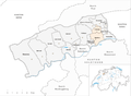
| map | |
 |
|
The Lebern district in the canton of Solothurn consists of the city of Grenchen and its surroundings, the western, northern and eastern parts of the surroundings of the city of Solothurn and the rural communities in the east of the district. It belongs to the Amtei Solothurn-Lebern , the capital is Grenchen.
coat of arms
- In red gold stake, covered with two and a half black, straight rafters . The rafters symbolize the Jura mountain range .
history
In the older history of the southern part of the Solothurn canton (area at the Jura-Südfuss), the "Leberberg" occupies a special position. During the time of the tribal duchy of Burgundy in the early Middle Ages, together with the region around Biel, it was a cut of this duchy into the tribal duchy of Alemannia . This can be traced back to the Burgundian immigration to around Solothurn in this then otherwise Alemannic area. Above all, the place names with the ending -ach still point to these Burgundian traces.
From around 1400 until the Helvetic Revolution in 1798, Lebern was - albeit partly under a different name - a bailiwick of the canton of Solothurn. From 1798 to 1831 Lebern was part of what was then the Biberist district. Lebern has existed as a separate district since 1831.
Municipalities
As of January 1, 2011
| coat of arms | Name of the parish | Population (December 31, 2018) |
Area in km² |
Inhabitants per km² |
|---|---|---|---|---|
|
|
Balm near Günsberg | 205 | 5.47 | 37 |
|
|
Bellach | 5213 | 5.29 | 985 |
|
|
Bed laugh | 4911 | 12.19 | 403 |
|
|
Feldbrunnen-St. Niklaus | 982 | 2.51 | 391 |
|
|
Flumenthal | 976 | 3.11 | 314 |
|
|
Grenchen | 17'372 | 26.03 | 667 |
|
|
Gunsberg | 1175 | 5.26 | 223 |
|
|
Hubersdorf | 747 | 1.35 | 553 |
|
|
Chamber tube | 28 | 0.95 | 29 |
|
|
Langendorf | 3782 | 1.95 | 1939 |
|
|
Lommiswil | 1536 | 5.76 | 267 |
|
|
Oberdorf (SO) | 1724 | 11.91 | 145 |
|
|
Riedholz | 2310 | 7.15 | 323 |
|
|
Rüttenen | 1462 | 8.77 | 167 |
|
|
Selzach | 3447 | 19.47 | 177 |
| Total (15) | 45,870 | 117.17 | 391 | |
Classification
Today the district is usually divided into three areas:
- in the Oberleberberg with the communities Grenchen, Bettlach (these two belong to the agglomeration Grenchen) and Selzach
- in the middle Leberberg with the communities Bellach, Lommiswil, Langendorf, Oberdorf and Rüttenen.
- and in the Unterleberberg with the rural communities Feldbrunnen-St. Niklaus, the eastern part of the municipality of Rüttenen, Balm bei Günsberg, Riedholz, Hubersdorf (these five still belong to the Solothurn agglomeration), Flumenthal, Kammersrohr, Günsberg and Niederwil
Changes in the community
Municipalities until 2010

Web links
- Othmar Noser: Livers. In: Historical Lexicon of Switzerland .
Individual evidence
- ↑ Permanent and non-permanent resident population by year, canton, district, municipality, population type and gender (permanent resident population). In: bfs. admin.ch . Federal Statistical Office (FSO), August 31, 2019, accessed on December 22, 2019 .
- ↑ H.Sigrist et al .: History of the canton of Solothurn, Volume 1: districts Solothurn and livers, 1947
- ↑ Federal Statistical Office Generalized Limits 2020.