
Aedermannsdorf
| Aedermannsdorf | |
|---|---|
 |
|
| State : |
|
| Canton : |
|
| District : | Thal |
| BFS no. : | 2421 |
| Postal code : | 4714 |
| Coordinates : | 613 045 / 239 577 |
| Height : | 531 m above sea level M. |
| Height range : | 502–1239 m above sea level M. |
| Area : | 12.92 km² |
| Residents: | 570 (December 31, 2018) |
| Population density : | 44 inhabitants per km² |
| Website: | www.aedermannsdorf.ch |
 Aedermannsdorf |
|
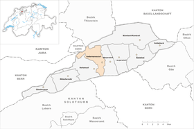
| Location of the municipality | |
  |
|
Aedermannsdorf (in local dialect : [ ˈæːdmiʃˌdɔː (r) fː ] / [ ˈæːdərmanːʃˌdɔː (r) fː ]) is a political municipality in the district of Thal in the canton of Solothurn in Switzerland .
geography
Aedermannsdorf lies at 531 m above sea level. M. , 7 km west of the district capital Balsthal ( linear distance ). The clustered village extends in a hollow of the Meisebach , on the sunny side on the northern edge of the Balsthalertal, at the foot of the Brunnersberg range in the Solothurn Jura .
The area of the 12.9 km² municipal area comprises a section in the western part of the Balsthaler or Dünner valley, a longitudinal valley in the Solothurn Jura. The central part of the area is taken up by the approximately 500 m wide flat valley floor of the Dünnern . To the south, the community ban extends to the anticline of the Weissenstein chain and includes the densely wooded, steep northern slope of the Rüttelhorn ( 1193 m above sea level ) between the two erosion valleys Riedgraben in the west and Horngraben in the east, which are cut into the hard limestone layers .
The Aedermannsdorf basin, through which the Meisebach flows, connects to the north of the Dünner valley. Further to the north, the municipality extends over the initially relatively gently rising slope to the anticline of the Brunnersberg range with the heights of Karlisberg ( 1171 m above sea level ), Zentner (at 1238 m above sea level, the highest elevation in Aedermannsdorf) and the rocky Geissflue ( 1102 m above sea level ). A small part in the upper catchment area of the Guldental also belongs to Aedermannsdorf. The northwestern border is the at Scheltenpass lying Matze villages Stierenberg ( 1222 m above sea level. M. ). With a narrow tip in the far west, the community area extends into the strongly chambered area at the farms of Solterschwang in the source area of the Gabiare (tributary of the Scheltenbach ). In 1997, 3% of the municipal area was accounted for by settlements, 47% for forests and woodlands and 50% for agriculture.
Aedermannsdorf has numerous individual farms, which are widely scattered in the Balsthalertal and on the heights of the Brunnersberg range. Neighboring communities of Aedermannsdorf are Beinwil , Mümliswil-Ramiswil , Matzendorf and Herbetswil in the canton of Solothurn and Rumisberg , Seehof and Schelten in the canton of Bern .
population
With 570 inhabitants (as of December 31, 2018), Aedermannsdorf is one of the smaller communities in the canton of Solothurn. Aedermannsdorf had 486 inhabitants in 1850, compared to 476 in 1900. In the course of the 20th century the population fluctuated between 450 and 550 inhabitants. Since 1980 (461 inhabitants) the population has increased again.
economy
Until the second half of the 20th century, Aedermannsdorf was predominantly an agricultural village. In the course of the 16th century, the heights of the Brunnersberg range were cleared, extensive summer pastures were created for the cattle and several dairy farms were built. Iron smelting has existed at Aedermannsdorf since the Middle Ages . In the 18th century weaving was widespread and from 1840 trimmings were done at home, often as an additional income besides farming.
Even today, arable farming in the lower elevations, as well as dairy farming and cattle breeding in the upper parts of the municipality, play an important role in the income structure of the population. Further jobs are available in local small businesses and in the service sector. In Aedermannsdorf there are companies involved in wood construction and wood processing, the building trade and agricultural machinery, as well as an earthenware and porcelain factory (which emerged from the former faience factory in 1961). In the last few decades the village has also developed into a residential community. Many employed people are therefore commuters who mainly work in Balsthal and in the Olten-Solothurn area.
traffic
The community is very well developed in terms of transport. It is around 1 kilometer from the main road from Oensingen to Moutier . Aedermannsdorf is connected to the public transport network through a post bus course that covers the route from Balsthal to Gänsbrunnen .
history

The first written mention of the place took place in 1308 as Odermarstorf ; later the name appears in the variants Edermansdorf (1318), Edelmanstorff (1406), Edermarstorf (1494) & c. The place name goes back to a combination of the Old High German personal name * Adermar or Odermar and the basic word village 'Weiler, Hof, Dorf, Gut, Stadtviertel', which is common in Alemannic settlement names .
In the Middle Ages , Aedermannsdorf belonged to the Neu-Falkenstein lordship. In 1420 the place came under the rule of Solothurn through purchase and was assigned to the Landvogtei Falkenstein. Various iron smelters have existed in the area of the village since the 15th century. In 1779 the hammer forge was founded on the Dünnern, where weapons, pans and tools were forged.
After the collapse of the Ancien Régime (1798), Aedermannsdorf was assigned to the Balsthal-Thal district. Also in 1798, Ludwig von Roll founded a faience factory that produced high quality earthenware and faience tableware. In the 19th century, especially from 1850 to around 1870, the valley was affected by severe poverty and famine, so that many residents had to emigrate. The hammer forge was abandoned in 1841, and the buildings then housed a tannery, a spinning mill and a watch shell factory, which no longer exist today.
Attractions
With the construction of the parish church of St. Joseph , Aedermannsdorf became an independent parish in 1967; before it belonged to the parish Matzendorf. The oldest farmhouse in the village is the Gallihaus, which dates back to 1510; the Joseph Chapel was built in 1691. In Horngraben the Sankt Antoniuskapelle stands near a hermitage, which was founded around 1450.
photos

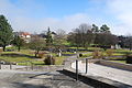
Village center with village fountain

Catholic Church of St. Joseph

St. Joseph's Chapel
graveyard

Parish hall

school


coat of arms
- In white a red angular left angle measure
literature
- Gottlieb Loertscher: The art monuments of the canton of Solothurn, Volume III: The districts of Thal, Thierstein, Dorneck. (= Art Monuments of Switzerland. Volume 38). Edited by the Society for Swiss Art History GSK. Bern 1957, DNB 750089342 .
- Albert Vogt: Aedermannsdorf. Population, economy, society and culture in the 19th century. Chronos-Verlag Zurich, 2003. 772 pp. ISBN 3-0340-0579-2 .
- Albert Vogt: 700 years of Aedermannsdorf. 1308-2008. Aedermannsdorf 2008. 223 pp.
Web links
- Official website of the municipality of Aedermannsdorf
- Albert Vogt: Aedermannsdorf. In: Historical Lexicon of Switzerland .
- Aerial views of the village
Individual evidence
- ↑ Permanent and non-permanent resident population by year, canton, district, municipality, population type and gender (permanent resident population). In: bfs. admin.ch . Federal Statistical Office (FSO), August 31, 2019, accessed on December 22, 2019 .
- ↑ a b Gabrielle Schmid: Ädermannsdorf SO (Thal) in: Dictionnaire toponymique des communes suisses - Lexicon of Swiss community names - Dizionario toponomastico dei comuni svizzeri (DTS | LSG). Center de dialectologie, Université de Neuchâtel, Verlag Huber, Frauenfeld / Stuttgart / Vienna 2005, ISBN 3-7193-1308-5 and Éditions Payot, Lausanne 2005, ISBN 2-601-03336-3 , p. 75.