
Eriswil
| Eriswil | |
|---|---|
 |
|
| State : |
|
| Canton : |
|
| Administrative district : | Oberaargau |
| BFS no. : | 0953 |
| Postal code : | 4952 |
| Coordinates : | 631 239 / 214 784 |
| Height : | 740 m above sea level M. |
| Height range : | 705–1139 m above sea level M. |
| Area : | 11.34 km² |
| Residents: | 1396 (December 31, 2018) |
| Population density : | 123 inhabitants per km² |
| Website: | www.eriswil.ch |
_140.JPG) Village fountain in the center of Eriswil |
|
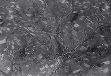
| Location of the municipality | |
  |
|
Eriswil is a municipality in the Oberaargau administrative district in the canton of Bern in Switzerland .
geography
The municipal area primarily comprises the uppermost part of the Langetetal . Its eastern municipality border is also the canton border with the canton of Lucerne . To the east of the municipality are the municipalities of Luthern and Ufhusen , Huttwil in the north , Wyssachen in the west and Wasen, Sumiswald municipality in the south .
The Langete, which gives its name to the long valley with the main town of Langenthal , also rises from the Eriswil municipality, which, in addition to the town center, is largely made up of agricultural land, pasture land and forest .
traffic
The municipality is only accessible by connecting roads.
On September 1, 1915, the Huttwil – Eriswil line was opened. Passenger traffic on this route was stopped on May 31, 1975 and canceled on May 27, 1978, then canceled. Instead of the railway line, there is now a bus line from Huttwil to Eriswil (timetable 30.491).
coat of arms
- In red a green floating six mountain (1: 2: 3 mountains)
The coat of arms corresponds to that of the Barons von Grünenberg , whose coat of arms is in silver. Eriswil belonged to them in the 14th century as part of the Rohrbach BE rule .
photos
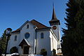
Reformed Church Eriswil

Stained glass in the church

Fritzenfluh mountain restaurant

Old railway bridge over the Langete

The Langete in the village center

school
_142.JPG)
_144.JPG)
_178.JPG)
_128.JPG)
_165.JPG)
_170.JPG)
See also
Web links
- Official website of the municipality of Eriswil
- Anne-Marie Dubler : Eriswil. In: Historical Lexicon of Switzerland .
Individual evidence
- ↑ Permanent resident population from STAT-TAB of the BfS , municipalities see also regional portraits 2020 on bfs.admin.ch, accessed on May 29, 2020
- ↑ Swiss course book 2009 edition.
Aarwangen | Attiswil | Exit | Bannwil | Berken | Bettenhausen | Bleienbach | Busswil near Melchnau | Eriswil | Farners | Gondiswil | Dig | Heimenhausen | Herzogenbuchsee | Huttwil | Inkwil | Langenthal | Lotzwil | Madiswil | Melchnau | Niederbipp | Niederönz | Oberbipp | Top stake | Ochlenberg | Oeschenbach | Reisiswil | Roggwil | Rohrbach | Rohrbachgraben | Rumisberg | Rütschelen | Black Houses | Seeberg | Foolish | Thunstetten | Ursenbach | Walliswil near Niederbipp | Walliswil near Wangen | Walterswil | Wangen an der Aare | Wangenried | Wiedlisbach | Wynau | Wyssachen
Former municipalities: Bollodingen | Gutenburg | Hermiswil | Kleindietwil | Leimiswil | Oberönz | Röthenbach near Herzogenbuchsee | Shear | Undercut wood | Wanzwil | Wolfisberg
Canton of Bern | Administrative districts of the canton of Bern | Municipalities of the Canton of Bern