
Berken
| Berken | |
|---|---|
 |
|
| State : |
|
| Canton : |
|
| Administrative district : | Oberaargau |
| BFS no. : | 0972 |
| Postal code : | 3376 |
| Coordinates : | 620610 / 230750 |
| Height : | 419 m above sea level M. |
| Height range : | 417–458 m above sea level M. |
| Area : | 1.39 km² |
| Residents: | 45 (December 31, 2018) |
| Population density : | 32 inhabitants per km² |
|
Proportion of foreigners : (residents without citizenship ) |
0.0% (2,011) |
| Website: | www.berken.ch |
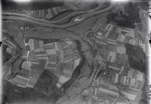
_077.JPG) View of the Aare with various communities, including Berken (above the forest to the right of the center of the picture) |
|
| Location of the municipality | |
  |
|
Berken ( Bern German [bɛːrkχə] ) is a municipality in the Swiss canton of Bern . It is located in the Oberaargau administrative district .
geography
Berken lies at 420 m above sea level. M. , 6 km west of the city of Langenthal (linear distance). The farming village extends in the valley of the Aare south of the river, in Oberaargau .
The area of the 1.4 km² large municipal area covers a section of the northern Bernese Mittelland . The northern boundary of the municipality is formed by the Aare, which over the years has dug a valley around 30 m deep into the gravel plain. From the Aare, the community ban extends southward over the lower terrace (around 420 m above sea level ) to the clearly delimited high terrace (around 445 m above sea level ). The high terrace is subdivided by the valley of the Seebach , the outflow from the Inkwilersee . The south-western part of the municipality is occupied by the extensive Berkerwald , in which at 458 m above sea level. M. the highest point of Berken is reached. In 1997, 11% of the municipal area was in settlements, 31% in forests and woodlands, 52% in agriculture and a little less than 6% was unproductive land.
Berken consists of the hamlet settlements Unterberken ( 420 m above sea level ) and Christenhof ( 430 m above sea level ) in the valley south of the Aare, and Oberberken ( 446 m above sea level ) on the high terrace west of the Seebach valley . The neighboring communities of Berken are Graben , Heimenhausen , Walliswil bei Wangen , Walliswil bei Niederbipp and Bannwil .
population
With 45 inhabitants (as of December 31, 2018) Berken is one of the smallest communities in the canton of Bern. In 2000, 100% of the residents stated German as their mother tongue. The population of Berken was 77 in 1850 and 114 in 1900. In the course of the 20th century the population decreased by more than 50% due to heavy emigration.
Water supply
The water supply is the responsibility of the municipal association of water supply on the lower Oenz (WVOe). Like many other water suppliers, the WVOe has to contend with chlorothalonil metabolites . Water samples from 2019 showed that the applicable maximum values were exceeded in four of the WVOe's drinking water catchments. As a result of the heat and drought in 2019 , customers were asked in July of the same year to limit their water consumption .
economy
Berken was a predominantly agricultural village until the second half of the 20th century . Even today, agriculture and dairy farming as well as forestry have an important place in the income structure of the population. Further jobs are available in local small businesses and in the service sector. A gravel pit is being exploited east of Oberberken. Some workers are commuters who mainly work in the Langenthal-Herzogenbuchsee region.
traffic
The community is located off the major thoroughfare on a connecting road from Wangen an der Aare to Langenthal . Berken also has a crossing over the Aare. The next connection to the A1 motorway (Bern – Zurich) is around 5 km from the town center. The village has no connection to the public transport network.
history
Individual finds from the Mesolithic and the Neolithic indicate a very early settlement of today's municipal area. The oldest known mention of the place comes from documents from 1272, where Berinkon and Berinchoven are mentioned. Later names are about Berikofen (1358), Beronkon (1359), Berikon (1365) and Bercken (1432). It is based on a developed (that is, not handed down) Old High German Bëringhofen, which means "at the courts of the people of Bero". Place names ending in -iken, -ikon, -ikofen are typical for Alemannic settlements founded in the 7th and 8th centuries .
Since the Middle Ages Berken has been under the rule of Aarwangen . After the family of the Lords of Aarwangen had died out, the village came in 1341 to the Barons of Grünenberg ( Melchnau ), also a family of Habsburg servants . By purchase, Berken came under Bern rule in 1432 and was assigned to the Aarwangen bailiff. After the collapse of the Ancien Régime (1798), Berken belonged to the district of Wangen during the Helvetic Republic and from 1803 to the Oberamt Wangen, which received the status of an official district with the new cantonal constitution of 1831. Berken does not have its own church; it belongs to the Herzogenbuchsee parish .
See also
literature
Web links
Individual evidence
- ↑ Permanent resident population from STAT-TAB of the BfS , municipalities see also regional portraits 2020 on bfs.admin.ch, accessed on May 29, 2020
- ↑ Population growth continues . Press release. Federal Statistical Office . April 26, 2012. Retrieved July 17, 2012.
- ↑ a b Place name book of the canton of Bern , Part I, Volume 1, p. 277.
- ↑ http://www.wasserversorgung-oenz.ch/Versorgungsgebiet.htm
- ↑ https://www.vol.be.ch/vol/de/index/direktion/organisation/kl/publikationen/Mitteilungen.assetref/dam/documents/VOL/KL/de/mitteilungen_result_chlorothalonil.pdf
- ↑ https://www.be.ch/portal/de/index/mediencenter/medienmitteilungen.meldungNeu.html/portal/de/mektiven/mm/2020/02/20200206_0921_chlorothalonil-metabolitenimtrinkwasserkantonpubliziertdiemesswe
- ↑ http://www.wasserversorgung-oenz.ch/view/data/5730/Sparsames%20Umiegen%20mit%20Wasser.pdf
Aarwangen | Attiswil | Exit | Bannwil | Berken | Bettenhausen | Bleienbach | Busswil near Melchnau | Eriswil | Farners | Gondiswil | Dig | Heimenhausen | Herzogenbuchsee | Huttwil | Inkwil | Langenthal | Lotzwil | Madiswil | Melchnau | Niederbipp | Niederönz | Oberbipp | Top stake | Ochlenberg | Oeschenbach | Reisiswil | Roggwil | Rohrbach | Rohrbachgraben | Rumisberg | Rütschelen | Black Houses | Seeberg | Foolish | Thunstetten | Ursenbach | Walliswil near Niederbipp | Walliswil near Wangen | Walterswil | Wangen an der Aare | Wangenried | Wiedlisbach | Wynau | Wyssachen
Former municipalities: Bollodingen | Gutenburg | Hermiswil | Kleindietwil | Leimiswil | Oberönz | Röthenbach near Herzogenbuchsee | Shear | Undercut wood | Wanzwil | Wolfisberg
Canton of Bern | Administrative districts of the canton of Bern | Municipalities of the Canton of Bern