List of cultural assets in Brittnau
The list of cultural assets in Brittnau contains all objects in the municipality of Brittnau in the canton of Aargau that are subject to the Hague Convention for the Protection of Cultural Property in the Event of Armed Conflict , the Federal Act of June 20, 2014 on the Protection of Cultural Property in the Event of Armed Conflict and the Ordinance of 29 June 2014 October 2014 on the protection of cultural property in the event of armed conflict .
Objects of category A are not shown in the municipality, objects of category B are fully included in the list, objects of category C are currently missing (as of January 1, 2018). Other protected objects can be found under other monuments , which are recorded in the building and usage regulations of the municipality and are not already included in the list of cultural assets.
Cultural assets
| photo | object | Cat. | Type | Location | description |
|---|---|---|---|---|---|

|
House no.70 KGS no .: 15278 |
B. | G | Strählgasse 12 638 708 / 234466 |
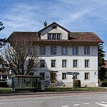
Prestigious house built in 1808 in the classical style with a mansard roof , rusticated corner pilasters and a profiled belt and main cornice.
|

|
Storage tank KGS no .: 15279 |
B. | G | Ausserdorf six hundred and thirty-eight thousand four hundred and three / 234561 |
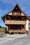
1752 erbauter granary . Wooden stand construction under a bent gable roof and with an all-round arbor.
|

|
Reformed Church KGS-No .: 15280 |
B. | G | Dorfstrasse 92 six hundred and thirty-eight thousand five hundred and sixty-seven / 234337 |
Church building built in the 16th century in late Gothic style (tower from 1585); Parts of the north wall date from 10/11. Century.
|

|
Mühle KGS no .: 15281 |
B. | G | Zur Mühle 64 638 711 / 234632 |
Mill built in 1603 (rebuilt in 1702). Plastered four-storey building of the wall under kinked gable roof with EASONS and carved Bügen . On the east side there is an octagonal stair tower under an angular pointed helmet .
|
Other monuments
| ID | photo | object | Type | address | Coordinates |
|---|---|---|---|---|---|
| 1 |

|
Old school house (1829) | G | Dorfstrasse 11 |
638447 / 234429
|
| 2 |

|
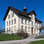
District school building (1909) | G | village street |
638378 / 234394
|
| 3 |

|
Gasthof Sonne (1821) | G | Dorfstrasse 6 |
638490 / 234275
|
| 4th |

|
House (1801) | G | Dorfstrasse 12 |
638537 / 234377
|
| 5 |

|
Farmhouse No. 95, residential part | G | Grienmattweg 1 |
638624 / 234271
|
| 6th |

|
High-rise (16th / 17th century) | G | Dorfstrasse 36 |
638293 / 234552
|
| 7th | Farmhouse (1846) | G | Dorfstrasse 17 |
638355 / 234502
|
|
| 8th | Storage (1789) | G | way to school |
638377 / 234477
|
|
| 9 |

|
Storage (1757) | G | Mühlackerweg 5 |
638845 / 234418
|
| 10 | Farmhouse (around 1810) | G | Zofingerstrasse 47 |
638534 / 236092
|
|
| 11 | Stöckli (early 19th century) | G | Zofingerstrasse 47 |
638542 / 236071
|
|
| 12 | Weaving house (around 1800) | G | Altweg 3 |
638411 / 234262
|
|
| 13 | Farmhouse (late 18th century) | G | Weiherweg 2 |
637722 / 234201
|
|
| 14th |

|
Schoolhouse (1902/03) | G | Mattenwil, Bögligasse |
636038 / 233421
|
| 15th |

|
Old school house (1795) | G | Mattenwil, Bögligasse |
|
| 16 |

|
Granary (18th century) | G | Mattenwil, Bögligasse |
|
| 17th |

|
Residential house (former forge, around 1800) | G | Mattenwil, Mattenwilerstrasse |
635893 / 233208
|
| 18th | Speicher (around 1750) | G | Mattenwil, Stampfi |
|
|
| 19th | Stoeckli (1778) | G | Upper Geissbachweg |
|
|
| 20th | Granary (1781) | G | Upper Geissbachweg |
|
|
| 21st | Farmhouse (around 1850) | G | Mattenwil, Unterer Sennhof |
|
|
| 22nd | Speicher (around 1750) | G | Grod, Bötschenbühlweg |
|
|
| 23 | Storage / furnace house (1826) | G | Liebigen, Liebigenweg |
|
|
| 24 | Stöckli (around 1820/30) | G | Liebigen, Pfaffnauerstrasse |
|
|
| 26th | High-rise | G | Liebigen, Hönetenweg |
|
|
| 27 | Double store (late 18th century) | G | Oberliebigen, Tommenhubelweg |
|
|
| 28 | High study building (18th century) | G | Oberliebigen, Tommenhubelweg |
|
|
| 29 | Granary (18th century) | G | Wiggerhöfe |
|
|
| 30th |

|
Syringe house | G | Mattenwilerstrasse |
|
| A4 | Memory (1752) | G | Hausmattweg 1 |
638412 / 234583
|
Legend: See the legend of the list of cultural objects of national and regional importance. Instead of the KGS number, the inventory or building number in the building and usage regulations of the municipality is used as the object identifier (ID).
Web links
- A – Objects AG 2018 . Swiss inventory of cultural assets of national importance. In: babs.admin.ch / kulturgueterschutz.ch. Federal Office for Civil Protection FOCP - Department of Cultural Property Protection, January 1, 2018, accessed on December 26, 2017 (PDF; 127 kB, 23 pages, updated annually, no changes for 2018).
- B-Objects AG 2018 . Canton Aargau KGS inventory, B objects, status: 1.1.2018 (no changes compared to the previous year). In: babs.admin.ch / kulturgueterschutz.ch. Federal Office for Civil Protection FOCP - Department of Cultural Property Protection, January 1, 2018, accessed on December 30, 2017 (PDF; 677 kB, 27 pages, updated annually, no changes for 2018).
- Building and usage regulations Brittnau (PDF, 288 kB)
Individual evidence
- ↑ Federal Chancellery : Federal Act on the Protection of Cultural Property in the Event of Armed Conflict, Disaster and Emergencies (KGSG). SR 520.3. In: Systematic Legal Collection SR . Federal Assembly of the Swiss Confederation , June 20, 2014, accessed on September 7, 2017 (as of January 1, 2016).
- ^ Federal Chancellery : Ordinance on the Protection of Cultural Property in the Event of Armed Conflicts, Disasters and Emergencies (KGSV). SR 520.31. In: Systematic Legal Collection SR . Swiss Federal Council , October 29, 2014, accessed on September 7, 2017 (as of January 1, 2016).
- ↑ Strählgasse 12 in the inventory of historical monuments of the canton Aargau
- ↑ Storage in the inventory of historical monuments of the Canton of Aargau
- ↑ Ev.-ref. Parish church in the inventory of the canton Aargau
- ↑ Mill in the inventory of historical monuments of the Canton of Aargau