
Trimbach SO
| SO is the abbreviation for the canton of Solothurn in Switzerland and is used to avoid confusion with other entries of the name Trimbach . |
| Trimbach | |
|---|---|
 |
|
| State : |
|
| Canton : |
|
| District : | Gösgen |
| BFS no. : | 2500 |
| Postal code : | 4632 |
| Coordinates : | 634 852 / 245996 |
| Height : | 419 m above sea level M. |
| Height range : | 388–866 m above sea level M. |
| Area : | 7.60 km² |
| Residents: | 6552 (December 31, 2018) |
| Population density : | 862 inhabitants per km² |
| Website: | www.trimbach.ch |
 Trimbach seen from the Hauenstein Pass |
|
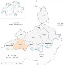
| Location of the municipality | |
  |
|
Trimbach is a municipality in the district of Gösgen in the canton of Solothurn in Switzerland .
geography

Trimbach lies at 419 m above sea level. M. , north of the city of Olten on the left side on the Aare at the southern foot of the Jura . The original village center, a typical street village, extends in a side valley of the Aare at the starting point of the pass road of the Lower Hauenstein .
The 7.7 km² municipal area covers a section of the Solothurn Jura and has a great variety of landscapes. The southeastern part of the municipality and the main settlement area of Trimbach is located in the 500 m wide valley of the Dorfbach . This valley depression is bounded in the south by the Chutzenflue ( 560 m above sea level ) and in the north by the Stellichopf ( 667 m above sea level ). It opens to the southeast to the valley of the Aare, which forms the municipal boundary between the canton hospital Olten and the sharp river bend at the Rankwog.
Towards the west and north, the municipality is characterized by a strongly reliefed terrain dominated by numerous striking rock formations and rivers. The Folded Jura has a geologically complex structure and is divided into various scales. The hard limestone layers form striking mountain ridges, while the softer marl and clay layers have been eroded over time and are now visible as valley widenings in the landscape. Particularly striking is the mountain ridge, which stretches from Homberg via Miserenflüe , Hegiberg and (Frohburger) Geissflue ( 813 m above sea level ) to the Frohburg castle and separates the Rintel basin from the Mulde near Trimbach. The Dorfbach has created a cleft- like breakthrough between the Miserenfluchten and the Hegiberg .
The southern border runs in the western part of the municipality on the Rumpelfluchten (up to 640 m above sea level ), the northern border on the Jura main ridge from the Wisnerhöchi ( 778 m above sea level ) north past Erlimoos over the forest height at the Frohburg restaurant (at 866 m above sea level ) above sea level the highest point of Trimbach) to the southern slope of the Dottenberg near the Frohburg transmission tower. To the west, the community area extends with a narrow corner into the ditch , a deep gorge below the Hauenstein pass. In 1997, 20% of the municipal area was in settlements, 54% in forests and woodlands, 25% in agriculture and a little more than 1% was unproductive land.
Trimbach includes the Rankwog settlement ( 400 m above sea level ) on the Aare bend at the south portal of the Hauenstein base tunnel, the hamlet of Düriberg ( 492 m above sea level ) on the southern slope of the Stellichopf and various individual farms. Trimbach's neighboring communities are Wisen , Lostorf , Winznau , Olten , Wangen bei Olten and Hauenstein-Ifenthal .
population
| year | 1850 | 1888 | 1900 | 1910 | 1930 | 1950 | 1960 | 1970 | 1980 | 1990 | 2000 |
| Residents | 1054 | 1390 | 2066 | 2513 | 3694 | 4622 | 5784 | 7649 | 7065 | 6700 | 6173 |
With 6552 inhabitants (as of December 31, 2018) Trimbach is one of the larger municipalities in the canton of Solothurn. 80.1% of the residents speak German, 7.0% speak Italian and 2.9% speak Turkish (as of 2000). The population of Trimbach has increased sharply since 1888. After a marked growth during the 1960s, the peak was reached in the early 1970s with around 7700 inhabitants. Since then, the population has decreased by almost 20%. The settlement area of Trimbach has grown together seamlessly with that of Olten.
politics
Municipal council
The Social Democratic Party has been the strongest party since 1945 . It reaches a share of the vote of around 40%. The Swiss People's Party first took part in the 2001 elections. After the elections to the local council for the 2009-2013 term, a complaint was made with suspicion of electoral fraud .
| Political party | 2013-2017 | (+/-) | 2009-2013 |
| Social Democratic Party | 2 | 2 | |
|
FDP. The Liberals ( Free Democratic Party until 2009 ) |
1 | 1 | |
| Swiss People's Party | 1 | 1 | |
| Christian Democratic People's Party | 1 | 1 |
Mayor

| year | Surname | Political party |
|---|---|---|
| 1900-1922 | Albert Lehmann | People's Party |
| 1923-1945 | Alphons von Felten | People's Party |
| 1945–1957 | Paul Berlinger | SP |
| 1957-1969 | Adolf Bader | People's Party / CVP |
| 1969-1975 | William Frey | SP |
| 1975-1983 | Josef Reichmuth | CVP |
| 1983-1997 | Ernst Gomm | SP |
| 1997-2009 | Martin Straumann | SP |
| 2009-2017 | Karl Tanner | SP |
| from 2017 | Martin Bühler | SP |
economy
Trimbach exhibited traditional handicrafts and trades in addition to agriculture early on. The water power of the village stream was used to operate mills, tanneries and sawmills. From the end of the 18th century, the textile industry also developed (initially mainly carried out at home). At the end of the 19th century, there was a rapid change to an industrial village on the northern edge of Olten, which was then primarily known for its railway workshops. Many working class families employed in these workshops settled in Trimbach, which led to a significant increase in population.
Today Trimbach offers around 1,600 jobs. With 3% of the gainfully employed who are still employed in the primary sector, agriculture (mainly cattle breeding , dairy farming and forestry ) only has a minor role in the employment structure of the population. Around 43% of the workforce is employed in the industrial sector, while the service sector accounts for 54% of the workforce (as of 2001).
The relatively small number of jobs compared to the number of inhabitants shows that Trimbach is now predominantly a suburb of Olten. Trade and industry concentrate on numerous small and medium-sized companies. A larger commercial and industrial area is located in the Grossfeld along the banks of the Aare. Trimbach's nationally known companies include Reize Optik AG (spectacle glass grinding), Velux Schweiz AG (window construction), Glas Trösch AG Trimbach, Schibli Möbel AG and Wernli AG (biscuit factory). In addition, numerous companies in the construction and transport industry, the electrical industry, information technology, wood processing, mechanical workshops and trading companies are represented.
The tertiary sector mainly focuses on sales, engineering, architecture and fiduciary offices, administration, insurance, education and catering. The Solothurn Cantonal Hospital is located on the municipal boundary between Olten and Trimbach. The former Kurhaus Froburg is now a restaurant and houses a technical school. Many of the employed people living in Trimbach commute to work in the city of Olten. New residential quarters have emerged in the last few decades, mainly on the panoramic south-facing slope of Dürrenberg and Stellichopf.
traffic
The community is very well developed in terms of transport. It is located on the main road 2 from Basel via Liestal over the Unteren Hauenstein to Olten . The nearest connection to the A1 motorway (Bern-Zurich) is around 7 km from the town center.
In 1858 the Hauenstein line was opened from Basel via Läufelfingen to Olten. The south portal of the approximately 2.5 km long Hauenstein summit tunnel is located west of Trimbach. The Trimbach stop was not set up by the SBB until January 8, 1916 with the opening of the Hauenstein base tunnel. It was moved from Sonnrain to Marenstrasse in 1960, but the old station building from 1915 has been preserved. The new Hauenstein line, which went into operation on January 8, 1916, with the 8.1 km long Hauenstein base tunnel also runs through the far east of the municipality. The BOGG bus routes ( Busbetrieb Olten Gösgen Gäu ), which operate the routes from Trimbach via Olten to Dulliken, from Olten to Wisen and from Olten via Trimbach to Gösgeramt, ensure the fine distribution of public transport .
history
The first written mention of the place took place in 1244 under the name Trinbach . Later the names Trimbach (1278) and Trümbach (1293) appeared. The etymology of the first part of the place name is obscure. Frohburg , located on a rock north of the village, was built in the 10th century and was the ancestral seat of the Counts of Frohburg , who ruled over the Buchsgau . With this castle the pass crossings of the Untere Hauenstein and the Erlimoospass were controlled. In the 13th century a family of ministers from Trimbach is mentioned.
After the Frohburger family had died out in 1367, Trimbach came to the Counts of Nidau, in 1375 as a Habsburg fief to the Thiersteiners and in 1418 to the Falkensteiners, who owned the Gösgen rule. The village came to the city of Solothurn by purchase in 1458 and was now assigned to the Bailiwick of Gösgen, in which it formed a court district. After the collapse of the Ancien Régime (1798), Trimbach belonged to the Solothurn administrative district during the Helvetic and from 1803 to the Gösgen district.
During the 19th century, the construction of the Hauenstein summit tunnel and later the Olten railway workshops led to strong population growth and an economic boom. At the end of the century, industry also gained a foothold in Trimbach. In the second half of the 20th century, Trimbach increasingly became a suburb of Olten.
In January 2020 it became known that the maximum levels of chlorothalonil in drinking water had been exceeded.
Religions
Hinduism
A Hindu temple in Trimbach was inaugurated in mid-March 2013. It is the first time that such a temple has been built in Switzerland.
Attractions
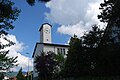
The St. Mauritius Church probably goes back to a foundation by the Frohburger. The church received its present shape with a cross-shaped floor plan when it was rebuilt between 1774 and 1776; In 1942 the church was redesigned. The Mauritius Church was taken over by the Christ Catholics during the Kulturkampf in 1873, but bought back in 1909 by the Catholic denomination, which had held its services in an emergency church from 1877 onwards.
The Trinity Chapel with a striking turret (pointed onion helmet) dates from the 15th century and served as a street chapel.
The Frohburg ruin is an excursion destination , from which there is a view of Olten and, if the weather is clear, the Alps.
coat of arms
- White red five-petalled rose with a yellow clump and green sepals
Personalities
- Hans Kunz (1904–1982), philosopher, psychologist and botanist
- Peter Rück (1934–2004), historian
- Valentino Ragni (* 1935), composer, pianist and music teacher
- Ramon Vega (* 1971), former national soccer player
- Kilian Ziegler (* 1984), slam poet and cabaret artist
photos

Catholic Church of St. Mauritius

Christ Catholic cruciform church with rectory
Reformed St. John's Church

Hindu temple in Trimbach

Farm mill

Geissfluh
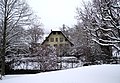
Trimbach old mill in winter
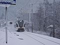
Trimbach stop on the old Hauenstein line Olten - Sissach


Web links
- Official website of the municipality of Trimbach
- Hans Brunner: Trimbach. In: Historical Lexicon of Switzerland .
Individual evidence
- ↑ Permanent and non-permanent resident population by year, canton, district, municipality, population type and gender (permanent resident population). In: bfs. admin.ch . Federal Statistical Office (FSO), August 31, 2019, accessed on December 22, 2019 .
- ↑ a b Renewal elections for 5 members of the municipal council for the 2013-2017 term of office (PDF; 21 kB)
- ↑ a b Homepage of the Trimbach community: Politics ( Memento of the original from July 4, 2013 in the Internet Archive ) Info: The archive link was inserted automatically and has not yet been checked. Please check the original and archive link according to the instructions and then remove this notice.
- ↑ State Chancellery of the Canton of Solothurn: Trimbach - criminal complaint because of suspected votes ( page no longer available , search in web archives ) Info: The link was automatically marked as defective. Please check the link according to the instructions and then remove this notice. (PDF; 21 kB)
- ↑ The upper Hauenstein line - railway construction since 1853. Architectural and technical history of the railways in Switzerland, Volume 2. Published by the SBB department for monument protection issues and GSK. Scheidegger & Spiess, Zurich 2009, ISBN 978-3-85881-287-2 , pp. 85–86, 142.
- ↑ Urs Huber: Negative examples Rickenbach and Trimbach: «K-Tip» publication on drinking water causes a stir. In: solothurnerzeitung.ch . January 22, 2020, accessed January 23, 2020 .
- ↑ The Hindu temple is solemnly inaugurated. Retrieved May 6, 2013 .
- ↑ Effective point - Harfenbergstrasse 17 - St.Gallen: Kilian Ziegler - artist - Dreh & angel. Retrieved September 14, 2017 .
Erlinsbach (SO) |
Hauenstein-Ifenthal |
Kienberg |
Lostorf |
Niedergösgen |
Obergösgen |
Pipe |
Stüsslingen |
Trimbach |
Winznau |
Wisen
Former communities: Niedererlinsbach | Obererlinsbach
Canton of Solothurn | Districts of the Canton of Solothurn | Municipalities of the Canton of Solothurn