
Wangen near Olten
| Wangen near Olten | |
|---|---|
 |
|
| State : |
|
| Canton : |
|
| District : | Olten |
| BFS no. : | 2586 |
| Postal code : | 4612 |
| Coordinates : | 632 557 / 243821 |
| Height : | 417 m above sea level M. |
| Height range : | 404–944 m above sea level M. |
| Area : | 6.96 km² |
| Residents: | 5057 (December 31, 2018) |
| Population density : | 727 inhabitants per km² |
| Website: | www.wangenbo.ch |
 Main street no. 5 in the center of Wangen near Olten |
|
| Location of the municipality | |
  |
|
Wangen bei Olten is a municipality in the Olten district in the canton of Solothurn in Switzerland .
geography

Wangen bei Olten is 417 m above sea level. M. , 2.5 km west-southwest of the district capital Olten (linear distance). The village extends in the wide hollow of the Dünnern at the southern foot of the Jura between the Homberg in the north and the Born in the south and connects to the west of Olten.
The area of the 6.9 km² large municipal area includes a section of the so-called Berggäus at the foot of the Jura. The central part of the area is occupied by the valley plain of the Dünnern, which is a little more than 1 km wide in the area of Wangen near Olten. The Dorfbach flows into this plain from the north from the Brändlistal with a small alluvial cone. To the north, the municipality extends over the initially relatively gentle, then steeply rising slopes in the upper part with the foothills Hügert to the west and Hochrüti ( 731 m above sea level ) to the east of the Brändlistal and extends to the Homberg . This mountain crest, which slopes down to the north with a rocky edge, forms the northern border of Wangen bei Olten and reaches 944 m above sea level. M. the highest point of the municipality.
South of the Dünner valley, the municipal ban extends to the densely wooded wide ridge of the Born, which is 719 m above sea level. M. culminates. The ridge area of the Born belongs entirely to Wangen bei Olten, the southern border runs on the edge in front of the steep drop towards the Aare . In 1997, 18% of the municipal area was accounted for by settlements, 54% for forests and woodlands and 28% for agriculture.
Wangen consists of two areas that used to be separated from each other during floods before the channeling of the river of the Dünne. On the one hand, this is Kleinwangen south of the Dünnern with a few individual farms, and on the other hand, Grosswangen north of the Dünnern. Neighboring communities of Wangen bei Olten are Olten , Kappel (SO) , Rickenbach (SO) , Hauenstein-Ifenthal and Trimbach .
population
With 5057 inhabitants (as of December 31, 2018), Wangen bei Olten is one of the medium-sized communities in the canton of Solothurn. 89.1% of the residents speak German, 2.3% speak Italian and 2.1% speak Serbo-Croatian (as of 2000). The population of Wangen bei Olten was 908 in 1850 and 1362 in 1900. In the course of the 20th century the population rose continuously to 4,177 people until 1970. After a temporary stagnation, a significant increase in population has been recorded again since 1990 (4043 inhabitants). The settlement area of Wangen bei Olten has grown together almost seamlessly with those of Olten and Rickenbach (SO).
economy
Until the beginning of the 20th century, Wangen bei Olten was predominantly a municipality characterized by agriculture . The industry gained a foothold in the village at the beginning of the 20th century with the founding of the clothing factory Frey AG in 1909. Today agriculture , fruit growing , cattle breeding and forestry have only a minor role in the income structure of the population.
Numerous other jobs are available in the commercial and service sectors. Thanks to the good traffic situation, a larger commercial and industrial zone was created on the western edge of Wangen near Olten and next to the railway line. In 1962 the Coop freight center settled here. Today, numerous companies from various sectors are based in Wangen bei Olten, including the construction and transport industry, wood processing, electronics and electrical engineering, information technology, horticulture, mechanical and metal construction, retail and the food industry. In recent decades, Wangen bei Olten has also developed into a residential community, with extensive new residential quarters being built above the village center. Many workers are therefore commuters who mainly work in the Olten region.
traffic
The community has good transport connections. It is located on the old main road from Olten via Oensingen to Solothurn . The closest connection to the Swiss motorway network is around 6 km away at Egerkingen . On December 4, 1876, the railway line from Olten to Solothurn ( Gäubahn ) with a train station in Wangen bei Olten was put into operation. The bus lines of the BOGG ( Busbetrieb Olten Gösgen Gäu ), which serve the routes from Olten via Wangen bei Olten to Kappel or to Egerkingen, to Kestenholz and to the Allerheiligenberg High Clinic, ensure the fine distribution in public transport .
history
Various stray finds indicate that the municipality of Wangen near Olten has been populated since the Neolithic . At that time there was an important mine for the extraction of flint on the eastern edge of the municipality .
In an early medieval chronicle, Wangas was named as one of the battle sites between the Alemanni and the Burgundians in the year 610 AD . However, it is not certain whether this "Wangas" is Wangen bei Olten, Wangen an der Aare or Niederwangen (municipality of Köniz).
Wangen was first clearly mentioned in a document in 1226, at that time with the addition in Buchsgau . The place name is derived from the word wang (floodplain, rising field, meadow). Since the Middle Ages , Wangen bei Olten was part of the Buchsgau, administered by the Counts of Frohburg , and belonged to the Fridau lordship . A noble family von Wangen is also proven. The village shared the fate of the Fridau rule and came under the joint administration of Bern and Solothurn in 1415, and under the sole administration of Solothurn in 1463, whereby it was assigned to the Bechburg Bailiwick. After the collapse of the Ancien Régime (1798), Wangen bei Olten belonged to the Solothurn administrative district during the Helvetic Republic and to the Olten district from 1803.
Since 1869 the village was the seat of the so-called Wangen Club, a politically opposition assembly under T. Husi. With the settlement of various factories (including the clothing factory Frey AG), Wangen bei Olten experienced rapid economic development in the first half of the 20th century.
Controversy over the construction of a minaret
In Wangen, a blue minaret decorated with gold has stood on the building of the local Turkish cultural association since 2009 . It is one of the four minarets in Switzerland. The minaret contributed to the controversy surrounding the construction of minarets in Switzerland , because right-wing conservatives complained against its construction. Since the building application of the Turkish-cultural association was rejected for reasons of building law, the association filed an appeal against the decision. This was approved by the cantonal administrative court on July 14, 2006. The community center with the minaret is located in the industrial quarter of Wangen.
Attractions
The Sankt Gallus church was built in 1907 as an imposing neo-Romanesque church and restored or renovated in 1977 and 2006.
photos

View from the Coop car park to the Sankt Gallus church
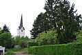
Saint Gallus Church

Mosque of the Turkish cultural association Olten with minaret

Co-op shop in the village center

Agrola gas station and Landi
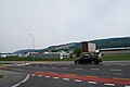
Industrial zone in the west of the municipality


coat of arms
- Split from red with white St. Gallus and von Weiss with a red bear standing upright, holding a trunk in their paws, the two figures facing each other
Gallus is the church patron of von Wangen.
Personalities
- Stephan Kauf (1907–1962), Benedictine and abbot of Muri-Gries
- Alfred Flury (1934–1986), Roman Catholic clergyman and songwriter ( New Spiritual Song )
Web links
- Official website of the municipality of Wangen bei Olten
- Hans Brunner: Wangen bei Olten. In: Historical Lexicon of Switzerland .
Individual evidence
- ↑ Permanent and non-permanent resident population by year, canton, district, municipality, population type and gender (permanent resident population). In: bfs. admin.ch . Federal Statistical Office (FSO), August 31, 2019, accessed on December 22, 2019 .
- ↑ nzz.ch: [1] , January 9, 2009.
- ↑ Possible break in the minaret dispute. Turkish cultural association Olten ready to wait. , NZZ Online, November 18, 2006.
- ↑ No permission for a minaret. Muslims want to appeal against the decision in Wangen at Olten. , NZZ Online, February 8, 2006.
- ↑ Minaret in Wangen may still be built ( memento of the original from September 27, 2007 in the Internet Archive ) Info: The archive link was automatically inserted and not yet checked. Please check the original and archive link according to the instructions and then remove this notice. , Reformed News , July 14, 2006.
Boningen |
Däniken |
Dulliken |
Eppenberg-Wöschnau |
Fulenbach |
Gretzenbach |
Gunzgen |
Hägendorf |
Kappel |
Olten |
Rickenbach |
Schönenwerd |
Starrkirch-Wil |
Walterswil |
Wangen near Olten
Former parishes: Grod
Canton of Solothurn | Districts of the Canton of Solothurn | Municipalities of the Canton of Solothurn