Born (mountain)
| Born | ||
|---|---|---|
|
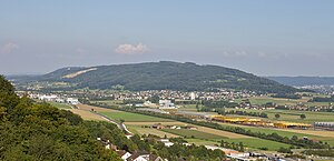
The Born, photographed by Egerkingen . In the center of the picture at the foot of the Born is Kappel . |
||
| height | 719 m above sea level M. | |
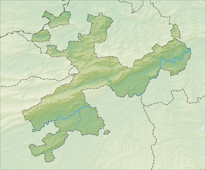
| location | Canton of Solothurn , Switzerland | |
| Mountains | law | |
| Dominance | 3.8 km → Hügert | |
| Notch height | 291 m ↓ basic mats | |
| Coordinates | 633 598 / 241387 | |
|
|
||
The Born is 719 m above sea level. M. high mountain in the Swiss canton of Solothurn southwest of the city of Olten . The summit is on the parish of Wangen near Olten and rises around 300 meters above the surrounding valley plains.
Location and surroundings
The Born is bounded in the south and east by the Aare , in the north by the wide Dünner valley and in the west by the gravel embankments in the Gäu . Towards the south the Born falls relatively steeply to the Aare, while the slopes towards the west and north have less inclinations. In the east, the ridge of the Born is separated from the hill of Engelberg by the Klus von Aarburg . The ridge is almost entirely covered by forest.
geology
From a geological point of view, the Born and Engelberg to the east form the southernmost anticline of the Jura in the Olten region. The rock material of the Born comes from marine sediments of the Upper Jurassic Period ( Malmkalk ), which are now exposed in the area of the Aarburg Klus. This clus in the Born anticline was originally formed by the Wigger in geological times and has only been traversed by the Aare since the Ice Age. The gravel deposits of the Glacier from the Ice Age had modeled the topography of the area in such a way that the Aare could not maintain its former course along the Jura through the Gäu (corresponding to today's lower reaches of the Dünnern) and therefore had to move further south into the Central Plateau and join the Wigger united to flow northwards through the gorge. The Chessiloch , a tectonic cave, is located in the wooded southern slope of the Born .
prehistory
Born on the flanks of the people won since the Stone Age flint ( silex ). Several settlement sites in the area of the municipalities of Olten, Wangen bei Olten and Boningen are proven.
Economic history
The woods on the Born are used by the mayors of Olten and Wangen bei Olten.
On the northern slope there is a large quarry in which the Portlandcementwerk Olten (PCO), with a concession from the Olten community, has been mining Jura limestone and marl since the first half of the 20th century and until 1996 .
The Ruppoldingen hydropower plant , built in 1896, was expanded by a pumped storage power plant around 1920 , the water storage of which on the Born plateau was fed via a pressure line through which the water flowed to the turbine in the power plant when there was a high demand for electricity in the network.
Attractions
On a plateau on the western slope of the Born is the Born Chapel , built around 1866 by the municipality of Kappel , which was designed by Wilhelm Keller .
From the Aare , between Aarburg and Ruppoldingen , the Tuusigerstägli (1000- meter staircase) leads up the mountain. The 1,150 steps are also used for fitness programs.
Web links
- Working Group for Speleology (AGS) - Chessiloch, 2006 PDF 156 kB
- Working Group for Speleology (AGS) - Chessiloch, 2003 PDF 411 kB
Individual evidence
- ↑ 1000er-Stägli on the website of the municipality of Aarburg, accessed on February 22, 2016


