
Boningen
| Boningen | |
|---|---|
 |
|
| State : |
|
| Canton : |
|
| District : | Olten |
| BFS no. : | 2571 |
| Postal code : | 4618 |
| Coordinates : | 631 738 / 239956 |
| Height : | 410 m above sea level M. |
| Height range : | 392–479 m above sea level M. |
| Area : | 2.76 km² |
| Residents: | 772 (December 31, 2018) |
| Population density : | 280 inhabitants per km² |
| Website: | www.boningen.ch |
 Boningen |
|
| Location of the municipality | |
  |
|
Boningen is a municipality in the Olten district in the canton of Solothurn in Switzerland . The community is located in the Solothurnian Gäu and has a rural structure with few farms. The construction of the motorway and the gravel pit with the various gravel processing industries have not changed that.
geography
The village is located at the southern foot of the Born ( 719 m above sea level ) on two steps above the left bank of the Aare . Of the 280 hectares of municipal area, 22.1% is settlement area, 40.6% is agricultural area, 30.6% is forest and woodland and 6.8% is unproductive areas.
population
On December 31, 2018, 772 people lived in Boningen, 9.5% of them foreigners. According to the 2000 census, the most widely spoken language, at 95.75%, is Swiss German , followed by Serbo-Croatian (1.75%) and Italian (0.63). On December 11, 2008, the 700th inhabitant was registered.
| Population development | |
|---|---|
| year | Residents |
| 1837 | 230 |
| 1850 | 281 |
| 1900 | 287 |
| 1950 | 376 |
| 2007 | 665 |
history
First mentioned in a document in 1225, the village belonged to the Fridaueramt in the Middle Ages . The name means among the members of the Bonno . Various monasteries and monasteries owned properties in Boningen at that time. The tithe of Boningen originally belonged to the Counts of Frohburg , then to the Counts of Nidau , later to the Barons of Falkenstein and then in 1454 came to the chaplain "Our Lady" in Olten . Until 1687 Boningen was parish after Hägendorf . After a church was built in Kappel , Kappel and Boningen formed their own parish . In the village itself there has been a simple chapel since 1744, which was restored at great expense in 1974. At the same time, the Bruderklauskirche was built, which fits in well with the village landscape next to the Spycher and the pond and the old schoolhouse built in 1837.
Political system
The village's executive is made up of a five-person municipal council , each of which heads a department. The legislative power is vested in the hands of the municipal assembly . This is properly convened twice a year and takes place in the multi-purpose hall of the village, the «Schnäggehalle». It consists of all residents with voting rights.
In addition the group consisting of all the inhabitants municipality there are the civic community , which all people belong to the civil rights have of Boningen. The civil parish is one of the largest landowners. In addition to a large part of the forest, she also owns various properties and building land, including the land on which the Boningen gravel works is located. In addition to rent and lease interest, this gravel extraction represents the largest source of income for the community.
education
Boningen has a kindergarten for five and six year old children as well as a primary school from the 1st to the 6th grade. After that, the pupils must in any case switch to the secondary schools in Olten.
economy
In addition to various SME companies and sole proprietorships , Boningen has a large gravel works. The new hydropower plant Neu Ruppoldingen owned by Alpiq Holding is also located in the municipality.
traffic
A well-developed post bus service connects Boningen with the Aaregäu from Fulenbach via Wolfwil to Oensingen and in the other direction with Aarburg and Olten .
Attractions

Mariahilf chapel and village warehouse

Mariahilf Chapel

church

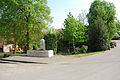
Tourist information
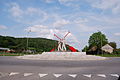
Roundabout
Pond in the village center

Multipurpose gym
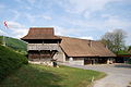
Village attic and farmhouse


coat of arms
- In white over a red rudder placed at an angle to the left, a slanting red spike
Web links
- Official website of the community of residents and citizens of Boningen
- Urs Wiesli: Boningen. In: Historical Lexicon of Switzerland .
Individual evidence
- ↑ Permanent and non-permanent resident population by year, canton, district, municipality, population type and gender (permanent resident population). In: bfs. admin.ch . Federal Statistical Office (FSO), August 31, 2019, accessed on December 22, 2019 .
Boningen |
Däniken |
Dulliken |
Eppenberg-Wöschnau |
Fulenbach |
Gretzenbach |
Gunzgen |
Hägendorf |
Kappel |
Olten |
Rickenbach |
Schönenwerd |
Starrkirch-Wil |
Walterswil |
Wangen near Olten
Former parishes: Grod
Canton of Solothurn | Districts of the Canton of Solothurn | Municipalities of the Canton of Solothurn