
Gunzgen
| Gunzgen | |
|---|---|
 |
|
| State : |
|
| Canton : |
|
| District : | Olten |
| BFS no. : | 2578 |
| Postal code : | 4617 |
| Coordinates : | 629529 / 240717 |
| Height : | 429 m above sea level M. |
| Height range : | 413-460 m above sea level M. |
| Area : | 3.93 km² |
| Residents: | 1652 (December 31, 2018) |
| Population density : | 420 inhabitants per km² |
| Website: | www.gunzgen.ch |
 Gunzgen Church |
|
| Location of the municipality | |
  |
|
Gunzgen is a municipality in the Olten district in the canton of Solothurn in Switzerland .
geography
Gunzgen is 429 m above sea level. M. , 7 km southwest of the district capital Olten (linear distance). The village extends in the thin plain near the southern foot of the Jura in the so-called Mittelgäu of the Solothurn Mittelland .
The area of the 3.9 km² municipal area comprises a section of the Aare valley in the Swiss plateau. The northern municipal boundary runs along the canalized Dünnern. From here the area extends as a narrow band southwards over the wide gravel plain with the corridors Lischmatten and Welschmatt (on average at 430 m above sea level ) to the forest heights Eichliban ( 450 m above sea level ) and Stierenban ( 452 m above sea level). M. ), which represent the westernmost foothills of the Born . The highest point of Gunzgen is 460 m above sea level. M. reached at Buholz at the west foot of the Born. Further to the south, the gravel terrace of the Gunzger Allmend joins the Forenban . In 1997, 23% of the municipal area was in settlements, 27% in forests and woodlands, 49% in agriculture and around 1% was unproductive land.
The Gunzger Allmend settlement ( 425 m above sea level ) on the gravel terrace south of the bull bar belongs to Gunzgen . The neighboring communities of Gunzgen are Hägendorf , Kappel , Boningen , Fulenbach , Härkingen and Egerkingen .
population
With 1652 inhabitants (as of December 31, 2018) Gunzgen is one of the medium-sized communities in the canton of Solothurn. 95.7% of the residents speak German, 1.0% speak Italian and 1.0% speak Turkish (as of 2000). Gunzgen had a population of 514 in 1850 and 418 in 1900. In the course of the 20th century, the population rose continuously to 786 people until 1970. Since then, there has been a significant increase in population combined with a doubling of the population within 30 years.
economy

Until well into the 20th century, Gunzgen was predominantly an agricultural community. Today arable farming , fruit growing and forestry have only a minor role in the employment structure of the population.
Numerous other jobs are available in trade and especially in the service sector. Due to the excellent transport links, various storage and distribution companies, logistics centers and the superstructure workshops of the Swiss Federal Railways (SBB) have settled in the area of Gunzgen since the 1970s . In addition, companies in the building and transport industry, metal construction, mechanical engineering and carpentry are represented in the community. There is a large gravel mining area in Gunzger Allmend. In the last few decades Gunzgen has also developed into a residential community. Many workers are therefore commuters who mainly work in the Olten region.
traffic
The community is very well developed in terms of transport. It is located on a connecting road from Wangen bei Olten to Kestenholz . The closest connection to the Swiss motorway network is around 3 km from the town center. The municipality is crossed by the A1 motorway ( Bern - Zurich ), which here is combined with the A2 ( Basel - Lucerne ). Because of its two motorway service stations (Gunzgen-Nord and Gunzgen-Süd), the village gained notoriety beyond the region.
The Gäubahn ( Olten –Solothurn) runs north of the village, although it has no train station near Gunzgen; the next train station is in Hägendorf. Gunzgen is connected to the public transport network by a BOGG bus line ( Busbetrieb Olten Gösgen Gäu ), which serves the route from Olten to Kestenholz.
history

The municipality of Gunzgen was settled very early, which was proven by the discovery of a burial mound from the Hallstatt period on the Stierenban. In 1226 the village was first mentioned as Gunzichon . Later the names Gunzkon (1320), Guntzgen (1367), Guntzikon (1415) and Guntzgon (1426) appeared. The place name goes back to the Old High German personal name Gunzo . With the name ending -gen (actually a contraction of -igkofen ) it means something like the farms of the Gunzo people, whereby so-called repatriate farms are meant.
Since the Middle Ages Gunzgen was part of the Buchsgau administered by the Counts of Frohburg and belonged to the Fridau rule . It shared their fate and in 1463 came under the sole administration of Solothurn, whereby it was assigned to the Lower Office of the Bechburg Bailiwick. After the collapse of the Ancien Régime (1798) Gunzgen belonged to the Solothurn administrative district during the Helvetic Republic and to the Olten district from 1803.
Between 1840 and 1880 the village lost almost a third of its inhabitants due to the economic hardship due to emigration and emigration overseas and at the end of the period had only 366 inhabitants. In 1893 both Gunzgen and the Gunzger Allmend settlement were affected by two fires. With the establishment of a metal goods factory in 1919, the industry also gained a foothold in Gunzgen.
Attractions
The St. Catherine Chapel was built in 1645. It underwent a redesign in 1860 when Gunzgen was raised to an independent parish. The church was given its present form in 1951 through renewed renovations and enlargements.
photos

Interior of the church
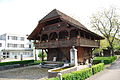
Old granary
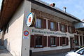
Restaurant Eintracht


coat of arms
- Divided by white with green oak with five leaves and six green fruits and by blue with a yellow St. Catherine wheel with eight spokes and eight knives
Web links
- Official website of the municipality of Gunzgen
- Urs Wiesli: Gunzgen. In: Historical Lexicon of Switzerland .
Individual evidence
- ↑ Permanent and non-permanent resident population by year, canton, district, municipality, population type and gender (permanent resident population). In: bfs. admin.ch . Federal Statistical Office (FSO), August 31, 2019, accessed on December 22, 2019 .
Boningen |
Däniken |
Dulliken |
Eppenberg-Wöschnau |
Fulenbach |
Gretzenbach |
Gunzgen |
Hägendorf |
Kappel |
Olten |
Rickenbach |
Schönenwerd |
Starrkirch-Wil |
Walterswil |
Wangen near Olten
Former parishes: Grod
Canton of Solothurn | Districts of the Canton of Solothurn | Municipalities of the Canton of Solothurn