
Tube SO
| SO is the abbreviation for the canton of Solothurn in Switzerland and is used to avoid confusion with other entries of the name Rohr . |
| pipe | |
|---|---|
 |
|
| State : |
|
| Canton : |
|
| District : | Gösgen |
| BFS no. : | 2498 |
| Postal code : | 4655 |
| Coordinates : | 639 014 / 251273 |
| Height : | 578 m above sea level M. |
| Height range : | 541–948 m above sea level M. |
| Area : | 2.23 km² |
| Residents: | 91 (December 31, 2018) |
| Population density : | 41 inhabitants per km² |
| Website: | www.rohr-so.ch |
 Rohr seen from the village entrance coming from Stüsslingen |
|
| Location of the municipality | |
  |
|
Rohr is a municipality in the district of Gösgen in the canton of Solothurn in Switzerland .
geography
Rohr lies at 578 m above sea level. M. , 8 km northeast of the city of Olten (linear distance). The small farming village extends into the Solothurn Jura , in a basin in the headwaters of the Stüsslinger Bach, at the southern foot of the pass crossing over the Schafmatt.
The area of the community area of 2.3 km² covers a section of the eastern Folded Jura , which here has a complicated geological structure and is divided into various sheds. The Rohr valley basin, in which the Stüsslinger Bach rises, is almost completely closed; only towards the south is there a connection with the Central Plateau through a narrow point between the Walmattberg (up to 910 m above sea level ) and the Stellirain ( 781 m above sea level ) . In the north the border runs more or less on the main ridge of the Jura, the watershed between the Aare in the south and the Ergolz in the north. The border mountains are the Leutschenberg ( 925 m above sea level ) and the Geissflue (above the Rohrerplatte , the highest point of Rohr is reached at 945 m above sea level ). In the east, the border lies on the Rosmaregg and the Rütflue ( 849 m above sea level ), which separate the Rohr basin from the Erzbachtal. In 1997, 6% of the municipal area was accounted for by settlements, 50% for forests and woodlands and 44% for agriculture.
Some individual farms belong to Rohr. Neighboring communities of Rohr are Erlinsbach , Stüsslingen and Lostorf in the canton of Solothurn and Zeglingen and Oltingen in the canton of Basel-Landschaft .
population
With 91 inhabitants (as of December 31, 2018), Rohr is one of the smallest communities in the canton of Solothurn. 96.4% of the residents speak German, 2.7% speak English and 0.9% speak Polish (as of 2000). The population of Rohr was 195 inhabitants in 1850, in 1900 it was 120 inhabitants. In the course of the 20th century, the population fluctuated between 100 and 125 people until 1970. After that, a population decrease to 84 inhabitants was recorded by 1980.
economy
Rohr still lives from agriculture , especially from dairy farming and cattle breeding . There is also some agriculture and fruit growing . There are very few jobs outside the primary sector. Smaller commercial and industrial zones have emerged mainly in the Schachen area. Some workers are also commuters who mainly work in the Olten and Aarau regions.
traffic
The community is far away from the larger thoroughfares on a connecting road from Stüsslingen over the Schafmatt Pass to Oltingen . The village is connected to the public transport network by a BOGG bus line ( Busbetrieb Olten Gösgen Gäu ), which operates the route from Olten to Rohr at certain times of the day .
history
The first written mention of the place took place in 1022 under the name Rore . The place name goes back to the Old High German word ror (reed, reed).
In the past, in contrast to today, the Schafmatt Pass was much more important as a Jura crossing between the Basel region and the Mittelland. A pilgrimage to Einsiedeln Abbey also led over the pass. Since the Middle Ages, Rohr has been under the rule of Gösgen, which Solothurn acquired in 1458 . The village was then assigned to the Bailiwick of Gösgen. After the collapse of the Ancien Régime (1798), Rohr belonged to the Solothurn administrative district during the Helvetic Republic and to the Gösgen district from 1803.
Attractions
The St. Ulrich chapel was probably donated by the Einsiedeln monastery in the 12th or 13th century. The chapel received its present shape when it was rebuilt in the 17th century. It contains a late Gothic statue of Our Lady and a crucifix from 1668.
photos
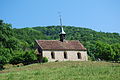
St. Ulrich pilgrim chapel
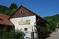
Farmhouse with painting of the chapel in the center of Rohr

Bus stop and signpost
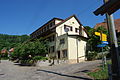
Residential house in the village center


coat of arms
- A black house sign in yellow on a green three-leaf clover, on the right side with a green three-leaf clover; Above left, a four-petalled red rose with a yellow clump and green sepals
Web links
- Official website of the municipality of Rohr
- Hans Brunner: Rohr SO. In: Historical Lexicon of Switzerland .
Individual evidence
- ↑ Permanent and non-permanent resident population by year, canton, district, municipality, population type and gender (permanent resident population). In: bfs. admin.ch . Federal Statistical Office (FSO), August 31, 2019, accessed on December 22, 2019 .
Erlinsbach (SO) |
Hauenstein-Ifenthal |
Kienberg |
Lostorf |
Niedergösgen |
Obergösgen |
Pipe |
Stüsslingen |
Trimbach |
Winznau |
Wisen
Former communities: Niedererlinsbach | Obererlinsbach
Canton of Solothurn | Districts of the Canton of Solothurn | Municipalities of the Canton of Solothurn