
Konolfingen district
| Konolfingen district | |
|---|---|
-coat_of_arms.svg) |
|
| Basic data | |
| Country: |
|
| Canton : |
|
| Main town : | Schlosswil |
| Area : | 213.55 km² |
| Residents: | 57,573 (December 31, 2008) |
| Population density : | 270 inhabitants per km² |
| map | |
 |
|
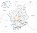
The Konolfingen district was an administrative unit of the Canton of Bern until December 31, 2009 . The administrative district with the main town Schlosswil , where the governor resided in Schloss Wil , comprised 30 communities on 213.55 km²:
Communities
| Name of the parish | Population (December 31, 2008) |
Area in km² | Inhabitants per km² |
|---|---|---|---|
| Aeschlen near Oberdiessbach | 301 | 4.90 | 61 |
| Allmendingen | 498 | 3.81 | 131 |
| Arni (BE) | 975 | 10.43 | 93 |
| Biglen | 1740 | 3.59 | 485 |
| Bleiken near Oberdiessbach | 377 | 3.40 | 111 |
| Bowil | 1381 | 14.69 | 94 |
| Brenzikofen | 555 | 2.19 | 253 |
| Open greases | 406 | 2.96 | 137 |
| Grosshöchstetten | 3168 | 3.47 | 913 |
| Skinned | 231 | 3.07 | 75 |
| Herbigen | 546 | 2.76 | 198 |
| Pebbles | 789 | 4.69 | 168 |
| Konolfingen | 4739 | 12.77 | 371 |
| Landiswil | 641 | 10.26 | 62 |
| Linden trees | 1326 | 13.23 | 100 |
| Mirchel | 536 | 2.34 | 229 |
| Münsingen | 11,023 | 8.50 | 1297 |
| Prostrate | 647 | 5.42 | 119 |
| Oberdiessbach | 2880 | 8.20 | 351 |
| Oberhünigen | 344 | 6.01 | 57 |
| Oberthal | 804 | 10.54 | 76 |
| Oppligen | 641 | 3.40 | 189 |
| Rubigen | 2746 | 6.92 | 397 |
| Schlosswil | 651 | 3.46 | 188 |
| Tagertschi | 389 | 3.62 | 107 |
| Trim stone | 480 | 3.62 | 133 |
| Walk wrestling | 1822 | 17.21 | 106 |
| Wichtrach | 4012 | 11.60 | 346 |
| Worb | 11,359 | 21.08 | 539 |
| Zziwil | 1566 | 5.41 | 289 |
| Total (30) | 57,573 | 213.55 | 270 |
Changes in the community

Parishes until 1869

Municipalities until 1887

Municipalities until 1901
Municipalities until 1932

Municipalities until 1945

Municipalities until 1979

Municipalities until 1982

Municipalities until 1992

Municipalities until 2003

Municipalities until 2009


- 1870: Name change from Diessbach → Oberdiessbach
- 1888: Merger of Ausserbirrmoos , Perschwand and Schönthal → Ausserbirrmoos
- 1888: Merger of Hauben and Oberdiessbach → Oberdiessbach
- 1902: Name change from Höchstetten → Grosshöchstetten
- 1902: Name change from Wil (BE) → Schlosswil
- 1933: Gysenstein and Stalden merge in the Emmental → Konolfingen
- 1946: Merger of Ausserbirrmoos , Innerbirrmoos and Otterbach → Linden
- 1980: Split from Schlosswil → Oberhünigen
- 1983: Name change from Arni → Arni (BE)
- 1993: Spin-off from Rubigen → Allmendingen near Bern and Trimstein
- 2004: Merger of Niederwichtrach and Oberwichtrach → Wichtrach
- 2010: Aeschlen near Oberdiessbach and Oberdiessbach → Oberdiessbach
- 2010: District change of all 30 municipalities from the Konolfingen district → Bern-Mittelland administrative district
literature
- Ernst Werder: The legal sources of the Canton of Bern, Part Two: Rights of the Landscape, Volume 4: The Law of the Konolfingen Regional Court (= Swiss Lawyers Association. Legal Sources Foundation [Ed.]: Collection of Swiss Legal Sources . II. Department). Sauerländer, Aarau 1950, DNB 453942210 ( online ).
Web links
Individual evidence
Aarberg | Aarwangen | Bern | Biel | Büren | Burgdorf | Courtelary | Erlach | Fraubrunnen | Frutigen | Interlaken | Konolfingen | Laupen | Moutier | La Neuveville | Nidau | Lower Simmental | Oberhasli | Obersimmental | Saanen | Schwarzenburg | Juicy | Signau | Tuna | Trachselwald | Cheeks
Canton of Bern | Districts of Switzerland | Municipalities of the Canton of Bern

Four parishes: Bolligen | Vechigen | Stettlen | Muri
Regional courts: Seftigen | Sternenberg | Konolfingen | Zollikofen
Offices: Thun | Zofingen | Aarau | Lenzburg | Brugg | Burgdorf | Büren | Unterseen | Wiedlisbach | Obersimmental | Lower Simmental | Frutigen | Oberhofen | Aigle | Hasli | Trachselwald | Bipp | Aarwangen | Cheeks | Landshut | Lenzburg (Office) | Schenkenberg | Aarberg | Nidau | Erlach | Laupen | Oltigen | Signau | Biberstein | Aarburg | Saanen | Brandis | Interlaken | Königsfelden | Thorberg | Fraubrunnen | Zofingen (pen) | Frienisberg | St. Johannsen | Gottstatt | Buchsee | Sumiswald | Roche (Saline) | Köniz | Kasteln | Hettiswil
Offices in Vaud: Avenches | Moudon | Yverdon | Lausanne | Morges | Nyon | Vevey | Romainmôtier | Oron | Payerne | Bonmont | Aubonne
Common lords with Freiburg: Schwarzenburg | Murten | Grandson | Echallens
Common federal dominions: Baden | Thurgau | Free offices | Rhine Valley | Sargans | Locarno | Lugano | Mendrisio | Valle Maggia
Offices and services in the city of Bern: Bauamt | Salt Directorate | Mushafen | Pen | Corn Office | Big hospital | Inselspital