
Interlaken district
| Interlaken district | |
|---|---|
 |
|
| Basic data | |
| Country: |
|
| Canton : |
|
| Main town : | Interlaken |
| Area : | 677.92 km² |
| Residents: | 38,386 (December 31, 2008) |
| Population density : | 57 inhabitants per km² |
| map | |
 |
|
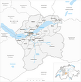
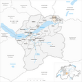
The Interlaken district was an administrative unit of the Canton of Bern until December 31, 2009 . The administrative district with the main town Interlaken comprised 23 communities on 677.92 km²:
Communities
| Name of the parish | Population (December 31, 2008) |
Area in km² | Inhabitants per km² |
|---|---|---|---|
| Beatenberg | 1153 | 29.17 | 40 |
| Bönigen | 2383 | 15.10 | 158 |
| Brienz (BE) | 2996 | 48.06 | 62 |
| Brienzwiler | 533 | 17.64 | 30th |
| Därligen | 401 | 6.93 | 58 |
| Grindelwald | 3826 | 171.33 | 22nd |
| Gsteigwiler | 425 | 7.02 | 61 |
| Gündlischwand | 282 | 16.84 | 17th |
| Habkern | 624 | 51.03 | 12 |
| Hofstetten near Brienz | 579 | 8.77 | 66 |
| Interlaken | 5319 | 4.27 | 1246 |
| Iseltwald | 397 | 21.91 | 18th |
| Lauterbrunnen | 2452 | 164.51 | 15th |
| Leissigen | 938 | 10.38 | 90 |
| Lütschental | 238 | 12.28 | 19th |
| Mats at Interlaken | 3676 | 5.91 | 622 |
| Niederried near Interlaken | 335 | 4.28 | 78 |
| Oberried on Lake Brienz | 492 | 20.14 | 24 |
| Ringgenberg (BE) | 2709 | 8.73 | 310 |
| Saxeten | 103 | 19.38 | 5 |
| Schwanden near Brienz | 614 | 7.06 | 87 |
| Unterseen | 5453 | 13.99 | 390 |
| Wilderswil | 2458 | 13.19 | 186 |
| Total (23) | 38,386 | 677.92 | 57 |
Changes in the community
Municipalities until 1890
Municipalities until 1910

Municipalities until 1913

Municipalities until 1972

Municipalities until 2009


- 1853: Merger of Goldswil and Ringgenberg → Ringgenberg
- 1891: Name change from Aarmühle → Interlaken
- 1911: Change of name from Schwanden → Schwanden near Brienz
- 1914: Ebligen and Oberried am Brienzersee merge → Oberried am Brienzersee
- 1973: Merger of Isenfluh , Lauterbrunnen , Mürren and Wengen → Lauterbrunnen
- 2010: District change of all 23 municipalities from the Interlaken district → Interlaken-Oberhasli administrative district
Web links
- Barbara Studer: Interlaken (monastery, administrative district). In: Historical Lexicon of Switzerland .
Individual evidence
Aarberg | Aarwangen | Bern | Biel | Büren | Burgdorf | Courtelary | Erlach | Fraubrunnen | Frutigen | Interlaken | Konolfingen | Laupen | Moutier | La Neuveville | Nidau | Lower Simmental | Oberhasli | Obersimmental | Saanen | Schwarzenburg | Juicy | Signau | Tuna | Trachselwald | Cheeks
Canton of Bern | Districts of Switzerland | Municipalities of the Canton of Bern

Four parishes: Bolligen | Vechigen | Stettlen | Muri
Regional courts: Seftigen | Sternenberg | Konolfingen | Zollikofen
Offices: Thun | Zofingen | Aarau | Lenzburg | Brugg | Burgdorf | Büren | Unterseen | Wiedlisbach | Obersimmental | Lower Simmental | Frutigen | Oberhofen | Aigle | Hasli | Trachselwald | Bipp | Aarwangen | Cheeks | Landshut | Lenzburg (Office) | Schenkenberg | Aarberg | Nidau | Erlach | Laupen | Oltigen | Signau | Biberstein | Aarburg | Saanen | Brandis | Interlaken | Königsfelden | Thorberg | Fraubrunnen | Zofingen (pen) | Frienisberg | St. Johannsen | Gottstatt | Buchsee | Sumiswald | Roche (Saline) | Köniz | Kasteln | Hettiswil
Offices in Vaud: Avenches | Moudon | Yverdon | Lausanne | Morges | Nyon | Vevey | Romainmôtier | Oron | Payerne | Bonmont | Aubonne
Common lords with Freiburg: Schwarzenburg | Murten | Grandson | Echallens
Common federal dominions: Baden | Thurgau | Free offices | Rhine Valley | Sargans | Locarno | Lugano | Mendrisio | Valle Maggia
Offices and services in the city of Bern: Bauamt | Salt Directorate | Mushafen | Pen | Corn Office | Big hospital | Inselspital