
Brugg district
| Brugg district | |
|---|---|
 |
|
| Basic data | |
| Country: |
|
| Canton : |
|
| Main town : | Brugg |
| FSO number : | 1904 |
| Area : | 145.11 km² |
| Height range : | 325–800 m above sea level M. |
| Residents: | 51,416 (December 31, 2019) |
| Population density : | 354 inhabitants per km² |
| map | |
 |
|

| Seats in the Grand Council (2016-2020) |
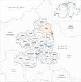
The Brugg district is a district in the canton of Aargau in Switzerland . It comprises 23 municipalities and is made up of the former offices of Bözberg , Schenkenberg and Eigenamt , which essentially comprises the areas on both sides of the Bözberg, the Geissberg and the Birrfeld between Aare and Reuss . Thus, the part north of the Aare is in the Aargau Jura , while the southern part is part of the Swiss Plateau.
On January 1, 2010, the municipality of Hottwil merged with four municipalities in the Laufenburg district to form the municipality of Mettauertal . The new community is located in the Laufenburg district, including the ban on Hottwil, which means that the Brugg district has lost its area around it.
Municipalities
| coat of arms | Name of the parish | Population (December 31, 2019) |
Area in km² |
Inhabitant per km² |
|---|---|---|---|---|
|
|
Auenstein | 1606 | 5.68 | 283 |
|
|
Birr | 4587 | 5.05 | 908 |
|
|
Birrhard | 759 | 3.00 | 253 |
|
|
Bozberg | 1645 | 15.50 | 106 |
|
|
Bözen | 803 | 3.96 | 203 |
|
|
Brugg | 12,554 | 8.26 | 1520 |
|
|
Effingen | 620 | 6.85 | 91 |
|
|
Elfingen | 295 | 4.22 | 70 |
|
|
Habsburg | 423 | 2.23 | 190 |
|
|
Hausen (AG) | 3646 | 3.20 | 1139 |
|
|
Lupfig | 3141 | 8.45 | 372 |
|
|
Mandach | 334 | 5.54 | 60 |
|
|
Mönthal | 395 | 3.94 | 100 |
|
|
Garbage | 1083 | 3.16 | 343 |
|
|
Remigen | 1227 | 7.87 | 156 |
|
|
Riniken | 1458 | 4.76 | 306 |
|
|
Rüfenach | 840 | 4.17 | 201 |
|
|
Schinznach | 2262 | 12.24 | 185 |
|
|
Thalheim (AG) | 812 | 9.92 | 82 |
|
|
Veltheim (AG) | 1519 | 5.24 | 290 |
|
|
Villigen | 2145 | 11.21 | 191 |
|
|
Villnachern | 1655 | 5.75 | 288 |
|
|
Windisch | 7607 | 4.91 | 1549 |
| Total (23) | 51'416 | 145.11 | 354 | |
As of January 1, 2020
Changes in the community

Municipalities until 1872

Municipalities until 1897

Municipalities until 1900

Municipalities until 1937

Parishes until 1969

Municipalities until 2002
Municipalities until 2005

Municipalities until 2009

Municipalities until 2012

Municipalities until 2013

Municipalities until 2017

Municipalities by 2019


- 1803: Separation of Hof Rein → Lauffohr , Rein , Rüfenach and parts of Remigen
- 1873: Split from Bözberg → Oberbözberg and Unterbözberg
- 1898: Merger of Rein and Rüfenach → Rüfenach
- 1901: Altenburg and Brugg → Brugg merge
- 1938: Name change from Birrenlauf → Schinznach-Bad
- 1938: Name change from Schinznach → Schinznach-Dorf
- 1970: Merger of Brugg and Lauffohr → Brugg
- 2003: Name change from Hausen bei Brugg → Hausen (AG)
- 2003: Name change from Schinznach Bad → Schinznach-Bad
- 2003: Name change from Schinznach Dorf → Schinznach-Dorf
- 2006: Merger of Villigen and Stilli → Villigen
- 2010: Brugg and Umiken → Brugg merged
- 2010: Merger of Hottwil , Etzgen , Mettau , Oberhofen and Wil → Mettauertal (the area of the dissolved municipality of Hottwil has since been in the Laufenburg district)
- 2013: Fusion of Gallenkirch , Linn , Oberbözberg and Unterbözberg → Bözberg
- 2014: Merger of Oberflachs and Schinznach-Dorf → Schinznach
- 2018: Fusion of Lupfig and Scherz → Lupfig
- 2020: Brugg and Schinznach Bad → Brugg merger
Localities
| Postcode | Name of the place | local community |
|---|---|---|
| Drive | Auenstein | |
| Altstalden | Bozberg | |
| Egenwil | Bozberg | |
| 5224 | Gallenkirch | Bozberg |
| Kirchbözberg | Bozberg | |
| 5224 | Linn | Bozberg |
| Neustalden | Bozberg | |
| 5225 | Oberbözberg | Bozberg |
| Uberhal | Bozberg | |
| 5224 | Untersözberg | Bozberg |
| origin | Bozberg | |
| Vierlinden | Bozberg | |
| 5200 | Altenburg | Brugg |
| Auhof | Brugg | |
| 5200 | Lauffohr | Brugg |
| 5222 | Umiken | Brugg |
| Chästel | Effingen | |
| 5246 | hoax | Lupfig |
| Dock | Mönthal | |
| Trot | Garbage | |
| Tiefgrueb | Riniken | |
| 5235 | Back clean | Rüfenach |
| 5235 | Front clean | Rüfenach |
| 5108 | Upper flax | Schinznach |
| 5107 | Schinznach village | Schinznach |
| Egghof | Thalheim | |
| Kilholz | Thalheim | |
| 5112 | Rattling | Thalheim |
| Schenkenberg | Thalheim | |
| 5233 | Stilli | Villigen |
| Oberburg | Windisch | |
| Oberdorf | Windisch | |
| Unterwindisch | Windisch |
Web links
Individual evidence
- ↑ Cantonal population statistics 2019. Department of Finance and Resources, Statistics Aargau, March 30, 2020, accessed on April 2, 2019 .
- ↑ Results of the Grand Council elections 2016. State Chancellery of the Canton of Aargau, accessed on July 27, 2020 .
- ↑ Federal Statistical Office Generalized Limits 2020.

Four parishes: Bolligen | Vechigen | Stettlen | Muri
Regional courts: Seftigen | Sternenberg | Konolfingen | Zollikofen
Offices: Thun | Zofingen | Aarau | Lenzburg | Brugg | Burgdorf | Büren | Unterseen | Wiedlisbach | Obersimmental | Lower Simmental | Frutigen | Oberhofen | Aigle | Hasli | Trachselwald | Bipp | Aarwangen | Cheeks | Landshut | Lenzburg (Office) | Schenkenberg | Aarberg | Nidau | Erlach | Laupen | Oltigen | Signau | Biberstein | Aarburg | Saanen | Brandis | Interlaken | Königsfelden | Thorberg | Fraubrunnen | Zofingen (pen) | Frienisberg | St. Johannsen | Gottstatt | Buchsee | Sumiswald | Roche (Saline) | Köniz | Kasteln | Hettiswil
Offices in Vaud: Avenches | Moudon | Yverdon | Lausanne | Morges | Nyon | Vevey | Romainmôtier | Oron | Payerne | Bonmont | Aubonne
Common lords with Freiburg: Schwarzenburg | Murten | Grandson | Echallens
Common federal dominions: Baden | Thurgau | Free offices | Rhine Valley | Sargans | Locarno | Lugano | Mendrisio | Valle Maggia
Offices and services in the city of Bern: Bauamt | Salt Directorate | Mushafen | Pen | Corn Office | Big hospital | Inselspital