
Lauffohr
| Lauffohr | ||
|---|---|---|
 |
||
| State : |
|
|
| Canton : |
|
|
| District : | Brugg | |
| Residential municipality : | Brugg | |
| Postal code : | 5200 | |
| former BFS no. : | 4102 | |
| Coordinates : | 659 729 / 261500 | |
| Height : | 336 m above sea level M. | |
| Residents: | 1500 (2005) | |
|
Proportion of foreigners : (residents without citizenship ) |
unknown | |
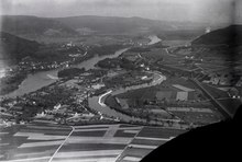
 Terrace settlement in Lauffohr |
||
| map | ||
|
||

Lauffohr is a village in the Swiss canton of Aargau . Until 1970 Lauffohr was an independent political municipality in the Brugg district and has belonged to Brugg ever since .
geography
.
Switzerland's moated castle is located on the former eastern municipal boundary . This is where three of the country's most important rivers flow together: First the Reuss flows into the Aare , and one and a half kilometers further north the Limmat . The old core of the street village is located in the narrow point between the 522 meter high Reinerberg and the mouth of the Limmat. Towards the southwest, a narrow, densely populated settlement zone extends at the foot of the Bruggerberg , which seamlessly merges into the development of Brugg. To the south of this is the agricultural Aufeld plain.
history
"Lufar" was first mentioned in a document in 1281. The village was part of the Rein farm , which belonged to the Murbach monastery in Alsace (the term farm was used to refer to the manorial rule over a larger area). In the 13th century, the Habsburgs summarized their sovereign rights in the area around Brugg in the Bözberg court. In addition to Lauffohr, this also included the villages of Oberbözberg , Unterbözberg , Linn , Mönthal , Remigen , Riniken , Rüfenach (with Rein) and Stilli . The Habsburgs exercised blood jurisdiction in all these places . King Rudolf I bought the Rein Hof in 1291 and was not only the chief judge, but also the most important landlord. In 1345 Queen Agnes of Hungary donated the farm to the Wittichen monastery in the Kinzig valley .

The name of the village came from a ferry across the Aare . Around 1410, however, this was relocated to Stilli further downstream. When the city of Bern conquered the area west of the Aare in 1460 , nothing changed in terms of the rights of the Wittichen monastery. The Catholic nuns, however, had to accept the introduction of the Reformation in 1528 . In 1544 the monastery sold the Rein farm to Count Hartmann von Hallwyl . In 1566, the Bernese dissolved the Bözberg court and court cases from that point on were heard in Stilli. Between 1588 and 1599 the city of Brugg acquired two thirds of the farm and Bern the remaining third.
In March 1798 the French took Switzerland, ousted the «Gracious Lords» of Bern and proclaimed the Helvetic Republic . The Rein farm came to the new canton of Aargau. In 1799 the front line ran through the middle of the lower Aare valley during the Second Coalition War . There were several French army camps in the region. The villagers suffered great hardship through requisitions and looting. In 1803 the canton dissolved the Rein farm; Lauffohr formed a community together with Rüfenach and Rein until 1809 and then gained independence.
The new community was in financial difficulties and therefore sold around a quarter of its territory to the city of Brugg in 1823; the purchase price was 1669 francs. From 1836 there was again a ferry: It served the workers in the factories of Vogelsang (municipality of Gibstorf ) and Turgi . It was in operation until the opening of the Aare bridge to Vogelsang in 1919. In the 19th century, the industry found its way into Lauffohr, so a cigar factory was established in 1852 , which existed until 1922. From 1890 the population began to increase continuously.

At the beginning of the 1960s, two thirds of the population lived in the rapidly growing part of the village of Au, which bordered directly on Brugg and at that time was clearly separated from the old village center by a large, unbuilt area. The residents of the Au felt drawn to Brugg and strove for a community merger. In the September 1964 vote, 97 voters were for and 64 against the merger. The enthusiasm of the Bruggers was limited; 494 yes were compared to 409 no. This rather tight result and the then very strong weighting of community autonomy prompted the Grand Council not to confirm the result. In the Lauffohr municipal council elections in August 1965, all seats went to merger advocates, which is why the topic remained topical. In April 1969 there was another vote: In Brugg the result was 1,095 yes to 397 no, in Lauffohr 113 yes to 100 no. In the meantime, the cantonal parliament had changed its stance on municipal mergers and confirmed the result. The merger finally took place on January 1, 1970.
coat of arms
| Population development | |
|---|---|
| year | Residents |
| 1764 | 109 |
| 1850 | 248 |
| 1900 | 293 |
| 1930 | 517 |
| 1950 | 596 |
| 1960 | 674 |
| 1970 | about 900 |
Since the merger, the municipal coat of arms has only had an informal character. The three rivers in a green field symbolize the confluence of the Aare , Reuss and Limmat .
traffic
Lauffohr is on main road 5 , which runs from Brugg in the direction of Waldshut . From Brugg train station , three post bus lines lead via Lauffohr to Döttingen , Mönthal and Bad Zurzach .
Attractions
Personalities
- Gustav Adolf Haggenmacher (1845–1875), Africa explorer
literature
- Michael Stettler , Emil Maurer : The art monuments of the Canton of Aargau, Volume II: The districts of Brugg, Lenzburg. (= Art Monuments of Switzerland. Volume 29). Edited by the Society for Swiss Art History GSK. Bern 1953. DNB 750561750 .
Web links
- Felix Müller: Lauffohr. In: Historical Lexicon of Switzerland .
Auenstein | Birr | Birrhard | Brugg | Bözberg | Bözen | Effingen | Elfingen | Habsburg | Hausen | Lupfig | Mandach | Mönthal | Garbage | Remigen | Riniken | Rüfenach | Schinznach | Thalheim | Veltheim | Villigen | Villnachern | Windisch
Former communities:
Altenburg |
Gallenkirch |
Hottwil |
Lauffohr |
Linn |
Oberbözberg |
Upper flax |
Pure |
Joke |
Schinznach-Bad |
Schinznach village |
Stilli |
Umiken |
Untersözberg
Canton of Aargau | Districts of the Canton of Aargau | Municipalities in the Canton of Aargau