
Mandach
| Mandach | |
|---|---|
 |
|
| State : |
|
| Canton : |
|
| District : | Brugg |
| BFS no. : | 4105 |
| Postal code : | 5318 |
| Coordinates : | 656256 / 266500 |
| Height : | 489 m above sea level M. |
| Height range : | 406–639 m above sea level M. |
| Area : | 5.54 km² |
| Residents: | 334 (December 31, 2019) |
| Population density : | 60 inhabitants per km² |
|
Proportion of foreigners : (residents without citizenship ) |
6.3% (December 31, 2019) |
| Website: | www.mandach.ch |
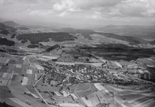
 Looking north to Mandach, in the background the Black Forest can be seen |
|
| Location of the municipality | |
  |
|
Mandach ( Swiss German : ˈmɑndəχ ) is a municipality in the Swiss canton of Aargau . It belongs to the Brugg district and is located about seven kilometers north of the district capital, near the border with Germany .
geography
The village is located in the middle of the Tafeljura between the Aare valley and the Rhine valley . It is surrounded by hills on all sides and is at the top of a valley that drains towards the north towards the Aare. In the west is the 605 meter high Wessenberg with the castle ruins of the same name , in the southwest the Besseberg ( 618 m above sea level ), in the south the Rotberg ( 638 m above sea level ) and in the east the foothills of the Bötteberg. In front of the Rotberg is the Hirzigen ( 538 m above sea level ). The village itself nestles against a 561-meter-high hill, which is simply called "mountain".
The area of the municipality is 554 hectares, of which 149 hectares are forested and 33 hectares are built over. The highest point is the ridge of the Rotberg at 638 meters, the lowest is at 430 meters on the northern municipal boundary. Neighboring communities are Leuggern in the north, Böttstein in the east, Villigen in the south and Mettauertal in the west.
history
Investigations around the Mandach Church suggest that the first church building was built on the foundations of a Roman estate. But the area was already around 500 BC. Was settled by the Celtic tribe of the Helvetii . In 1930, the remains of a Roman watchtower were found that had been built after the Alemanni raids from 259 to 270. The first written mention of Mandacho took place in 1218. The place name comes from the late Latin (praedium) Manduccacum and means estate belonging to the Manduccus.
In the Middle Ages, most of the land belonged to the Lords of Wessenberg , whose castle was on the mountain of the same name on the border with Hottwil . The rulers were the Habsburgs , who assigned the village to the Waldshut office. In 1316 the Habsburgs had to pledge the villages of Mandach and Hottwil to the Wessenbergers due to lack of money. These acquired the lower jurisdiction and blood jurisdiction , whereby they created a small, almost completely sovereign territory. In 1330, a “Her Hainrich von Mandach” was named as a witness in a document from the Zurzach Abbey , and in 1373 a servant Rudiger von Mandach.
In the Waldshut War of 1468, Bern occupied the dominion of Wessenberg and added it to its subject areas in the Bernese Aargau . Mandach was now part of the judicial district of Wessenberg in the office of Schenkenberg . The Bernese let the castle fall into disrepair, and in 1528 they introduced the Reformation . In 1518 a major fire destroyed the village, in 1593 and 1668 there were plague epidemics . The Mandach castle once stood on the banks of the Upper Rhine in Zurzach, in the southern Black Forest is still the ruins of the castle Mandach .
In March 1798 the French took Switzerland, ousted the «Gracious Lords» of Bern and proclaimed the Helvetic Republic . Since then, the community has belonged to the canton of Aargau. Due to its peripheral location, Mandach has remained a village characterized by agriculture and viticulture to this day. Between 1900 and 1970, the population fell by over 30 percent as many villagers were forced to look for work elsewhere. Since then, however, the population has increased slightly again.
Attractions

Before 1207, the Lords of Wessenberg had their ancestral seat built on the hill of the same name. The castle Wessenberg was about 9 meters wide and 40 meters long and fell into disuse after the conquest by the Bernese in 1468 into ruin. The Mandach Reformed Church originally dates from the 11th century. It contains frescoes from the 16th century, which were only rediscovered in 1962 during renovation work.
The oldest surviving community coffin comes from Mandach with the dendro date 1548; it is now in the Aargau Museum .
coat of arms

The blazon of the municipal coat of arms reads: "Divided by white with black moor growing out of the division with red lips and white necklace and by red." The municipal coat of arms corresponds to the coat of arms of the ministerial family of the nobles of Mandach and first appeared on the Zurich coat of arms around 1340 . The moor is said to represent Saint Mauritius .
population
The population developed as follows:
| year | 1850 | 1900 | 1930 | 1950 | 1960 | 1970 | 1980 | 1990 | 2000 | 2010 |
| Residents | 504 | 361 | 300 | 292 | 294 | 251 | 275 | 303 | 313 | 303 |
On December 31, 2019, 334 people lived in Mandach, 6.3% of them foreigners. In the 2015 census, 62.8% described themselves as Reformed and 18.0% as Roman Catholic ; 19.2% were non-denominational or of other faiths. 98.4% said German as their main language in the 2000 census .
Politics and law
The assembly of those entitled to vote, the municipal assembly , exercises legislative power. The executing authority is the five-member municipal council . He is elected by the people in the majority procedure, his term of office is four years. The parish council leads and represents the parish. To this end, it implements the resolutions of the municipal assembly and the tasks assigned to it by the canton. The Brugg District Court is the first instance responsible for legal disputes . Mandach belongs to the Friedensrichterkreis VIII (Brugg).
economy
According to the company structure statistics (STATENT) collected in 2015, there are around 80 jobs in Mandach, 55% of them in agriculture, 7% in industry and 38% in the service sector. Many workers are commuters and work in the Brugg region or in the larger communities in the area.
On the southern slopes of Besseberg, Berg and Hirzigen there are vineyards with an area of around 1.5 hectares. Mainly the varieties Riesling × Sylvaner and Blauburgunder are grown .
traffic
The village is located off the main thoroughfares, the main access is from Leuggern via Kantonsstrasse 445. Other secondary roads lead to Hottwil and over the Rotberg to Villigen . Mandach is connected to Leuggern and Döttingen train station by a post bus line.
education
Mandach has a school building with a kindergarten and primary school . The Realschule and the secondary school can be attended in Kleindöttingen or Leibstadt , the district school in Leuggern . The grammar schools are the Baden Cantonal School and the Wettingen Cantonal School .
Culture
In 2009, Mandach was the setting for the filming of the film Der Bad Unkel by Urs Odermatt .
literature
- Christoph Herzig: Mandach. In: Historical Lexicon of Switzerland .
- Michael Stettler , Emil Maurer : The art monuments of the canton of Aargau . Ed .: Society for Swiss Art History . Volume II: The districts of Lenzburg and Brugg. Birkhäuser Verlag, Basel 1953, DNB 750561750 .
Web links
Individual evidence
- ↑ Cantonal population statistics 2019. Department of Finance and Resources, Statistics Aargau, March 30, 2020, accessed on April 2, 2019 .
- ↑ Cantonal population statistics 2019. Department of Finance and Resources, Statistics Aargau, March 30, 2020, accessed on April 2, 2019 .
- ↑ a b Beat Zehnder: The community names of the canton of Aargau . In: Historical Society of the Canton of Aargau (Ed.): Argovia . tape 100 . Verlag Sauerländer, Aarau 1991, ISBN 3-7941-3122-3 , p. 73-74 .
- ^ National map of Switzerland, sheets 1050 and 1070, Swisstopo.
- ↑ Standard area statistics - municipalities according to 4 main areas. Federal Statistical Office , November 26, 2018, accessed on June 8, 2019 .
- ^ Martin Hartmann, Hans Weber: The Romans in Aargau . Verlag Sauerländer, Aarau 1985, ISBN 3-7941-2539-8 , p. 182 .
- ↑ Johannes Huber: The documents of the Zurzach Monastery, p. 292 and p. 295
- ↑ Stefan Hess : The so-called plague coffin of Mandach - an informative testimony to early modern sepulchral culture. In: Argovia 125 (2013), pp. 124-133
- ^ Joseph Galliker, Marcel Giger: Municipal coat of arms of the Canton of Aargau . Lehrmittelverlag des Kantons Aargau, book 2004, ISBN 3-906738-07-8 , p. 208 .
- ↑ Population development in the municipalities of the Canton of Aargau since 1850. (Excel) In: Eidg. Volkszählung 2000. Statistics Aargau, 2001, archived from the original on October 8, 2018 ; accessed on June 8, 2019 .
- ↑ Resident population by religious affiliation, 2015. (Excel) In: Population and Households, Community Tables 2015. Statistics Aargau, accessed on June 8, 2019 .
- ↑ Swiss Federal Census 2000: Economic resident population by main language as well as by districts and municipalities. (Excel) Statistics Aargau, archived from the original on August 10, 2018 ; accessed on June 8, 2019 .
- ↑ circles of justice of the peace. Canton of Aargau, accessed on June 18, 2019 .
- ↑ Statistics of the corporate structure (STATENT). (Excel, 157 kB) Statistics Aargau, 2016, accessed on June 8, 2019 .
- ↑ Grape harvest control 2018 Canton Aargau. (PDF, 2.4 MB) Agricultural Center Liebegg, 2019, accessed on June 18, 2019 .
- ↑ Carolin Frei: "The bad uncle" is set in and around Baden. Aargauer Zeitung , May 6, 2009, accessed June 8, 2019 .
Auenstein | Birr | Birrhard | Brugg | Bözberg | Bözen | Effingen | Elfingen | Habsburg | Hausen | Lupfig | Mandach | Mönthal | Garbage | Remigen | Riniken | Rüfenach | Schinznach | Thalheim | Veltheim | Villigen | Villnachern | Windisch
Former communities:
Altenburg |
Gallenkirch |
Hottwil |
Lauffohr |
Linn |
Oberbözberg |
Upper flax |
Pure |
Joke |
Schinznach-Bad |
Schinznach village |
Stilli |
Umiken |
Untersözberg
Canton of Aargau | Districts of the Canton of Aargau | Municipalities in the Canton of Aargau