
Habsburg AG
| AG is the abbreviation for the canton of Aargau in Switzerland and is used to avoid confusion with other entries of the name Habsburg . |
| Habsburg | |
|---|---|
 |
|
| State : |
|
| Canton : |
|
| District : | Brugg |
| BFS no. : | 4099 |
| Postal code : | 5245 |
| Coordinates : | 656367 / 257068 |
| Height : | 463 m above sea level M. |
| Height range : | 370-510 m above sea level M. |
| Area : | 2.23 km² |
| Residents: | 423 (December 31, 2019) |
| Population density : | 190 inhabitants per km² |
|
Proportion of foreigners : (residents without citizenship ) |
10.6% (December 31, 2019) |
| Website: | www.habsburg.ch |
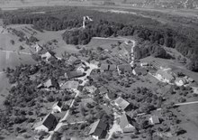
 The community of Habsburg with the castle of the same name |
|
| Location of the municipality | |
  |
|
Habsburg ( Swiss German : ˈhɑpsbrg ) is a municipality in the Swiss canton of Aargau . It belongs to the Brugg district and is located about three kilometers southwest of the district capital. The municipal area is the Habsburg , the ancestral home of the Habsburgs .
geography
The clustered village of Habsburg is located immediately east of the Wülpelsberg, on which the castle is located. The Wülpelsberg drops steeply into the Aare valley in the north and west . The east and south sides, on the other hand, form the edge of a slightly inclined plateau that merges seamlessly into the Birrfeld . Habsburg is a typical clearing settlement and is surrounded by forest in the west, north and east.
The area of the municipality is 223 hectares , of which 137 hectares are forested and 21 hectares are built over. The highest point is the 505 meter high Wülpelsberg, the lowest is 370 meters at the foot of the Wülpelsberg. Neighboring communities are Brugg in the north, Hausen in the east and Lupfig in the south.
history

The area was populated in both the Bronze Age and Roman Age. Various finds, including brick stamps of the Legio XXI Rapax and a bronze coin of the emperor Probus, suggest that there was a watchtower here, near the legionary camp Vindonissa . Around the year 1020 Radbot had the "Habichtsburg" built on the Wülpelsberg. In 1027 it was first mentioned as a Habesbur or Habesburch . The castle replaced the fort in neighboring Altenburg near Brugg as the headquarters. Around 1100 Otto II was the first to call himself Count von Habsburg . The castle formed the center of what was then the Habsburg property, the self-office .
After the rise to an important ruling family, the modest castle was no longer suitable as an ancestral seat from around 1220 and was loaned to servants. As a result, it changed hands several times, until the Bernese bailiff in Königsfelden took over the administration from 1528 . The city of Bern had expelled the Habsburgs from the region in 1415. The village of Habsburg probably came into being in the early 15th century when the forest south and east of the castle was cleared. The castle gave the village its name. The small settlement grew only slowly and in 1529 only had four houses. The Reformation had been introduced a year earlier .
In March 1798 the French took Switzerland, ousted the «Gracious Lords» of Bern and proclaimed the Helvetic Republic . Since then, Habsburg has belonged to the canton of Aargau. The castle came into the possession of the canton in 1804. In 1833 four single-person families (Werder, Erismann, Riniker, Senn) with 177 people lived in the village. Until the middle of the 20th century, the population lived almost exclusively from agriculture . Between 1930 and 1960 the population decreased by over a quarter. After 1971, when a large plot of land was parceled out and released for development, building activity began. Since then, the population has almost tripled.
Attractions

The village is dominated by the Habsburg on the Wülpelsberg. However, only the western part has been preserved. The eastern part of the castle, intended as a fortification, has largely fallen into disrepair; only thick walls that protrude a few meters from the ground show the original floor plan. In Palas the castle there is a small museum and a restaurant.
coat of arms
The blazon of the municipal coat of arms reads: "The Habsburgs in blue on a green hill, white with a red roof." The seal with the coat of arms made in 1821 is said to have been designed by an engraver from Burg . The coat of arms depicts the Habsburgs as they are today in a fairly realistic way.
population
The population developed as follows:
| year | 1768 | 1850 | 1900 | 1930 | 1950 | 1960 | 1970 | 1980 | 1990 | 2000 | 2010 |
| Residents | 98 | 176 | 144 | 170 | 133 | 126 | 150 | 243 | 322 | 368 | 421 |
On December 31, 2019, 423 people lived in Habsburg, the proportion of foreigners was 10.6%. In the 2015 census, 31.7% described themselves as Reformed and 22.9% as Roman Catholic ; 45.4% were non-denominational or of other faiths. In the 2000 census, 96.7% said their main language was German , 1.4% Italian and 1.1% French .
Politics and law
The assembly of those entitled to vote, the municipal assembly , exercises legislative power. The executing authority is the five-member municipal council . He is elected by the people in the majority procedure, his term of office is four years. The parish council leads and represents the parish. To this end, it implements the resolutions of the municipal assembly and the tasks assigned to it by the canton. The Brugg District Court is the first instance responsible for legal disputes . Habsburg belongs to the Friedensrichterkreis VIII (Brugg).
economy
According to the company structure statistics (STATENT) collected in 2015, there are around 100 jobs in the village, 13% of them in agriculture, 10% in industry and 77% in the service sector. Most of the employed are commuters and work in the Brugg region .
traffic
Habsburg can be reached via Kantonsstrasse 401 from Brugg and Scherz . The A3 motorway crosses under the municipality in the 1.2 kilometer long Habsburgtunnel. The closest motorway connection is around four kilometers away. The community is connected to the public transport network by the Postbus line from Brugg station to Scherz. On weekends there is a night bus from Brugg via Windisch and Birr to Habsburg.
education
The community has a school building with a kindergarten and primary school . All upper levels ( Realschule , Secondary School , District School ) can be attended in Windisch . The closest grammar schools are the Baden Cantonal School and the Wettingen Cantonal School .
Personalities
- Albrecht II (1298–1358), Duke of Austria
- Wolfgang Kaiser (* 1936), polymer scientist and university professor, naturalized here in 1981
- Hans Riniker (1841–1892), national councilor, government councilor and forest scientist
literature
- Felix Müller: Habsburg. In: Historical Lexicon of Switzerland .
- Michael Stettler , Emil Maurer : The art monuments of the canton of Aargau . Ed .: Society for Swiss Art History . Volume II: The districts of Lenzburg and Brugg. Birkhäuser Verlag, Basel 1953, DNB 750561750 .
Web links
Individual evidence
- ↑ Cantonal population statistics 2019. Department of Finance and Resources, Statistics Aargau, March 30, 2020, accessed on April 2, 2019 .
- ↑ Cantonal population statistics 2019. Department of Finance and Resources, Statistics Aargau, March 30, 2020, accessed on April 2, 2019 .
- ↑ a b Beat Zehnder: The community names of the canton of Aargau . In: Historical Society of the Canton of Aargau (Ed.): Argovia . tape 100 . Verlag Sauerländer, Aarau 1991, ISBN 3-7941-3122-3 , p. 182-184 .
- ^ National map of Switzerland, sheet 1070, Swisstopo.
- ↑ Standard area statistics - municipalities according to 4 main areas. Federal Statistical Office , November 26, 2018, accessed on June 10, 2019 .
- ^ Martin Hartmann, Hans Weber: The Romans in Aargau . Verlag Sauerländer, Aarau 1985, ISBN 3-7941-2539-8 , p. 172 .
- ^ Joseph Galliker, Marcel Giger: Municipal coat of arms of the Canton of Aargau . Lehrmittelverlag des Kantons Aargau, book 2004, ISBN 3-906738-07-8 , p. 168 .
- ↑ Population development in the municipalities of the Canton of Aargau since 1850. (Excel) In: Eidg. Volkszählung 2000. Statistics Aargau, 2001, archived from the original on October 8, 2018 ; accessed on June 10, 2019 .
- ↑ Resident population by religious affiliation, 2015. (Excel) In: Population and Households, Community Tables 2015. Statistics Aargau, accessed on June 10, 2019 .
- ↑ Swiss Federal Census 2000: Economic resident population by main language as well as by districts and municipalities. (Excel) Statistics Aargau, archived from the original on August 10, 2018 ; accessed on June 10, 2019 .
- ↑ circles of justice of the peace. Canton of Aargau, accessed on June 18, 2019 .
- ↑ Statistics of the corporate structure (STATENT). (Excel, 157 kB) Statistics Aargau, 2016, accessed on June 10, 2019 .
Auenstein | Birr | Birrhard | Brugg | Bözberg | Bözen | Effingen | Elfingen | Habsburg | Hausen | Lupfig | Mandach | Mönthal | Garbage | Remigen | Riniken | Rüfenach | Schinznach | Thalheim | Veltheim | Villigen | Villnachern | Windisch
Former communities:
Altenburg |
Gallenkirch |
Hottwil |
Lauffohr |
Linn |
Oberbözberg |
Upper flax |
Pure |
Joke |
Schinznach-Bad |
Schinznach village |
Stilli |
Umiken |
Untersözberg
Canton of Aargau | Districts of the Canton of Aargau | Municipalities in the Canton of Aargau