
Mönthal
| Mönthal | |
|---|---|
 |
|
| State : |
|
| Canton : |
|
| District : | Brugg |
| BFS no. : | 4106 |
| Postal code : | 5237 |
| Coordinates : | 653019 / 263 317 |
| Height : | 478 m above sea level M. |
| Height range : | 437–674 m above sea level M. |
| Area : | 3.94 km² |
| Residents: | 395 (December 31, 2019) |
| Population density : | 100 inhabitants per km² |
|
Proportion of foreigners : (residents without citizenship ) |
11.6% (December 31, 2019) |
| Website: | www.moenthal.ch |
 Mönthal and Geissberg |
|
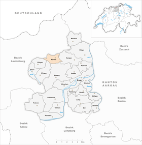
| Location of the municipality | |
  |
|
Mönthal (in the local dialect: ˈmyəndəl ) is a municipality in the Swiss canton of Aargau . It belongs to the Brugg district and is located around six kilometers northwest of the district capital.
geography
Mönthal is located in a hollow at the western end of a narrow side valley in the transition zone between the Folded Jura and the Table Jura , halfway between Brugg and Laufenburg . The village is almost entirely surrounded by hills. These include the Burghalde ( 643 m above sea level ) in the east, the Egg ( 602 m above sea level ) in the north, the Hommel ( 674 m above sea level ) in the west and the Winterhalde ( 600 m above sea level). ) in the south. A little more than half a kilometer west of the village is the hamlet of Ampferen ( 500 m above sea level ), there are also several individual farms.
The area of the municipality is 394 hectares , of which 179 hectares are forested and 35 hectares are built over. The highest point is the summit of the Hommel at 674 meters, the lowest is at 440 meters on the eastern border of the municipality. The municipality of Mönthal is part of the Aargau Jura Park, a “Regional Nature Park of National Importance”. Neighboring communities are Gansingen in the north, Remigen in the east, Bözberg in the south, Effingen in the south-west, Elfingen in the west and Laufenburg in the north-west.
history
Finds show that the valley has been inhabited since the Hallstatt period around 4,500 years ago. During the Bronze Age there was a fortified hilltop settlement on the Burghalde. The church of Muenuntal was first mentioned in a document in 1273. The place name comes from the Old High German (ze) muonintale and means "in the valley of the Muono". In the 13th century, the Habsburgs combined their sovereign rights west and north of Brugg in the Bözberg court. In addition to Mönthal, this also included Oberbözberg , Unterbözberg , Lauffohr , Linn , Rein , Remigen , Riniken , Rüfenach , Stilli and Villigen . In these villages the Habsburgs exercised blood jurisdiction , in Mönthal, Remigen and Villigen they also exercised lower jurisdiction .

From 1348 the court changed hands several times through pledging and in 1377 it finally came under the rule of Schenkenberg . In 1444 the village was sacked during the Old Zurich War . In 1460, the city of Bern occupied the rule of Schenkenberg militarily and added it to the subject areas in the Bernese Aargau . In 1528 the Bernese introduced the Reformation . In 1566 the judicial district of Bözberg was separated and from now on the court cases were heard in Stilli. In 1718 a fire destroyed part of the village.
In March 1798 the French took Switzerland, ousted the «Gracious Lords» of Bern and proclaimed the Helvetic Republic . Mönthal has been part of the canton of Aargau since then. Around 1850 the community still had over 500 inhabitants. As agriculture offered fewer and fewer opportunities to earn a living, many residents emigrated. By 1970 the population had dropped to less than half. But then the downward trend could be stopped, as the community could increasingly position itself as a quiet place to live. Within thirty years the population increased by more than three quarters.
Attractions
The reformed church from the Middle Ages was supplemented by a choir around 1480 . Until 1860 Mönthal was a branch of the parish of Brugg, the choir windows from 1590 were donated by the Brugg councilors.
coat of arms
The blazon of the municipal coat of arms reads: "Three yellow tips in blue, overlaid by three six-pointed yellow stars." The municipal seal of 1872 already used a similar coat of arms, but a river ran diagonally between the first and second mountain and the mountain peaks were rounded. Naturalistic representations contradict the rules of heraldry , which is why the coat of arms was changed in 1953.
population
The population developed as follows:
| year | 1764 | 1850 | 1900 | 1930 | 1950 | 1960 | 1970 | 1980 | 1990 | 2000 | 2010 |
| Residents | 253 | 515 | 333 | 287 | 257 | 255 | 239 | 280 | 397 | 398 | 413 |
On December 31, 2019, 395 people lived in Mönthal, the proportion of foreigners was 11.6%. In the 2015 census, 43.0% described themselves as Reformed and 23.0% as Roman Catholic ; 34.0% were non-denominational or of other faiths. In the 2000 census, 95.2% stated German as their main language, and 1.3% each stated Albanian and French .
Politics and law
The assembly of those entitled to vote, the municipal assembly , exercises legislative power. The executing authority is the five-member municipal council . He is elected by the people in the majority procedure, his term of office is four years. The parish council leads and represents the parish. To this end, it implements the resolutions of the municipal assembly and the tasks assigned to it by the canton. The Brugg District Court is the first instance responsible for legal disputes . Mönthal belongs to Friedensrichterkreis VIII (Brugg).
economy
According to the corporate structure statistics (STATENT) collected in 2015, Mönthal has around 100 jobs, 22% of which in agriculture, 35% in industry and 43% in the service sector. Many employed people are commuters and work in Brugg and the surrounding area or in the Fricktal .
Viticulture is also of importance . On the southwest slope of the Burghalde, an area of 2.4 hectares was planted with vines in 2018. The Riesling × Sylvaner , Blauburgunder and Zweigelt varieties predominate .
traffic
The village is located off the main traffic axes on the cantonal road 456 over the Ampferenhöhe ( 579 m above sea level ), a little-used Jura crossing to Sulz in the High Rhine Valley . Another road leads over the Bürersteig ( 550 m above sea level ) to Gansingen . A Postbus line runs from Brugg train station via Rüfenach to Mönthal.
education
Since July 2007 the community has neither a kindergarten nor a primary school . School children therefore have to go to the neighboring village of Remigen . All upper levels ( Realschule , Secondary School and District School ) can be attended in Brugg . The closest grammar schools are the Baden Cantonal School and the Wettingen Cantonal School .
literature
- Felix Müller: Mönthal. In: Historical Lexicon of Switzerland .
- Michael Stettler , Emil Maurer : The art monuments of the canton of Aargau . Ed .: Society for Swiss Art History . Volume II: The districts of Lenzburg and Brugg. Birkhäuser Verlag, Basel 1953, DNB 750561750 .
Web links
Individual evidence
- ↑ Cantonal population statistics 2019. Department of Finance and Resources, Statistics Aargau, March 30, 2020, accessed on April 2, 2019 .
- ↑ Cantonal population statistics 2019. Department of Finance and Resources, Statistics Aargau, March 30, 2020, accessed on April 2, 2019 .
- ↑ a b Beat Zehnder: The community names of the canton of Aargau . In: Historical Society of the Canton of Aargau (Ed.): Argovia . tape 100 . Verlag Sauerländer, Aarau 1991, ISBN 3-7941-3122-3 , p. 275-277 .
- ^ National map of Switzerland, sheet 1069, Swisstopo.
- ↑ Standard area statistics - municipalities according to 4 main areas. Federal Statistical Office , November 26, 2018, accessed on June 8, 2019 .
- ^ Joseph Galliker, Marcel Giger: Municipal coat of arms of the Canton of Aargau . Lehrmittelverlag des Kantons Aargau, book 2004, ISBN 3-906738-07-8 , p. 216 .
- ↑ Population development in the municipalities of the Canton of Aargau since 1850. (Excel) In: Eidg. Volkszählung 2000. Statistics Aargau, 2001, archived from the original on October 8, 2018 ; accessed on June 8, 2019 .
- ↑ Resident population by religious affiliation, 2015. (Excel) In: Population and Households, Community Tables 2015. Statistics Aargau, accessed on June 8, 2019 .
- ↑ Swiss Federal Census 2000: Economic resident population by main language as well as by districts and municipalities. (Excel) Statistics Aargau, archived from the original on August 10, 2018 ; accessed on June 8, 2019 .
- ↑ circles of justice of the peace. Canton of Aargau, accessed on June 18, 2019 .
- ↑ Statistics of the corporate structure (STATENT). (Excel, 157 kB) Statistics Aargau, 2016, accessed on June 8, 2019 .
- ↑ Grape harvest control 2018 Canton Aargau. (PDF, 2.4 MB) Agricultural Center Liebegg, 2019, accessed on June 18, 2019 .
Auenstein | Birr | Birrhard | Brugg | Bözberg | Bözen | Effingen | Elfingen | Habsburg | Hausen | Lupfig | Mandach | Mönthal | Garbage | Remigen | Riniken | Rüfenach | Schinznach | Thalheim | Veltheim | Villigen | Villnachern | Windisch
Former communities:
Altenburg |
Gallenkirch |
Hottwil |
Lauffohr |
Linn |
Oberbözberg |
Upper flax |
Pure |
Joke |
Schinznach-Bad |
Schinznach village |
Stilli |
Umiken |
Untersözberg
Canton of Aargau | Districts of the Canton of Aargau | Municipalities in the Canton of Aargau