
Goose singing
| Goose singing | |
|---|---|
 |
|
| State : |
|
| Canton : |
|
| District : | Laufenburg |
| BFS no. : | 4164 |
| Postal code : | 5272 |
| UN / LOCODE : | CH GAN |
| Coordinates : | 652344 / 266 060 |
| Height : | 382 m above sea level M. |
| Height range : | 362–698 m above sea level M. |
| Area : | 8.77 km² |
| Residents: | 1052 (December 31, 2019) |
| Population density : | 120 inhabitants per km² |
|
Proportion of foreigners : (residents without citizenship ) |
9.3% (December 31, 2019) |
| Website: | www.gansingen.ch |
 Gansigen seen from the hamlet of Galten |
|
| Location of the municipality | |
  |
|
Gansingen ( Swiss German : ˈg̥ɑnsig̥ə , in the local dialect younger ˈg̥ɑnsiŋ̥ə , older ˈg̥ɑusig̥ə ) is a municipality in the Swiss canton of Aargau . It belongs to the Laufenburg district and is located in the northeast of the Fricktal region , not far from the border with Germany .
geography
The community lies in the valley of the Mettauerbach, part of the Mettauertal , and consists of several settlements. From a geological point of view, the municipality belongs to the transition area between the Table Jura and the Folded Jura . Around two thirds of all residents live in the main settlement. The hamlet of Büren ( 410 m above sea level ) is about one kilometer south of it . In the center of Gansingen, the two-kilometer-long side valley of the Galterbach branches off to the southwest, at the upper end of which is the hamlet of Galten ( 480 m above sea level ).
Both valleys are very narrow and are limited by steep hills in places. The Schlatthalde ( 558 m above sea level ) and Gugli ( 607 m above sea level ) hills on the western municipal boundary, as well as the Laubberg ( 648 m above sea level ) on the eastern municipal border, are part of the Table Jura. The southern boundary of the municipality is formed by a chain of hills that belong to the Folded Jura. These are the Grosshalde ( 698 m above sea level ) in the southwest, the Ifang ( 667 m above sea level ) and the Oberegg ( 570 m above sea level ) in the south and the Bürerhorn ( 671 m above sea level ). in the south East. The Bürersteig , the pass crossing into the Aare valley, lies between the Bürerhorn and Oberegg .
The area of the municipality is 877 hectares , of which 333 hectares are forested and 70 hectares are built over. The highest point is on the Grosshalde, the lowest at 363 m above sea level. M. am Mettauerbach. The municipality of Gansingen is part of the Aargau Jura Park, a “Regional Nature Park of National Importance”. Neighboring communities are Mettauertal in the north and east, Remigen in the southeast, Mönthal in the south and Laufenburg in the west.
history
In the 5th or 6th century, after the retreat of the Romans , the Alemanni settled the upper Mettauertal. Gansungen was first mentioned in a document in 1240. The place name comes from the Old High German Gansingun and means "among the people of the Ganso". The village was under the jurisdiction of the respective owners of Bernau Castle in nearby Leibstadt . The sovereignty passed in 1386 from the Counts of Habsburg-Laufenburg to the older line of the Habsburgs . After the Waldshut War of 1468, they pledged the entire Fricktal to Burgundy . When the Burgundians were defeated by the Confederates during the Burgundian Wars , Gansingen came under Austrian rule again in 1477.
After the imperial reform of the Austrian Emperor Maximilian I in 1491, Gansingen belonged to Upper Austria . The Austrian authorities had fewer powers here than in the neighboring villages, as the Bernau rule retained a certain degree of independence from the Laufenburg cameraman. During the Swabian War of 1499, farmers from the Mettauertal plundered the villages in the neighboring Bernese Aargau . In the 17th century there were hardly any longer times of peace. The Rappenkrieg , a peasant uprising, lasted from 1612 to 1614. The Thirty Years' War , which also affected the Fricktal between 1633 and 1638, hit Gansingen particularly hard: after the Swedes withdrew , only four houses and the badly damaged church remained. Foreign troops also moved through the region during the War of the Palatinate Succession (1688–1697).
In 1797 the Fricktal became a French protectorate after the Peace of Campo Formio . During the Second Coalition War , the front line between the armies of France and Austria ran here . On February 20, 1802, Gansingen became a municipality in the Laufenburg district of the Fricktal canton , which joined the Helvetic Republic in August . The community had become Swiss. Gansingen has belonged to the canton of Aargau since March 19, 1803.
In a major fire in 1814, 29 houses in Gansingen were destroyed by flames, including the schoolhouse built seven years earlier. In 1829 the hamlet of Galten burned down completely. In the middle of the 19th century, due to bad harvests, a wave of emigration began; by 1910 the population had decreased by over a third. Gansingen remained dominated by agriculture until well into the 20th century. B. a nail forge. The population stagnated until the beginning of the 1980s, since then it has increased again slightly.
On September 21, 2007, the community assembly rejected the proposal to merge with Etzgen , Hottwil , Mettau , Oberhofen and Wil to form the Mettauertal community . The other municipalities then decided on March 20, 2008 to merge for the time being without Gansingen's involvement.
coat of arms
The blazon of the municipal coat of arms reads: "White goose with yellow armor, flying in blue on a green three-mountain." On the municipal seals of the 19th century, the goose was not seen in the shield, but on the upper edge of the shield of the canton's coat of arms. The version used today was introduced in 1939.
Attractions

The current church of the Roman Catholic parish was built in 1899 and renovated for the first time in 1972. Another interior renovation in 2002, followed by an exterior renovation in 2006. The interior is kept modern. The former rectory at Hinterdorfstrasse 3 is cantonal listed.
The Cheisacher Tower and the Cheisacher Observatory are located on the Grosshalde .
population
The population developed as follows:
| year | 1803 | 1850 | 1900 | 1930 | 1950 | 1960 | 1970 | 1980 | 1990 | 2000 | 2010 |
| Residents | 765 | 1053 | 723 | 706 | 790 | 698 | 717 | 741 | 876 | 927 | 958 |
On December 31, 2019, 1,052 people lived in Gansingen, the proportion of foreigners was 9.3%. In the 2015 census, 60.4% described themselves as Roman Catholic and 15.7% as Reformed ; 23.9% were non-denominational or of other faiths. In the 2000 census, 96.7% said their main language was German and 0.6% English .
Politics and law
The assembly of those entitled to vote, the municipal assembly , exercises legislative power. The executing authority is the five-member municipal council . He is elected by the people in the majority procedure, his term of office is four years. The parish council leads and represents the parish. To this end, it implements the resolutions of the municipal assembly and the tasks assigned to it by the canton. The District Court of Laufenburg is the first instance responsible for legal disputes . Gansingen belongs to the Friedensrichterkreis X (Mettau).
A partnership with Gansheim , a district of the Bavarian community of Marxheim, has existed since 1990 .
| Municipal council | Official title |
|---|---|
| Mario Hüsler | Mayor |
| Urban Erdin | Vice-Captain |
| Hanni Jappert-Senn | Councilor |
| Otto Senn | Municipal council |
| Severin Senn | Municipal council |
economy
According to the corporate structure statistics (STATENT) collected in 2015, there are around 180 jobs in Gansingen, 37% of them in agriculture, 9% in industry and 54% in the service sector. Most of the employed are commuters and work in the larger communities in the Fricktal and the lower Aare Valley .
traffic
Gansingen is on Kantonsstrasse 277, which leads from the Rhine Valley near Etzgen over the Bürersteig to Brugg . A side street leads over the hamlet of Galten to Sulz . The connection to the public transport network is provided by a post bus line between the Laufenburg and Brugg train stations .
education
The community has a kindergarten and a school house where primary school is taught. The district school , the secondary school and the Realschule can be attended in the Blauen school center in Laufenburg . The closest grammar schools are in Aarau ( old canton school and new canton school ); Due to an intercantonal agreement, young people from parts of the Fricktal can also complete the grammar school in Muttenz ( Canton Basel-Landschaft ) or in Basel .
photos

Local government

Village square

Parish church
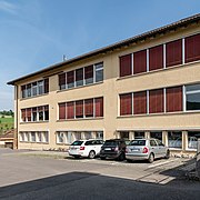
school

Old school house
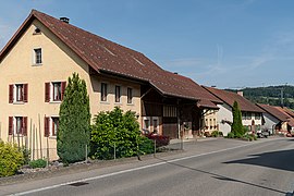
Row of houses


Web links
- Official website of the community of Gansingen
- Dominik Sauerländer: Goose singing. In: Historical Lexicon of Switzerland .
Individual evidence
- ↑ Cantonal population statistics 2019. Department of Finance and Resources, Statistics Aargau, March 30, 2020, accessed on April 2, 2019 .
- ↑ Cantonal population statistics 2019. Department of Finance and Resources, Statistics Aargau, March 30, 2020, accessed on April 2, 2019 .
- ↑ a b Beat Zehnder: The community names of the canton of Aargau . In: Historical Society of the Canton of Aargau (Ed.): Argovia . tape 100 . Verlag Sauerländer, Aarau 1991, ISBN 3-7941-3122-3 , p. 170-171 . as well as according to the material of the language atlas of German-speaking Switzerland.
- ↑ a b National map of Switzerland, sheet 1069, Swisstopo.
- ↑ Standard area statistics - municipalities according to 4 main areas. Federal Statistical Office , November 26, 2018, accessed on May 11, 2019 .
- ^ "Five clear yeses to the merger", Aargauer Zeitung , March 21, 2008
- ^ Joseph Galliker, Marcel Giger: Municipal coat of arms of the Canton of Aargau . Lehrmittelverlag des Kantons Aargau, book 2004, ISBN 3-906738-07-8 , p. 162 .
- ↑ Population development in the municipalities of the Canton of Aargau since 1850. (Excel) In: Eidg. Volkszählung 2000. Statistics Aargau, 2001, archived from the original on October 8, 2018 ; accessed on May 8, 2019 .
- ↑ Resident population by religious affiliation, 2015. (Excel) In: Population and Households, Community Tables 2015. Statistics Aargau, accessed on May 11, 2019 .
- ↑ Swiss Federal Census 2000: Economic resident population by main language as well as by districts and municipalities. (Excel) Statistics Aargau, archived from the original on August 10, 2018 ; accessed on May 8, 2019 .
- ↑ circles of justice of the peace. Canton of Aargau, accessed on June 19, 2019 .
- ↑ Potrait. Community of Gansingen, accessed on June 19, 2019 .
- ↑ Statistics of the corporate structure (STATENT). (Excel, 157 kB) Statistics Aargau, 2016, accessed on May 8, 2019 .
Eiken | Frick | Goose singing | Gipf-Oberfrick | Herznach | Hornussen | Kaisten | Laufenburg | Mettauertal | Münchwilen | Oberhof | Oeschgen | Rake hole | Armchairs | Ueken | Wittnau | Wölflinswil | Draw
Former municipalities: Etzgen | Ittenthal | Mettau | Oberhofen | Sulz | Wil
Canton of Aargau | Districts of the Canton of Aargau | Municipalities in the Canton of Aargau