
Wölflinswil
| Wölflinswil | |
|---|---|
 |
|
| State : |
|
| Canton : |
|
| District : | Laufenburg |
| BFS no. : | 4182 |
| Postal code : | 5063 |
| Coordinates : | 642 172 / 256 842 |
| Height : | 437 m above sea level M. |
| Height range : | 398–864 m above sea level M. |
| Area : | 9.51 km² |
| Residents: | 1040 (December 31, 2019) |
| Population density : | 109 inhabitants per km² |
|
Proportion of foreigners : (residents without citizenship ) |
8.1% (December 31, 2019) |
| Website: | www.woelflinswil.ch |
 Village square of Wölflinswil, in the background the classical parish church of St. Mauritius (1821) |
|
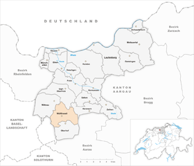
| Location of the municipality | |
  |
|
Wölflinswil ( Swiss German : ˌvœlflisˈʋiːl ) is a municipality in the Swiss canton of Aargau . It belongs to the Laufenburg district , is located in the south of the Fricktal region and borders on the Canton of Solothurn .
geography
The municipality is located in the transition zone between the Table Jura in the north and the Folded Jura in the south. The village itself is located in the narrow valley north of the Benkerjoch , which is bordered on both sides by hills. These rise steeply in the lower area and merge into extensive plateaus in the upper area. These are the Altenberg ( 579 m above sea level ) in the west and the Fürberg ( 536 m above sea level ) in the east, both of which are used for agriculture. Two side valleys branch off in the center of the village; one leads south-west up to the castle ( 790 m above sea level ), the second south-east to Strihenmatt, which is around 580 meters high. This is where the steep ascent up to Strihe ( 867 m above sea level ) begins , the highest mountain in the whole of the canton of Aargau and the second highest point in the canton.
The area of the municipality is 951 hectares , of which 293 hectares are forested and 67 hectares are built over. The highest point is 865 m above sea level. M. on the ridge of the Strihe, the deepest at 400 m above sea level. M. on the northern boundary of the municipality. The municipality of Wölflinswil is part of the Aargau Jura Park, a "Regional Nature Park of National Importance". Neighboring communities are Gipf-Oberfrick in the north, Herznach in the northeast, Densbüren in the east, Oberhof in the south, Kienberg in the west and Wittnau in the northwest.
history
The first mention of the Church of Wulfliswile took place in 1180 in a land register of the Counts of Homberg-tier stone. The place name comes from the Middle High German Wulfineswilere and means "Hofsiedlung des Wulfin". At the beginning of the 13th century the village came into the possession of the Habsburgs , who pledged the entire Fricktal to Burgundy after the Waldshut War of 1468 . When the Burgundians were defeated by the Confederates during the Burgundian Wars , Wölflinswil came under Austrian rule again in 1477.
After the imperial reform of the Austrian Emperor Maximilian I in 1491, Wölflinswil belonged to Upper Austria and was located in the Fricktal region, a subordinate administrative unit of the Rheinfelden cameramen (from 1752 in the Breisgau Upper Office ). In 1513 the governors and councilors of Upper Alsace confess in a document that the knight Ulrich von Habsburg bought the "village of Wolffswiller in the Fricktal" from Petterman von Ebtingen and his siblings for the hands of the emperor. In the 17th century there were hardly any longer times of peace. The Rappenkrieg , a peasant uprising, lasted from 1612 to 1614. The Thirty Years' War , which also affected the Fricktal between 1633 and 1638, hit Wölflinswil particularly hard. The village was devastated by Swedish troops. Buildings that survived this destruction are still called "Swedish houses" today. Foreign troops also moved through the region during the War of the Palatinate Succession (1688–1697).

In 1797 the Fricktal became a French protectorate after the Peace of Campo Formio . During the Second Coalition War , the front line between the armies of France and Austria ran here . On February 20, 1802, the canton of Fricktal was founded , which joined the Helvetic Republic in August . The village in the Frick district had thus become Swiss. Since March 19, 1803, Wölflinswil has belonged to the canton of Aargau. In the same year, Oberhof separated , which has since been an independent municipality.
The mining of iron ore played an important role throughout the Middle Ages, and the ore mines of Wölflinswil were considered particularly profitable. The ore mining was finally stopped in 1743. The trimmings , the weaving of silk ribbons in homework , provided a modest additional income to agriculture during the 19th and early 20th centuries . Nevertheless, the lack of economic opportunities forced numerous residents to emigrate. The population stagnated for decades; it has only increased slightly since the Benkerjoch pass road was expanded in 1977.
Attractions
coat of arms
The blazon of the municipal coat of arms reads: "Red wolf looking back in yellow." The coat of arms was introduced in 1939, but the wolf was kept in brown, which contradicts the heraldic color rules. In 1953 the animal was colored red.
population
The population developed as follows:
| year | 1768 | 1800 | 1850 | 1900 | 1930 | 1950 | 1960 | 1970 | 1980 | 1990 | 2000 | 2010 |
| Residents | 498 | 806 | 739 | 656 | 613 | 641 | 639 | 655 | 738 | 721 | 784 | 984 |
On December 31, 2019, 1,040 people lived in Wölflinswil, the proportion of foreigners was 8.1%. In the 2015 census, 52.5% described themselves as Roman Catholic and 19.0% as Reformed ; 29.0% were non-denominational or of other faiths. In the 2000 census, 96.2% stated German as their main language and 1.8% Albanian .
Politics and law
The assembly of those entitled to vote, the municipal assembly , exercises legislative power. The executing authority is the five-member municipal council . He is elected by the people in the majority procedure, his term of office is four years. The parish council leads and represents the parish. To this end, it implements the resolutions of the municipal assembly and the tasks assigned to it by the canton. The District Court of Laufenburg is the first instance responsible for legal disputes . Wölflinswil belongs to the peace judges group X (Mettau).
| Municipal council | Official title |
|---|---|
| Barbara Fricker | Mayor |
| Gebi Maier | Vice-Captain |
| Benjamin Duke | Municipal council |
| Gabi Reimann-Treier | Councilor |
| Hansjörg Treier | Municipal council |
economy
According to the corporate structure statistics (STATENT) collected in 2015, there are around 330 jobs in Wölflinswil, 34% of them in agriculture, 27% in industry and 39% in the service sector. Wood processing, construction and transport companies play an important role. Most of the employed are commuters and work in the larger communities in the Fricktal and in the Aarau and Basel regions .
traffic
Wölflinswil is located on the northern approach to Kantonsstrasse 487 over the Benkerjoch , the middle of the three connections between Aarau and the Fricktal. Eight kilometers from Wölflinswil there is a motorway connection to the A3 near Frick . The connection to the public transport network is provided by a Postbus line that runs from Aarau train station over the Benkerjoch to Frick. The Oberfricktaler Eisenweg begins in Wölflinswil . A night bus runs from Frick via Wölflinswil to Oberhof .
education
The community has a kindergarten and a school house where primary school is taught. The Realschule and the secondary school can be attended in Gipf-Oberfrick , the district school in Frick . The closest grammar schools are the Alte Kantonsschule and the Neue Kantonsschule , both in Aarau .
photos
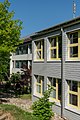
Huebmet schoolhouse
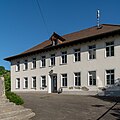
Old school house, Stöckli

Rectory, parish barn, parish church and old school house
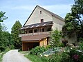
Former mill (1674)


Personalities
- Peter Bircher (* 1939), politician
- Robert Reimann (1911–1987), politician
Web links
- Official website of the municipality of Wölflinswil
- Dominik Sauerländer: Wölflinswil. In: Historical Lexicon of Switzerland .
Individual evidence
- ↑ Cantonal population statistics 2019. Department of Finance and Resources, Statistics Aargau, March 30, 2020, accessed on April 2, 2019 .
- ↑ Cantonal population statistics 2019. Department of Finance and Resources, Statistics Aargau, March 30, 2020, accessed on April 2, 2019 .
- ↑ a b Beat Zehnder: The community names of the canton of Aargau . In: Historical Society of the Canton of Aargau (Ed.): Argovia . tape 100 . Verlag Sauerländer, Aarau 1991, ISBN 3-7941-3122-3 , p. 478-479 .
- ^ National map of Switzerland, sheet 1069, Swisstopo.
- ↑ Standard area statistics - municipalities according to 4 main areas. Federal Statistical Office , November 26, 2018, accessed on May 11, 2019 .
-
↑ Thurneysen, Emanuel: "An attempt at a description of historical and natural curiosities of the Basel landscape", 1761, p. 2348, Google Books :
"In the year 1505 Ulrich von Habsburg was a knight, pledger of the Rheinfelden stone and had the name of his Roman. Royal Majesty; [...] ». - ↑ Augustiner Urk. No.274, December 22, 1513, archive catalog Basel Stadt
- ^ Joseph Galliker, Marcel Giger: Municipal coat of arms of the Canton of Aargau . Lehrmittelverlag des Kantons Aargau, book 2004, ISBN 3-906738-07-8 , p. 321 .
- ↑ Population development in the municipalities of the Canton of Aargau since 1850. (Excel) In: Eidg. Volkszählung 2000. Statistics Aargau, 2001, archived from the original on October 8, 2018 ; accessed on May 8, 2019 .
- ↑ Resident population by religious affiliation, 2015. (Excel) In: Population and Households, Community Tables 2015. Statistics Aargau, accessed on May 11, 2019 .
- ↑ Swiss Federal Census 2000: Economic resident population by main language as well as by districts and municipalities. (Excel) Statistics Aargau, archived from the original on August 10, 2018 ; accessed on May 8, 2019 .
- ↑ circles of justice of the peace. Canton of Aargau, accessed on June 19, 2019 .
- ↑ Statistics of the corporate structure (STATENT). (Excel, 157 kB) Statistics Aargau, 2016, accessed on May 8, 2019 .
Eiken | Frick | Goose singing | Gipf-Oberfrick | Herznach | Hornussen | Kaisten | Laufenburg | Mettauertal | Münchwilen | Oberhof | Oeschgen | Rake hole | Armchairs | Ueken | Wittnau | Wölflinswil | Draw
Former municipalities: Etzgen | Ittenthal | Mettau | Oberhofen | Sulz | Wil
Canton of Aargau | Districts of the Canton of Aargau | Municipalities in the Canton of Aargau