Ittenthal
| Ittenthal | ||
|---|---|---|
| State : |
|
|
| Canton : |
|
|
| District : | Laufenburg | |
| Residential municipality : | Kaisten | |
| Postal code : | 5083 | |
| former BFS no. : | 4168 | |
| Coordinates : | 646.75 thousand / 263224 | |
| Height : | 398 m above sea level M. | |
| Residents: | 236 (Dec. 31, 2009) | |
|
Proportion of foreigners : (residents without citizenship ) |
8.1% (Dec 31, 2009) | |
|
Ittenthal. |
||
| map | ||
|
|
||
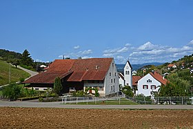
Ittenthal ( Swiss German : ˈytlətə ) is a village in the Swiss canton of Aargau . It is located in the northeast of the Fricktal region , just under five kilometers from the border with Germany . Ittenthal was an independent community in the Laufenburg district until the end of 2009, and since then it has belonged to the Kaisten community .
geography
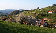
The smallest village in the Fricktal is located in a hollow at the upper end of a small side valley. The valley opens to the north to the Rhine valley and is enclosed on three sides by the hills of the Table Jura . In the west lies the Frickberg ( 650 m above sea level ), in the south the Moos ( 622 m above sea level ) and in the east the Schinberg ( 722 m above sea level ). The Frickberg and the Moos rise steeply in the lower area and merge into gently sloping levels in the upper area (the municipality boundary followed the edge of the terrain). The Schinberg, on the other hand, with its narrow ridge is rather untypical for this area and looks more like a hill in the Jura .
The area of the former municipality was 389 hectares, of which 169 hectares were forested and 14 hectares were built over. The highest point was at 722 meters on the summit of the Schinberg, the lowest at 370 meters on the northern municipal border. Neighboring communities were Kaisten in the north, Sulz in the east, Hornussen in the south and Frick in the west.
history
Utendal was first mentioned in a document in 1297. The place name is derived from the Old High German Uttintale and means "Valley of Utto". The largest landowner was the aristocratic Säckingen dynasty , which also exercised lower jurisdiction . The sovereignty lay with the Counts of Habsburg-Laufenburg until 1386 and then passed to the older line of the Habsburgs . After the Waldshut War of 1468, they pledged the entire Fricktal to Burgundy . When the Burgundians were defeated by the Confederates during the Burgundian Wars , Ittenthal came under Austrian rule again in 1477.
After the reform of the empire by Emperor Maximilian I in 1491, Ittenthal belonged to Upper Austria and was part of the Laufenburg cameramen . In the 17th century there were hardly any longer times of peace. The Rappenkrieg , a peasant uprising, lasted from 1612 to 1614. The Thirty Years War , which also affected the Fricktal between 1633 and 1638, threw the village back in its economic development. Foreign troops also moved through the region during the War of the Palatinate Succession (1688–1697). In the 18th century, thirty families emigrated to the Banat (now Romania ) as part of the Austrian migration policy , where they settled in Saderlach together with other Fricktalers and Hotzenwäldern .
In 1797 the Fricktal became a French protectorate after the Peace of Campo Formio . During the Second Coalition War , the front line between the armies of France and Austria ran here . On February 20, 1802 Ittenthal became a municipality in the Laufenburg district of the canton of Fricktal , which joined the Helvetic Republic in August ; Ittenthal had thus become Swiss. Since March 19, 1803, the municipality belonged to the canton of Aargau.
In 1870 the community still had 291 inhabitants, but this number decreased by a third in the following hundred years due to continued emigration. In the 19th century sandstone was extracted from a quarry . Between 1924 and 1926 large amounts of earth loosened on the western slope of the Schinberg and slid down into the valley; four hectares of forest and ten hectares of meadows were destroyed. The slope was later stabilized by afforestation. Ittenthal has remained an agricultural village to this day; There is a lack of industry and commerce.
On January 1, 2010 Ittenthal was merged with the neighboring municipality of Kaisten . After the municipal assemblies had passed a corresponding resolution in November 2008, this decision was confirmed at the ballot box on February 8, 2009. In Ittenthal, 171 voters were in favor of the merger, 82 against.
coat of arms
The blazon of the former municipality and today's village coat of arms reads: "In blue the upper part of a lily stick with a white lily on a yellow stem with four yellow leaves, accompanied by two six-pointed yellow stars." Until 1949 the municipality had no coat of arms of its own. After 35 drafts had been drawn up, the community assembly agreed on the lily stick, the symbol of St. Joseph , who is also the patron saint of the chapel. The stars symbolize the marriage to Mary .
population
Population development (without Ittenthal) :
| year | 1803 | 1850 | 1900 | 1930 | 1950 | 1960 | 1970 | 1980 | 1990 | 2000 |
| Residents | 171 | 265 | 217 | 244 | 221 | 196 | 186 | 200 | 213 | 222 |
On December 31, 2008, 218 people lived in Ittenthal, of whom only ten were foreigners. At the 2000 census, 64.4% were Roman Catholic and 23.0% were Reformed; 1.8% were of other faiths. 98.2% named German as their main language.
traffic
Ittenthal is located away from through traffic and is accessed from Kaisten by Kantonsstrasse 464. The connection to the public transport network is via a post bus line to Laufenburg train station .
Attractions
Web links
- Dominik Sauerländer: Ittenthal. In: Historical Lexicon of Switzerland .
Individual evidence
- ↑ a b Beat Zehnder: The community names of the canton of Aargau . In: Historical Society of the Canton of Aargau (Ed.): Argovia . tape 100 . Verlag Sauerländer, Aarau 1991, ISBN 3-7941-3122-3 , p. 210-211 .
- ^ National map of Switzerland, sheet 1069, Swisstopo
- ↑ Aargauer Zeitung : From now on together through community life. February 8, 2009.
- ^ Joseph Galliker, Marcel Giger: Municipal coat of arms of the canton of Aargau . Lehrmittelverlag des Kantons Aargau, book 2004, ISBN 3-906738-07-8 , p. 184 .
- ↑ Population development in the municipalities of the Canton of Aargau since 1850. (Excel) In: Eidg. Volkszählung 2000. Statistics Aargau, 2001, archived from the original on October 8, 2018 ; accessed on May 9, 2019 .
- ↑ Swiss Federal Census 2000: Economic resident population by religious affiliation as well as by districts and municipalities. (Excel) Statistics Aargau, archived from the original on August 10, 2018 ; accessed on May 9, 2019 .
- ↑ Swiss Federal Census 2000: Economic resident population by main language as well as by districts and municipalities. (Excel) Statistics Aargau, archived from the original on August 10, 2018 ; accessed on May 9, 2019 .


