
Oberhof AG
| AG is the abbreviation for the canton of Aargau in Switzerland and is used to avoid confusion with other entries of the name Oberhof (disambiguation) . |
| Oberhof | |
|---|---|
 |
|
| State : |
|
| Canton : |
|
| District : | Laufenburg |
| BFS no. : | 4173 |
| Postal code : | 5062 |
| Coordinates : | 642 784 / 255 818 |
| Height : | 466 m above sea level M. |
| Height range : | 453–870 m above sea level M. |
| Area : | 8.20 km² |
| Residents: | 591 (December 31, 2019) |
| Population density : | 69 inhabitants per km² |
|
Proportion of foreigners : (residents without citizenship ) |
11.5% (December 31, 2019) |
| Website: | www.oberhof.ch |
 Oberhof |
|
| Location of the municipality | |
  |
|
Oberhof ( Swiss German : ˈɔbərˌhoːf ) is a municipality in the Swiss canton of Aargau . It belongs to the Laufenburg district , is located in the south of the Fricktal region and borders on the Canton of Solothurn .
geography
The village is located in the narrow valley north of the Benkerjoch and is bordered on both sides by the steep hills of the Folded Jura . These rise evenly in the lower area and then merge into towering, narrow ridges. These are the castle ( 790 m above sea level ) in the west, the Wasserflue ( 866 m above sea level ) in the south, the Asperstrihe ( 838 m above sea level ) in the southeast and the Strihe ( 866 m above sea level) . M. ) in the east. Upstream of the Wasserflue is the summer heap ( 800 m above sea level ). Between these two hills are the pilgrims' courtyards, a group of isolated farmsteads at an average height of 650 meters. The south-eastern point of the municipality is the 674 meter high Benkerjoch, one of the pass crossings between the Fricktal and the Aare valley further south . Below the Benkerjoch lies the hamlet of Benken ( 579 m above sea level ). In the south-west the community area extends to Salhöhe ( 779 m above sea level ), but there is no direct road connection between the village and this pass.
The area of the municipality is 820 hectares , of which 341 hectares are forested and 49 hectares are built over. The highest point is 865 m above sea level. M. on the ridge of the Strihe, the deepest at 455 m above sea level. M. on the northern boundary of the municipality. The municipality of Oberhof is part of the Aargau Jura Park, a "Regional Nature Park of National Importance". Neighboring communities are Wölflinswil in the north, Densbüren in the east, Küttigen in the south-east, Erlinsbach in the south and Kienberg in the north-west.
history
In the Middle Ages, Oberhof was under the rule of the Counts of Homberg-Tierstein. At the beginning of the 13th century the village became the property of the Habsburgs . After the Waldshut War of 1468, they pledged the entire Fricktal to Burgundy . When the Burgundians were defeated by the Confederates during the Burgundian Wars , Oberhof came under Austrian rule again in 1477. After the imperial reform of the Austrian Emperor Maximilian I in 1491, Oberhof belonged to Upper Austria and was in the Fricktal region, a subordinate administrative unit of the Rheinfelden cameramen (from 1752 in the Oberamt Breisgau ). After Bern had taken possession of the areas south of the Benkerjoch, Oberhof was on the border with the Bernese Aargau from 1499 .
Oberhoff was first mentioned in a document relatively late in 1630. The place name comes from the Middle High German (ze dem) upper hofe and means "at the upper homestead". In the 17th century there were hardly any longer times of peace. The Rappenkrieg , a peasant uprising, lasted from 1612 to 1614. The Thirty Years War , which also affected the Fricktal between 1633 and 1638, hit Oberhof particularly hard. The village was devastated by Swedish troops. Foreign troops also moved through the region during the War of the Palatinate Succession (1688–1697).

In 1797 the Fricktal became a French protectorate after the Peace of Campo Formio . During the Second Coalition War , the front line between the armies of France and Austria ran here . On February 20, 1802, the canton of Fricktal was founded , which joined the Helvetic Republic in August . The village in the Frick district had thus become Swiss. Since March 19, 1803, Oberhof has belonged to the canton of Aargau. In the same year the separation from Wölflinswil and the formation of an independent municipality took place.
The trimmings , the weaving of silk ribbons in homework , provided a modest additional income to agriculture during the 19th and early 20th centuries . Nevertheless, the lack of economic opportunities forced numerous residents to emigrate. Between 1850 and 1960 the population decreased by more than a third. Since the expansion of the Benkerjoch pass road in 1977 it has increased again slightly.
coat of arms
The blazon of the municipal coat of arms reads: "In blue on five green mountains, white house with a black roof in eaves position, next to two green fir trees with brown trunks." The first coat of arms from 1939 depicted a three-dimensional courtyard flanked by two fir trees. The shape used today was introduced in 1946. In 2002, the municipal assembly rejected the State Archives' proposal to color the brown trunks red or green in accordance with the heraldry rules .
population
The population developed as follows:
| year | 1768 | 1850 | 1900 | 1930 | 1950 | 1960 | 1970 | 1980 | 1990 | 2000 | 2010 |
| Residents | 295 | 626 | 487 | 475 | 424 | 394 | 436 | 416 | 462 | 496 | 570 |
On December 31, 2019, 591 people lived in Oberhof, the proportion of foreigners was 11.5%. In the 2015 census, 54.3% described themselves as Roman Catholic and 18.4% as Reformed ; 27.3% were non-denominational or of other faiths. In the 2000 census, 98.2% stated German as their main language.
Politics and law
The assembly of those entitled to vote, the municipal assembly , exercises legislative power. The executing authority is the five-member municipal council . He is elected by the people in the majority procedure, his term of office is four years. The parish council leads and represents the parish. To this end, it implements the resolutions of the municipal assembly and the tasks assigned to it by the canton. The District Court of Laufenburg is the first instance responsible for legal disputes . Oberhof belongs to the peace judges group X.
| Municipal council | Official title |
|---|---|
| Roger Fricker | Mayor |
| Susanne Häfliger-Stäuble | Vice-Captain |
| René Erb | Municipal council |
| Heinz Herzog | Municipal council |
| Markus Liebi | Municipal council |
economy
According to the company structure statistics (STATENT) collected in 2017, Oberhof has around 140 employees (87 full-time equivalents), 47% of them in agriculture, 27% in industry and 26% in the service sector. Many workers are commuters and work in the larger communities of the Fricktal and in the Aarau region .
traffic
Oberhof is located on the northern approach to Kantonsstrasse 487 over the Benkerjoch , the middle of the three connections between Aarau and the Fricktal. Nine kilometers from Oberhof there is a motorway connection to the A3 near Frick . The connection to the public transport network is provided by a Postbus line that runs from Aarau train station over the Benkerjoch to Frick. On weekends there is a night bus from Frick to Oberhof.
education
The community has a kindergarten and a school house where primary school is taught. The Realschule and the secondary school can be attended in Gipf-Oberfrick , the district school in Frick . The closest grammar schools are the Alte Kantonsschule and the Neue Kantonsschule , both in Aarau .
photos

Old school house and Joseph's chapel

Glass painting by Jan Janczak (1975)
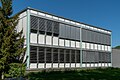
Schoolhouse Moos
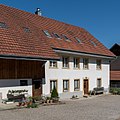
Typical former farmhouse

Typical former farmhouse


Personalities
- Fritz Reimann (1924–2018), politician
Web links
- Official website of the municipality of Oberhof
- Dominik Sauerländer: Oberhof. In: Historical Lexicon of Switzerland .
Individual evidence
- ↑ Cantonal population statistics 2019. Department of Finance and Resources, Statistics Aargau, March 30, 2020, accessed on April 2, 2019 .
- ↑ Cantonal population statistics 2019. Department of Finance and Resources, Statistics Aargau, March 30, 2020, accessed on April 2, 2019 .
- ↑ a b Beat Zehnder: The community names of the canton of Aargau . In: Historical Society of the Canton of Aargau (Ed.): Argovia . tape 100 . Verlag Sauerländer, Aarau 1991, ISBN 3-7941-3122-3 , p. 315-316 .
- ^ National map of Switzerland, sheet 1069, Swisstopo.
- ↑ Standard area statistics - municipalities according to 4 main areas. Federal Statistical Office , November 26, 2018, accessed on May 11, 2019 .
- ^ Joseph Galliker, Marcel Giger: Municipal coat of arms of the Canton of Aargau . Lehrmittelverlag des Kantons Aargau, book 2004, ISBN 3-906738-07-8 , p. 234 .
- ↑ Population development in the municipalities of the Canton of Aargau since 1850. (Excel) In: Eidg. Volkszählung 2000. Statistics Aargau, 2001, archived from the original on October 8, 2018 ; accessed on May 8, 2019 .
- ↑ Resident population by religious affiliation, 2015. (Excel) In: Population and Households, Community Tables 2015. Statistics Aargau, accessed on May 11, 2019 .
- ↑ Swiss Federal Census 2000: Economic resident population by main language as well as by districts and municipalities. (Excel) Statistics Aargau, archived from the original on August 10, 2018 ; accessed on May 8, 2019 .
- ↑ circles of justice of the peace. Canton of Aargau, accessed on June 19, 2019 .
- ↑ Statistics of the corporate structure (STATENT). (Excel, 2.0 MB) Statistics Aargau, 2017, accessed on February 12, 2020 .
Eiken | Frick | Goose singing | Gipf-Oberfrick | Herznach | Hornussen | Kaisten | Laufenburg | Mettauertal | Münchwilen | Oberhof | Oeschgen | Rake hole | Armchairs | Ueken | Wittnau | Wölflinswil | Draw
Former municipalities: Etzgen | Ittenthal | Mettau | Oberhofen | Sulz | Wil
Canton of Aargau | Districts of the Canton of Aargau | Municipalities in the Canton of Aargau